Parryville, Pennsylvania facts for kids
Quick facts for kids
Parryville, Pennsylvania
|
|
|---|---|
|
Borough
|
|

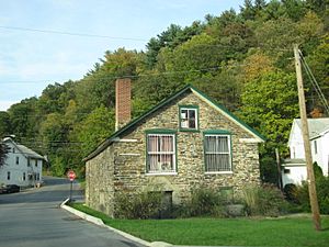
Parryville in October 2011
|
|

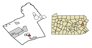
Location of Parryville in Carbon County, Pennsylvania (left) and of Carbon County in Pennsylvania (right)
|
|
| Country | United States |
| State | Pennsylvania |
| County | Carbon |
| Area | |
| • Total | 1.63 sq mi (4.22 km2) |
| • Land | 1.61 sq mi (4.17 km2) |
| • Water | 0.02 sq mi (0.04 km2) |
| Elevation | 450 ft (140 m) |
| Population
(2020)
|
|
| • Total | 416 |
| • Density | 258.22/sq mi (99.70/km2) |
| Time zone | UTC-5 (EST) |
| • Summer (DST) | UTC-4 (EDT) |
| ZIP Code |
18244
|
| Area codes | 610 |
| FIPS code | 42-58304 |
| Website | parryville.org |
Parryville is a small town, called a borough, located in Carbon County, Pennsylvania, United States. It's part of Northeastern Pennsylvania. The town is about 3 miles (4.8 km) southeast of Lehighton and 1 mile (1.6 km) north of Bowmanstown. You can find it off Route 248. Parryville is also about 4 miles (6.4 km) northwest of Palmerton.
The town sits about 450 feet (137 meters) above sea level. In 2020, the population of Parryville was 416 people.
Contents
History of Parryville
Parryville is located about six miles south of Jim Thorpe, Pennsylvania. Its history began in the late 1700s.
Early Settlers and Mills
In 1780, Peter Frantz was the first person to settle on this land. A year later, in 1781, Leonard Beltz and Frederick Scheckler arrived. They built a stone gristmill near the Pohopoco Creek. A gristmill is a place where grain is ground into flour.
Leonard Beltz married Elizabeth Boyer, and they had twelve children. Mrs. Beltz lived to be 105 years old! In 1815, Beltz and Scheckler sold the mill and land to Jacob and Peter Stein. The Steins improved the property by building a new hotel.
Lumber and Railroads
In 1836, the Pine Forest Lumber Company set up its main office in Parryville. This company owned a lot of timber land. They built new sawmills and other facilities near the creek. The town was named after the company's president, Daniel Parry. It was first called Parrysville, then later Parryville.
Also in 1836, the Beaver Meadow Railroad and Coal Company built a railroad line. This line allowed people to cross the river and made Parryville an important shipping point. The Lehigh Coal and Navigation Company used the creek to move coal on boats to other areas. However, in 1841, a big flood damaged the railroad tracks and shipping docks. That part of the railroad was never rebuilt.
Iron Production and Town Growth
Around 1855, Dennis Bauman and his brother Henry started an anthracite blast furnace in the village. A blast furnace is a large oven used to melt iron ore. At first, water from the Pohopoco Creek powered the furnace. Two years later, the Carbon Iron Company bought the plant and started using steam power instead.
Parryville became its own school district in 1867. Then, in early 1875, it officially became a borough. A borough is a type of self-governing town. Dennis Bauman, who helped start the iron furnace, became the first chief leader, called a burgess. By 1880, the town had 657 people living there.
Geography
Parryville is located in the southern part of Carbon County. It sits near the Pohopoco Creek, just north of where the creek joins the Lehigh River. This meeting point of two rivers is called a confluence.
The U.S. Census Bureau reports that Parryville covers a total area of about 1.63 square miles (4.22 square kilometers). Most of this area, about 1.61 square miles (4.17 square kilometers), is land. Only a small part, about 0.02 square miles (0.04 square kilometers), is water.
Population Information
As of the year 2000, there were 478 people living in Parryville. These people lived in 189 households, with 140 of them being families.
| Historical population | |||
|---|---|---|---|
| Census | Pop. | %± | |
| 1880 | 657 | — | |
| 1890 | 605 | −7.9% | |
| 1900 | 723 | 19.5% | |
| 1910 | 590 | −18.4% | |
| 1920 | 578 | −2.0% | |
| 1930 | 553 | −4.3% | |
| 1940 | 521 | −5.8% | |
| 1950 | 598 | 14.8% | |
| 1960 | 580 | −3.0% | |
| 1970 | 528 | −9.0% | |
| 1980 | 481 | −8.9% | |
| 1990 | 488 | 1.5% | |
| 2000 | 478 | −2.0% | |
| 2010 | 525 | 9.8% | |
| 2020 | 416 | −20.8% | |
| Sources: | |||
The population density was about 293 people per square mile (113 people per square kilometer). There were 222 housing units in the borough.
About 23.8% of households had children under 18 living with them. Most households (62.4%) were married couples. About 19.6% of all households were single individuals. About 9.5% of households had someone living alone who was 65 years or older.
The average household had 2.53 people, and the average family had 2.91 people.
The population was spread out by age:
- 18.8% were under 18 years old.
- 7.9% were between 18 and 24 years old.
- 29.5% were between 25 and 44 years old.
- 28.9% were between 45 and 64 years old.
- 14.9% were 65 years or older.
The average age in the borough was 41 years.
Transportation

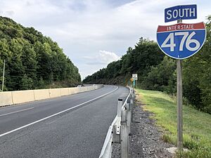
I-476/Pennsylvania Turnpike Northeast Extension south in Parryville
|
As of 2007, Parryville had about 7.80 miles (12.55 km) of public roads. Some roads are maintained by the Pennsylvania Turnpike Commission (PTC), some by the Pennsylvania Department of Transportation (PennDOT), and some by the borough itself.
Interstate 476, also known as the Pennsylvania Turnpike's Northeast Extension, goes through the western part of Parryville. You can get onto I-476 from Exit 74 (which connects to U.S. Route 209), just north of the town limits. I-476 goes south about 20 miles (32 km) to the Allentown area and north about 50 miles (80 km) to Scranton.
Pennsylvania Route 248 also runs through Parryville. It goes from northwest to southeast across the southwestern part of the borough, running alongside the Lehigh River.
See also
 In Spanish: Parryville para niños
 | Selma Burke |
 | Pauline Powell Burns |
 | Frederick J. Brown |
 | Robert Blackburn |


