
Paruna, South Australia facts for kids
Quick facts for kids ParunaSouth Australia |
|||||||||||||||
|---|---|---|---|---|---|---|---|---|---|---|---|---|---|---|---|

Railway Terrace, the main street of Paruna
|
|||||||||||||||

Paruna
Location in South Australia
|
|||||||||||||||
| Established | 23 July 1914 (town) 28 September 2000 (locality) |
||||||||||||||
| Postcode(s) | 5311 | ||||||||||||||
| Elevation | 59 m (194 ft) at former railway station | ||||||||||||||
| Time zone | ACST (UTC+9:30) | ||||||||||||||
| • Summer (DST) | ACST (UTC+10:30) | ||||||||||||||
| Location | |||||||||||||||
| LGA(s) | District Council of Loxton Waikerie | ||||||||||||||
| Region | Murray and Mallee | ||||||||||||||
| County | Alfred | ||||||||||||||
| State electorate(s) | Chaffey | ||||||||||||||
| Federal Division(s) | Barker | ||||||||||||||
|
|||||||||||||||
|
|||||||||||||||
| Footnotes | Adjoining localities | ||||||||||||||
Paruna is a small township located in eastern South Australia. It sits on the Browns Well Highway, where it used to cross the old Barmera railway line. Paruna is about 237 kilometers (147 miles) east of Adelaide, the capital city of South Australia.
In 2021, a census showed that Paruna and the areas around it had a population of just 36 people. This number was lower than in 2016. The name "Paruna" comes from an Aboriginal word that means "stopping place."
Contents
The History of Paruna
How Paruna Was Established
The government officially declared Paruna a town on July 23, 1914. It was built on land in an area called the Hundred of Kekwick, just north of the Paruna railway station. The current boundaries for the wider Paruna area were set on September 28, 2000. The original town site is roughly in the middle of this larger area.
The Railway's Role in Paruna
The Barmera railway line from Adelaide reached Paruna on May 1, 1913. Within a week, it was extended another 11 kilometers (7 miles) to Meribah. Later, the railway line stretched even further north to Paringa. It then crossed the Paringa Bridge to reach Renmark and Barmera. However, this railway line is no longer in use and has been removed.
Changes in Local Services
Paruna School taught students from 1917 to 1965. Another school, Paruna North School, operated from 1925 to 1941. The Brown's Well District Area School also closed in 2007. Over the years, other local services like the general store and the golf club have closed. This happened because of long periods of drought and people moving to bigger towns.
Local Government in Paruna
Paruna used to be the main office for the District Council of Brown's Well. This changed in 1997 when it merged with another council. The new council formed was the District Council of Loxton Waikerie.
Political Representation
Paruna is part of several government areas. For federal elections, it is in the Division of Barker. For state elections, it belongs to the Electoral district of Chaffey. Locally, it is managed by the District Council of Loxton Waikerie.
Gallery
-
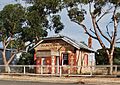
Former Brown's Well District Council chambers, Railway Terrace, Paruna
-
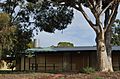
Former Brown's Well District area school
-
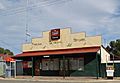
Paruna general store
-
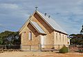
Closed church in High Street, Paruna


