Passyunk Square, Philadelphia facts for kids
Quick facts for kids
Passyunk Square
|
|
|---|---|

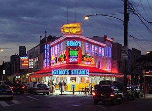
Geno's Steaks at 9th Street and Passyunk in South Philadelphia
|
|
| Country | |
| State | Pennsylvania |
| County | Philadelphia County |
| City | Philadelphia |
| ZIP codes |
19147, 19148
|
| Area code(s) | 215, 267, 445 |
Passyunk Square is a lively neighborhood in South Philadelphia. It's located between Broad Street on the west and 6th Street on the east. To the south, you'll find Tasker Street, and to the north, Washington Avenue.
This area is surrounded by other cool neighborhoods like Bella Vista and Point Breeze. The name "Passyunk" comes from the Lenape people, who were the original inhabitants of this land. In the 1800s, there was a place called Passyunk Township.
A park in the area, originally named Passyunk Square Park, was later called Columbus Square Park. Because of this, the neighborhood itself became known as Columbus Square for a while. However, in 2003, a group of neighbors decided to bring back the original name, Passyunk Square. They formed the Passyunk Square Civic Association to help their community.
Today, Passyunk Square is also known as Little Saigon. This is because many Vietnamese American families and businesses live and operate here. It's one of the biggest Vietnamese communities on the East Coast!
Contents
A Look at Passyunk Square's Past
Passyunk Square has an interesting history. For example, a place called Lafayette Cemetery was started here in 1828. It was located between Federal and Wharton Streets, and 9th and 10th Avenues.
The cemetery was meant to hold about 14,000 bodies. But over time, it became very crowded. By 1946, it held 47,000 bodies and was not well-maintained. The city decided to move all the remains to Evergreen Memorial Park in Bensalem Township.
Today, the land where Lafayette Cemetery once stood is used by the city of Philadelphia as the Capitolo Playground. It's a place for kids to play and have fun.
Learning in Passyunk Square
The School District of Philadelphia provides education for students in this neighborhood. There are two schools for younger students (Kindergarten through 8th grade) that are very important.
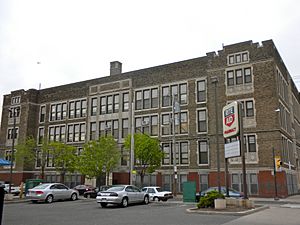
These schools are the Fanny Jackson Coppin School and the Eliza Butler Kirkbride School. Both of these buildings are so historic that they are listed on the National Register of Historic Places. This means they are recognized for their special importance.
Students in this area often go on to attend Furness High School.
A Mix of People in the Neighborhood
Passyunk Square is home to a diverse group of people. Here's a general idea of the different groups living here:
- White - 68%
- Asian - 19%
- Hispanic - 7%
- Black - 6%
This mix of cultures makes the neighborhood a vibrant and interesting place to live.
Shopping and Eating on East Passyunk Avenue
One of the most famous parts of Passyunk Square is the shopping and restaurant area along East Passyunk Avenue. This street is a popular spot for both locals and visitors.
You'll find many unique, privately owned shops here. There are also lots of restaurants where you can try different kinds of food. Besides shops and eateries, East Passyunk Avenue has other useful businesses. These include insurance offices, hair salons, and pharmacies.
A small part of one of America's oldest outdoor markets is also in this area. It's popularly known as The Italian Market. Here, you can find fresh produce, meats, cheeses, and other specialty items.
Getting Around Passyunk Square
It's easy to travel in and out of Passyunk Square. The neighborhood is served by SEPTA, which is Philadelphia's public transportation system.
You can catch the Broad Street Line subway at the Tasker-Morris and Ellsworth-Federal stations. Several SEPTA bus lines also run through the neighborhood. This makes it convenient to explore Passyunk Square and other parts of Philadelphia.


