Patones facts for kids
Quick facts for kids
Patones
|
|||
|---|---|---|---|
|
Rural, educational and hill-sport station
|
|||
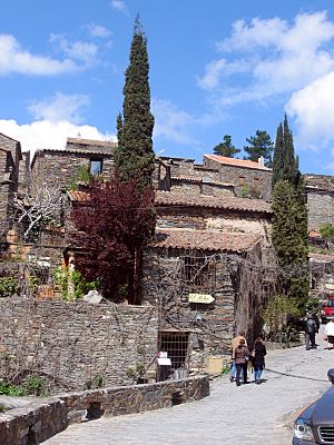
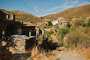
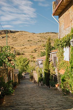
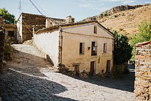
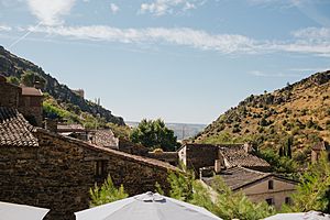
General view of the ancient village (Patones Arriba) with its characteristic slate pavements and buildings
|
|||
|
|||
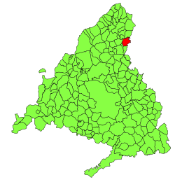
Location of the municipality of Patones within the Community of Madrid
|
|||
| Country | |||
| Region | |||
| Government | |||
| • Type | Mayor–council | ||
| • Body | Ayuntamiento de Patones | ||
| Area | |||
| • Total | 34.5 km2 (13.3 sq mi) | ||
| Elevation | 718 m (2,356 ft) | ||
| Population
(2018)
|
|||
| • Total | 523 | ||
| • Rank | 1st | ||
| Time zone | UTC+2 (CET) | ||
| • Summer (DST) | CEST | ||
| Postal codes in Spain |
28107
|
||
| Area code(s) | 34 (Spain) + 91 (Madrid) | ||
| Patron Saint | Virgen de Patones | ||
| Consists of two settlements: Arriba (upper) Patones – the ancient hillside village known as the Reino de Patones (Kingdom) abandoned in the mid 20th century for Abajo (lower) Patones, a larger modern town on the plain below. | |||
Patones is a small town in Spain, located in the Community of Madrid. It sits partly in the Jarama River valley and partly in the foothills of the Sierra de Guadarrama mountains.
Even though it's small, Patones has its own local government. The town is made up of two different parts: the old village called Patones Arriba (Upper Patones) on a hillside, and the newer town called Patones Abajo (Lower Patones) on the flat land below.
The name "Patones" might come from the family name "Patón," who were believed to be the first people to settle here. They were said to be refugees who created a small Christian "Kingdom of Patones." Another idea is that the name comes from the Latin word patricius.
- Altitude: 834 meters (2,736 feet)
- Area: 35 square kilometers (13.5 square miles)
- Distance from Madrid: 60 kilometers (37 miles)
- Population (in 1999): 368 people
Contents
Patones Abajo: The Modern Town
The area around Patones is important for collecting water. It has large reservoirs and pumping stations that provide drinking water for the city and region of Madrid. These are managed by a company called Canal de Isabel II.
Around the mid-1900s, as cars and other transport became more common, people needed a town that was easier to reach. So, a new settlement was built on the flat land below the old village. This new town was named Patones Abajo, meaning "Lower Patones."
Even though the old village had schools and government buildings that were quite new, new facilities were built in Patones Abajo. Patones Arriba was eventually left empty by the mid-1960s.
In the 1990s, people realized how special the old village was. They also saw its potential for outdoor sports like hiking. So, the old settlement was carefully restored. New places for learning about rural life, cultural tourism, and sports were created. Visitor facilities and short-stay accommodations were also improved.
In 2002, a special center called CENIT was opened. It helps local businesses and people use modern technology and services.
The road to Patones Arriba (M912) is very popular with cyclists. To keep everyone safe and protect the environment, cars are now limited on this road. Since 2011, a free small bus service runs between Patones Abajo and Patones Arriba. This helps tourists and hotel guests get to the old village easily.
Patones Arriba: The Old Village
Patones Arriba existed even before 1527. Records show that its residents were asked to fix a bridge back then.
In a census from 1555, only seven people were recorded living there. In 1687, it became part of the nearby town of Uceda. Around this time, the first mention of a "King of Patones" appeared.
In the 17th century, the village was owned by the Marquise of Ensenada. At one point, it was also owned by the Bishop of Toledo.
The King of Patones: A Unique Story
The "Kings of Patones" were like wise leaders for the village. They acted as both the mayor and the judge. This special system of government lasted until 1750, when the last "king" moved to Madrid.
A writer named Don Antonio Ponz described this role in 1781 in his book Journey around Spain. He wrote about how the people of Patones were believed to be Christian Goths who fled from Muslim invaders long ago. They found a safe place in the mountains and kept their old customs and beliefs. They lived by hunting, fishing, beekeeping, and raising goats.
These people, called Patones, chose a wise person from a good family to lead them and settle their arguments. This leadership became a family tradition, passed down from one generation to the next. They called their leader the "King of the Patones."
It's amazing that this unique government lasted for centuries, even after Spain became free from the Saracens. The last "King of Patones" was known to sell wood in a nearby town. He was a peaceful man who managed the village's affairs without written laws or formal trials.
Eventually, the job of being king became too much for him, and he gave up his role. This left Patones without a leader, and it then came under the control of the Uceda district.
The people of this small "kingdom" lost many of their old special rights. It's said that the Royal Council of Spain used to send official letters directly to the "King of Patones." Even King Fernando VI was curious about this unique kingdom. It was a place that lived in peace for over a thousand years, guided by common sense, and kept its traditions strong, even though it was only a short distance from Madrid.
Places to Explore in Patones
Patones Arriba is special because almost all its buildings are made from black slate. This makes it a great place to learn about old building styles and drystone architecture.
Nature and Landscape Around Patones
The lower part of the area is used for farming. You can see fields of cereals, vineyards, and olive groves stretching up the hills. Along the Jarama River, there are many beautiful trees.
Higher up, you'll find rockrose plants. The northern and eastern slopes are covered with pine forests. Above Patones Arriba, there are old terraces where people used to grow rye. There were also pens for livestock, mostly goats, and sties for pigs. These terraces are now abandoned but are used as paths for hikers. Hunting wild animals here is only allowed with a special license.
Ponton De la Oliva: An Old Reservoir
The Ponton de la Oliva is a reservoir that is no longer used. It was built in 1857 and was the oldest of six reservoirs along the Lozoya River. It was part of a system that supplied drinking water to Madrid.
Canal de Cabarrús: An Ancient Waterway
This irrigation channel was built between the 16th and 18th centuries. It is 13 kilometers (about 8 miles) long. It was the first channel built to bring water from the Lozoya River to the Uceda valley.
The channel passes through Patones and other towns. It originally had six bridges, three aqueducts, and many smaller canals. It was used until the late 1800s. Today, a 1.3-kilometer (0.8-mile) section in Patones is still used, fed by water from another canal and the Atazar Reservoir. This canal is a protected historical site.
The Ermita de la Virgen de la Oliva: A Ruined Hermitage
This hermitage is now a ruin, but it is protected. It was built around the 12th or 13th century for a religious community. It used to be connected to the main church in Alcala de Henares.
Cueva del Reguerillo: A Special Cave
The Cueva del Reguerillo (Reguerillo Cave) is the most important archaeological site in the Community of Madrid. It's interesting for both cave science and caving as a hobby.
Unfortunately, because it was easy to get to and close to Madrid, many people visited the cave without proper care. It became filled with trash and graffiti. So, since 2008, the cave has been closed to the public. This allows scientists to study its archaeology and ancient animal remains.
The cave has three levels, with different difficulties, reaching depths between 78 meters (256 feet) and 9,810 meters (32,185 feet). More details can be found on the Spanish Wikipedia article. In 1974, a 2nd-century Celtic Druid camp was also discovered nearby.
Getting Around Patones: Public Transport
Patones has three bus lines that help people get around:
- Line 197: Connects Madrid (Plaza de Castilla) to Torrelaguna and Uceda. It has two services to Madrid from Monday to Friday, and three on weekends and holidays. It has two services to Uceda from Monday to Friday, and four on weekends and holidays.
- Line 197A: Connects Torrelaguna, Patones, and Uceda. It has one service towards Uceda and two towards Torrelaguna.
- Line 913: Connects Torrelaguna to El Atazar. It has three services on weekends and holidays, and nine daily.
Fun Times: Festivities in Patones
Patones celebrates several traditional festivals throughout the year:
- La Candelaria (February 2)
- Carnival (before Lent, usually in February)
- Saint Joseph's Day (March 19)
- Saint John's Day (June 24/midsummer)
See also
 In Spanish: Patones para niños


