Pearl Falls facts for kids
Quick facts for kids Pearl Falls |
|
|---|---|
 |
|
| Lua error in Module:Infobox_mapframe at line 185: attempt to index field 'wikibase' (a nil value). | |
| Location | Mount Rainier National Park, Pierce County, Washington, United States |
| Coordinates | 46°48′06″N 121°47′58″W / 46.8016°N 121.7994°W |
| Type | Plunge |
| Elevation | 5,739 ft (1,749 m) |
| Total height | 400 ft (120 m) |
| Number of drops | 1 |
| Longest drop | 400 ft (120 m) |
| Total width | 10 ft (3.0 m) |
| Average width | 10 ft (3.0 m) |
| Watercourse | Pearl Creek |
| Average flow rate |
50 cu ft/s (1.4 m3/s) |
| World height ranking | 646 |
Pearl Falls is a tall and beautiful waterfall located in Mount Rainier National Park. This park is in the state of Washington, in the United States. Pearl Falls is one of the highest waterfalls you can find there.
The water for the falls comes from a stream called Pearl Creek. This creek is fed by glaciers, which are like huge, slow-moving rivers of ice. The waterfall appears about halfway along Pearl Creek's journey.
Contents
What Makes Pearl Falls Special?
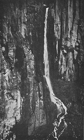
Pearl Falls drops about 400 feet (120 m) (which is about 40 stories high!) from a very steep cliff. This cliff is made of a special type of rock called columnar basalt. This rock forms when lava cools down and cracks into tall, pillar-like shapes.
How the Water Falls
The water plunges almost 200 feet (61 m) straight down without touching the cliff. It lands in a bowl-shaped area that looks a bit like an outdoor theater. This area is similar to the basin at the bottom of Comet Falls, another waterfall nearby.
Near the bottom, the water hits a rock ledge. It then spreads out before dropping straight down again. Finally, it cascades over a pile of loose rocks and continues flowing.
Where to Find It
Pearl Falls is found in a deep, narrow valley. This valley is on the southwest side of Mount Rainier. Mount Rainier is a huge volcano that has erupted many times in the past.
The Journey of Pearl Creek
Pearl Creek is a glacial stream. It flows into another glacial stream called Pyramid Creek. Pyramid Creek then joins Kautz Creek. Finally, Kautz Creek flows into the Nisqually River. This river eventually reaches the ocean. There are also smaller waterfalls and cascades below the main drop of Pearl Falls.
Visiting Pearl Falls
Getting close to Pearl Falls is very difficult. It usually takes at least two days of hiking to reach it safely. The path is steep and challenging.
However, you can see the falls from far away. There is a spot called Ricksecker Point on the Mount Rainier Highway. From there, you can get a distant view of Pearl Falls.
How Pearl Falls Got Its Name
Pearl Falls was named in 1912 by a photographer named Albert Henry Barnes. He was from a city called Tacoma.
Barnes named the falls "Pearl Falls" because of how the water looked. When the light hit the spray from the waterfall just right, it sparkled like many tiny pearls. It is believed that Pearl Creek was then named after the beautiful waterfall.
Other Waterfalls Nearby
Just a few miles to the east of Pearl Falls, you can find another waterfall. This one is called Kautz Creek Falls. It is located on Kautz Creek, which is the same creek that Pearl Creek eventually flows into.
 | Jewel Prestage |
 | Ella Baker |
 | Fannie Lou Hamer |

