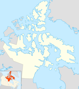
Peary Channel facts for kids
Quick facts for kids Peary Channel |
|
|---|---|
| Location | Nunavut |
| Coordinates | 79°40′00″N 101°29′59″W / 79.66667°N 101.49972°W |
| Part of | Arctic Ocean |
| Ocean/sea sources | Arctic Ocean |
| Basin countries | Canada, Nunavut |
| Max. length | 193 km (120 mi) |
| Max. width | 97 km (60 mi) |
| Frozen | Most of the year |
The Peary Channel is a large waterway located in Nunavut, Canada. It is a part of the Arctic Ocean, stretching out like a long arm of the sea. This channel is found in the very northern parts of Canada. It is about 193 kilometers (120 miles) long and 97 kilometers (60 miles) wide.
Where is the Peary Channel?
The Peary Channel is surrounded by several islands in the Canadian Arctic Archipelago.
- To its north is Meighen Island.
- To the east, you will find Axel Heiberg Island.
- To the south lies Amund Ringnes Island.
- To the west is Ellef Ringnes Island.
This channel acts like a natural passage between these large, icy landmasses.
What is the Peary Channel like?
The Peary Channel is a cold, remote body of water. Because it is so far north, it is frozen for most of the year. This makes it a challenging place to travel, even for modern ships. The channel is part of the vast Arctic Ocean, known for its extreme temperatures and unique wildlife.
See also
 In Spanish: Canal de Peary para niños
 | Madam C. J. Walker |
 | Janet Emerson Bashen |
 | Annie Turnbo Malone |
 | Maggie L. Walker |


