
Pfeiffer Beach facts for kids
Quick facts for kids Pfeiffer Beach |
|
|---|---|

Location in California
|
|
| Location | Big Sur, Monterey County, California |
| Coordinates | 36°14′19″N 121°49′03″W / 36.23861°N 121.81750°W |
| Elevation | 0 m |
| Geology | Franciscan Complex, |
| Age | Cretaceous |
| Topo map | USGS Pfeiffer Point |
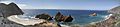
Pfeiffer Beach is a very popular beach in the beautiful Big Sur area of California. It's famous for its amazing Keyhole Rock. This rock has a natural arch that photographers love. In December and January, many people come to take pictures of the sun setting right through the arch! Because the Big Sur coast is so steep, Pfeiffer Beach is one of the few places where you can easily reach the ocean.
Contents
Getting to Pfeiffer Beach
The entrance to Sycamore Canyon Road can be a bit tricky to find. This road is the only way to get to the beach. It's a single-lane road about 2.2 miles (3.5 km) long. Both the road and the beach are inside the Los Padres National Forest. The road is named after the Western Sycamore trees that grow nearby.
Because the road is so narrow, large vehicles like RVs are not allowed. Also, you can't walk on the road. There are only five spots where two cars can pass each other. Many more visitors use the road than local residents.
Parking and Shuttle
The parking lot at the beach can hold 65 cars. It often gets full on summer weekends and holidays. If there's a spot, parking costs $12 per car. During the summer, you can also take a shuttle. This shuttle runs from the US Forest Service office at Big Sur Station to the beach. Once you park, it's just a short walk to the sand.
Some people confuse Pfeiffer Beach with Julia Pfeiffer Burns State Park. That park is located a bit further south.
Purple Sand and Keyhole Rock
This beach is about 1 mile (1.6 km) long. It's famous for patches of purple sand that you can sometimes see. This is especially true after it rains. The purple color comes from a mineral called Manganese garnet. This mineral washes down from the nearby hills.
.jpg)
The most famous feature is Keyhole Rock. It's a large rock formation in the ocean with a natural arch. Many photographers visit to capture the sunset through this arch. This special event only happens on a few days in December and January.
Beach Rules and Safety
Pfeiffer Beach is open from 9:00 a.m. to 8:00 p.m. You are not allowed to camp or have fires on the beach. There are four picnic tables available if you want to eat.
Swimming here can be dangerous. The water is very cold, there are many rocks, and the currents are strong. The weather from June to August can be foggy and cold. Locals call this "June Gloom."
History of the Pfeiffer Family
The Pfeiffer family built the first home in Sycamore Canyon in the winter of 1869. Micheal and Barbara Laquet Pfeiffer were traveling south along the Big Sur coast. They had to stop for the winter in Sycamore Canyon. They loved the area so much that they decided to stay. They did not move south the next spring.
Their eight children grew up and lived in the area for many generations. In 1910, the family opened the Pfeiffer Ranch Resort near their home. An ancient Esslen Native American site is also located near their original home.
Micheal and Barbara's son, John Pfeiffer, and his wife Zulema built a cabin in 1884. This cabin was near the Big Sur River. Pfeiffer Big Sur State Park is named after John. He donated the first 700 acres (280 ha) of land to the state of California. Pfeiffer Beach is also named after this important family.
Images for kids
-
Pfeiffer Beach panorama
