
Pfeifferhorn facts for kids
Quick facts for kids Pfeifferhorn |
|
|---|---|

Pfeifferhorn as seen from the ridge just below and east of the summit
|
|
| Highest point | |
| Elevation | 11,331 ft (3,454 m) NAVD 88 |
| Prominence | 766 ft (233 m) |
| Geography | |

Pfeifferhorn
Location in Utah
|
|
| Location | Salt Lake / Utah counties, Utah, U.S. |
| Parent range | Wasatch Range |
| Topo map | USGS Dromedary Peak |
The Pfeifferhorn is a tall, triangular mountain in the Wasatch Mountains of northern Utah, United States. It stands at 11,331 feet (3,454 m) high. This mountain is in a quiet, isolated part of the Lone Peak Wilderness Area.
Many people call the Pfeifferhorn the Little Matterhorn. This is because its shape reminds them of the famous Matterhorn mountain in Europe. It is the fifth-highest peak in the Wasatch Range. You can reach the top by hiking, but you will need to do some scrambling. Scrambling means using your hands and feet to climb over rocks.
Some people also enjoy rock climbing on the Pfeifferhorn. The north ridge is a very popular route for climbers. In winter, the mountain is a great place for mountaineering adventures.
Contents
Climbing the Pfeifferhorn: Routes and Trails
The Pfeifferhorn is a challenging climb. It is rated as difficult. The total distance to the top and back is about 9.2 miles. Most people need one to two days to complete the trip. The starting point for the hike is around 7,700 feet high.
East Ridge Route via Red Pine Lake
The easiest and most popular way to climb the Pfeifferhorn is by the East Ridge. This route starts from the Red Pine Lake trail in Little Cottonwood Canyon. The trail goes about 3 miles to the lower Red Pine Lake. Then, it is about half a mile more to the upper Red Pine Lake.
From the upper lake, you will climb southwest. You will go up a steep slope made of loose rocks, called talus. This leads to a 'false summit', which looks like the top but isn't the real peak. If there is no snow, you should see a clear trail here.
Keep going west along the ridge. You will pass some large boulders. Then you will reach another steep slope. You can go around this slope to the south and zig-zag up to the summit. This way is easier. Or, you can go straight up the steep slope to the top.
Maybird Gulch Route
Another way to climb the Pfeifferhorn is through Maybird Gulch. To get there, you will find a small footbridge that turns right off the Red Pine Lake trail. This bridge takes you into Maybird.
As you hike, you will pass three small lakes. These lakes are tucked away under the Hogum Divide. The Pfeifferhorn mountain will be right in front of you. After the highest lake, you will enter a large area filled with big rocks. This is a boulder field made of granite talus. It can be hard and slow to cross.
Once you get across the boulder field, you will have a steep scramble to reach the base of the summit. You can even make a loop trip! You could start at Maybird Gulch, climb the peak, and then go down by way of the upper and lower Red Pine lakes. Or, you could do it the other way around.
Gallery
-
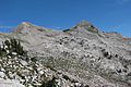
Pfeifferhorn as seen from the south side of the Lone Peak Ridge above the Dry Creek trail
-
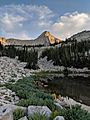
Pfeifferhorn from Maybird Gulch
-
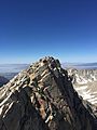
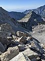
Pfeifferhorn summit
-

Pfeifferhorn panorama
-
Pfeifferhorn in the distance from Mt. Superior
-
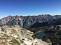
Little Cottonwood ridge line and Red Pine lake from ridge east of the Pfeifferhorn which is the easiest route to the summit.
-
North ridge of Pfeifferhorn


.jpg)


