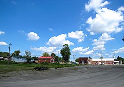
Philadelphia, Tennessee facts for kids
Quick facts for kids
Philadelphia, Tennessee
|
|
|---|---|

Philadelphia, Tennessee
|
|

Location of Philadelphia in Loudon County, Tennessee.
|
|
| Country | United States |
| State | Tennessee |
| County | Loudon |
| Founded | 1822 |
| Incorporated | 1968 |
| Area | |
| • Total | 1.55 sq mi (4.03 km2) |
| • Land | 1.55 sq mi (4.03 km2) |
| • Water | 0.00 sq mi (0.00 km2) |
| Elevation | 879 ft (268 m) |
| Population
(2020)
|
|
| • Total | 607 |
| • Density | 390.35/sq mi (150.71/km2) |
| Time zone | UTC-5 (Eastern (EST)) |
| • Summer (DST) | UTC-4 (EDT) |
| ZIP code |
37846
|
| Area code(s) | 865 |
| FIPS code | 47-57900 |
| GNIS feature ID | 2404511 |
Philadelphia is a small city located in Loudon County, Tennessee, in the United States. It's part of the larger Knoxville area. In 2020, about 607 people lived there.
Contents
History of Philadelphia, Tennessee
Philadelphia was started in the early 1820s by two people named William Knox and Jacob Pearson. The town quickly grew and became an important place for business in the Sweetwater Valley.
Early Growth and Businesses
By the middle of the 1800s, Philadelphia had many useful places. There were two general stores where people could buy almost anything. It also had a tanning yard, which was a place to make leather. A stillhouse and a hotel were also part of the growing town.
Philadelphia During the Civil War
The Civil War affected Philadelphia. On October 20, 1863, soldiers from the Confederate army attacked a Union group here. The Confederates won the fight. They captured about 700 soldiers, 6 cannons, and 50 supply wagons. This event happened after a bigger battle called the Battle of Chickamauga.
Remembering the Past
Many years later, on October 20, 2001, people held a special event. They recreated the battle that happened in 1863. This helped everyone remember the city's history.
Geography of Philadelphia, Tennessee
Philadelphia is located near Sweetwater Creek. This creek flows into Watts Bar Lake, which is part of the Tennessee River. The lake is just a few miles north of the city.
Location and Roads
The main part of Philadelphia is found northwest of where two important roads meet. One road is U.S. Route 11, also known as Lee Highway. This road connects Philadelphia to Loudon in the north and Sweetwater in the south. The other road is State Route 323, or Pond Creek Road. This road leads to Interstate 75 to the west.
Land Area
The city of Philadelphia covers about 1.6 square miles (4.03 square kilometers). All of this area is land, meaning there are no large bodies of water like lakes or rivers within the city limits.
Population and People
The number of people living in Philadelphia has changed over the years. Here's how the population has looked at different times:
| Historical population | |||
|---|---|---|---|
| Census | Pop. | %± | |
| 1880 | 332 | — | |
| 1970 | 554 | — | |
| 1980 | 507 | −8.5% | |
| 1990 | 463 | −8.7% | |
| 2000 | 533 | 15.1% | |
| 2010 | 656 | 23.1% | |
| 2020 | 607 | −7.5% | |
| Sources: | |||
Who Lives in Philadelphia?
The most recent count was in 2020. At that time, 607 people lived in Philadelphia. There were 278 households, which are groups of people living together. Also, 213 families called Philadelphia home.
Racial Makeup of the City
The 2020 census also looked at the different backgrounds of the people in Philadelphia. Most residents, about 80.23%, identified as White (not Hispanic). About 3.79% were Black or African American. A small number, 0.16%, were Native American. About 3.29% were from other backgrounds or mixed races. Finally, 12.52% of the population identified as Hispanic or Latino.
Education in Philadelphia
Students in Philadelphia attend schools that are part of the Loudon County Schools system.
Local Schools
Younger students, from kindergarten up to 8th grade, go to the Philadelphia School. After 8th grade, students attend Loudon High School for grades 9 through 12. Loudon High School is located in the nearby city of Loudon.
See also
 In Spanish: Philadelphia (Tennessee) para niños
 | Percy Lavon Julian |
 | Katherine Johnson |
 | George Washington Carver |
 | Annie Easley |

