Pic a Tenerife facts for kids
Quick facts for kids Pic a Tenerife |
|
|---|---|
 |
|
| Highest point | |
| Elevation | 545 m (1,788 ft) |
| Prominence | 545 m (1,788 ft) |
| Geography | |
| Parent range | Long Range Mountains |
| Topo map | NTS 012/H05 |
| Climbing | |
| Easiest route | class 2 scramble |
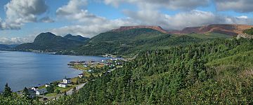
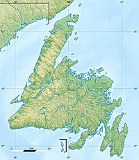
Pic a Tenerife is a mountain located in western Newfoundland, Canada. It stands tall near the coastal town of Glenburnie. This mountain is part of the beautiful Gros Morne National Park.
About Pic a Tenerife
Pic a Tenerife is 545 m (1,788 ft) high. This makes it a noticeable landmark in the area. The mountain is part of the Long Range Mountains range. It offers amazing views of the surrounding landscape.
How Pic a Tenerife Got Its Name
The name Pic a Tenerife has an interesting history. It was given by Captain James Cook in 1767. Captain Cook was a famous British explorer. He named the mountain after the island of Tenerife. This island is located in Spain. It is part of the Canary Islands.
Exploring the Area
Pic a Tenerife is found within Gros Morne National Park. This park is a UNESCO World Heritage Site. It is known for its stunning natural beauty. The park has fjords, waterfalls, and diverse wildlife. Visitors can enjoy hiking, camping, and exploring. The easiest way to climb Pic a Tenerife is by scrambling. This means climbing over rocks and rough terrain.
See also
 In Spanish: Pic a Tenerife para niños


