Pidcock Creek facts for kids
Quick facts for kids Pidcock Creek |
|
|---|---|

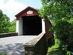
Van Sant Covered Bridge on Pidcock Creek
|
|
|
Pidcock Creek
|
|
| Country | United States |
| State | Pennsylvania |
| County | Bucks |
| Township | Buckingham Upper Makefield Solebury |
| Physical characteristics | |
| Main source | 230 feet (70 m) 40°18′35″N 75°1′57″W / 40.30972°N 75.03250°W |
| River mouth | 49 feet (15 m) 40°19′56″N 74°56′5″W / 40.33222°N 74.93472°W |
| Length | 6.73 miles (10.83 km) |
| Basin features | |
| Progression | Pidcock Creek → Delaware River → Delaware Bay |
| River system | Delaware River |
| Basin size | 12.70 square miles (32.9 km2) |
| Tributaries |
|
| Bridges | Holicong Road Pineville Road Street Road Pidcock Creek Road Atkinson Road (Creek Road) Pennsylvania Route 232 (Windy Bush Road) Covered Bridge Road (Van Sant Covered Bridge) Bowmans Hill Tower Road Pennsylvania Route 32 (River Road) Pennsylvania Canal (Delaware Division) and towpath |
| Slope | 26.89 feet per mile (5.093 m/km) |
Pidcock Creek is a small stream in Bucks County, Pennsylvania. It flows into the big Delaware River. The creek starts in Buckingham Township. It then travels through Upper Makefield Township. Finally, it joins the Delaware River in Solebury Township.
Contents
A Look Back: Pidcock Creek's History
Pidcock Creek got its name from an early settler named John Pidcock. He lived in the area around 1698. In 1701, he bought land near the creek. This land was later called the Thompson-Neely tract.
This area was also home to an old village of the Lenape people. Their village was called Win-na-haw-caw-chunk. This name was mentioned in the old land records.
Pidcock Creek Facts and Figures
Pidcock Creek is officially recognized by the U.S. Geological Survey. It was added to their list of geographic names in 1979. This helps keep track of all the natural features in the country.
The area of land that drains water into Pidcock Creek is called its drainage basin. This basin covers about 12.70 square miles (32.9 km2).
The Path of Pidcock Creek
Pidcock Creek begins in Buckingham Township. It starts from a small pond that doesn't have a name. Soon after it begins, two smaller streams join it. One comes from the left, and one from the right.
The creek then flows into Solebury Township. Here, it turns towards the southeast. A stream called Curls Run joins it from the right side.
Next, Pidcock Creek takes a short trip into Upper Makefield Township. Another stream joins it from the right. After this, the creek goes back into Solebury Township. It then turns east. It makes a curvy "S" shape. Another stream joins it from the right. Finally, Pidcock Creek meets the Delaware River.
Streams Joining Pidcock Creek
Towns and Areas Along the Creek
Pidcock Creek flows through parts of Bucks County. These areas include:
- Solebury Township
- Upper Makefield Township
- Buckingham Township
Bridges Over Pidcock Creek
Many bridges cross Pidcock Creek. They help people and cars get from one side to the other. Here are some of the main crossings:
- Pennsylvania Canal (Delaware Division) - This is a historic canal that runs alongside the creek.
- Pennsylvania Route 32 (River Road) - A bridge on a main road.
- Bowmans Hill Tower Road
- Covered Bridge Road - This road crosses the famous Van Sant Covered Bridge. It's a beautiful old wooden bridge. It was rebuilt in 2008 to keep it safe. This bridge is also listed on the National Register of Historic Places.
- Pennsylvania Route 232 (Windy Bush Road) - Another bridge on a state route.
- Atkinson Road (Creek Road)
- Pidcock Creek Road
- Street Road
- Pineville Road
- Holicong Road
 | Sharif Bey |
 | Hale Woodruff |
 | Richmond Barthé |
 | Purvis Young |


