
Piedra River (Colorado) facts for kids
Quick facts for kids Piedra River |
|
|---|---|

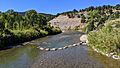
The Piedra River near Arboles
|
|

Piedra River watershed (yellow) within the San Juan River watershed (gray-brown)
|
|
| Physical characteristics | |
| Main source | Confluence of East Fork and Middle Fork 37°26′15″N 107°10′50″W / 37.43750°N 107.18056°W |
| River mouth | Confluence with San Juan 6,089 ft (1,856 m) 37°00′24″N 107°24′06″W / 37.00667°N 107.40167°W |
| Length | 40 mi (64 km) |
| Basin features | |
| Progression | San Juan—Colorado |
| Basin size | 683 sq mi (1,770 km2) |
The Piedra River is a beautiful river in the state of Colorado in the United States. Its name comes from the Spanish word piedra, which means rock. This river flows for about 40 miles (64 kilometers) and helps drain parts of Archuleta, Hinsdale, and Mineral counties.
The Piedra River is known for flowing through deep, narrow canyons. It eventually empties into the San Juan River at Navajo Lake.
Contents
Journey of the Piedra River
The Piedra River begins high up in the San Juan Mountains. It is formed when two smaller rivers, the East Fork and the Middle Fork, join together.
Where the River Starts
- The Middle Fork is the larger of the two starting rivers. It begins in a bowl-shaped valley within the San Juan National Forest. It flows south for about 12.5 miles (20 kilometers) before meeting the East Fork.
- The East Fork starts from a small lake in the Rio Grande National Forest. It flows southwest for about 11 miles (18 kilometers).
Flowing Through Canyons and Valleys
After the East and Middle Forks meet, the Piedra River flows through open meadows. Soon, it drops into a deep canyon. Along its journey, several smaller creeks join the Piedra River. These include O'Neal Creek, Williams Creek, Weimuche Creek, and Sand Creek.
The river then turns southwest. The First Fork Piedra River also joins it from the right. After this, the Piedra River flows more directly south. It receives more water from Heffin Creek and Yellowjacket Creek.
Near Towns and Highways
The Piedra River flows past the town of Piedra. It also goes under U.S. Highway 160. The canyon then widens into a valley. The river continues south-southeast, with Devil Creek joining it from the left. Stollsteimer Creek also joins from the left near Stollsteimer.
The river then turns southwest again, flowing next to State Highway 151.
Meeting the San Juan River
Finally, the Piedra River flows into Navajo Reservoir near the town of Arboles. This is close to the New Mexico state line. The place where the Piedra River meets the San Juan River is now covered by the waters of the reservoir, inside Navajo State Park.

Images for kids
-
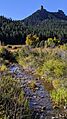
Devil Creek, with Chimney Rock to the south
-
The valley of Stollsteimer Creek
-
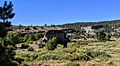
Stollsteimer Creek valley from Chimney Rock Great House
-
Stollsteimer Creek at Old Gallegos Road, Stollsteimer, Colorado, just above its confluence with the Piedra
-
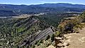
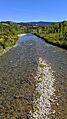
Piedra River at Colorado road 193
-
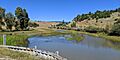
Piedra River just above Navajo Lake, below Colorado Highway 151
-
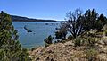
The Piedra River arm of Navajo Lake, at Navajo State Park, Colorado


