Pinehurst, Massachusetts facts for kids
Quick facts for kids
Pinehurst, Massachusetts
|
|
|---|---|

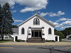
Church of Saint Mary
|
|

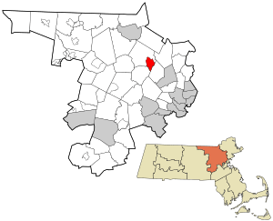
Location in Middlesex County in Massachusetts
|
|
| Country | United States |
| State | Massachusetts |
| County | Middlesex |
| Town | Billerica |
| Area | |
| • Total | 3.77 sq mi (9.76 km2) |
| • Land | 3.73 sq mi (9.66 km2) |
| • Water | 0.04 sq mi (0.10 km2) |
| Elevation | 105 ft (32 m) |
| Population
(2020)
|
|
| • Total | 7,368 |
| • Density | 1,975.34/sq mi (762.77/km2) |
| Time zone | UTC-5 (Eastern (EST)) |
| • Summer (DST) | UTC-4 (EDT) |
| ZIP code |
01866 (PO Boxes Only)
01821 (Billerica) |
| Area code(s) | 978 |
| FIPS code | 25-53680 |
| GNIS feature ID | 0618551 |
Pinehurst is a small community in the town of Billerica, Middlesex County, Massachusetts. It's not a separate town, but a special area called a census-designated place (CDP). This means it has its own name and boundaries for counting people.
In 2020, about 7,368 people lived in Pinehurst. It is located in the southeastern part of Billerica, right along Massachusetts Route 3A. While Pinehurst has its own ZIP code (01866) for post office boxes, most homes and businesses use Billerica's ZIP code (01821) for mail.
Contents
Where is Pinehurst Located?
Pinehurst is found in the eastern part of Middlesex County. Its exact location is 42°32′1″N 71°13′46″W / 42.53361°N 71.22944°W. It shares borders with the towns of Burlington to the southeast and Bedford to the southwest.
The area of Pinehurst stretches west to roads like Wyman Road and Allen Road. To the north, it follows Jones Brook down to the Shawsheen River. The Shawsheen River then flows northeast, forming part of Pinehurst's eastern edge.
Travel Distances from Pinehurst
Using Massachusetts Route 3A (also known as Boston Road), Pinehurst is:
- About 3 miles (5 km) southeast of the center of Billerica.
- About 9 miles (14 km) southeast of Lowell.
- About 15 miles (24 km) northwest of downtown Boston.
Land and Water in Pinehurst
According to the United States Census Bureau, Pinehurst covers a total area of about 3.77 square miles (9.76 square kilometers). Most of this is land, with only a small part, about 0.04 square miles (0.10 square kilometers), being water. The water areas are mainly part of the Shawsheen River. This river is important because it flows into the larger Merrimack River, which eventually reaches the ocean.
What's the Weather Like?
Pinehurst experiences typical New England weather.
- Temperatures usually drop below 50°F (10°C) for about 195 days each year.
- The area gets a lot of rain, with about 45.3 inches (115 cm) of precipitation annually. This is quite high for the United States.
- Snow covers the ground for about 62 days a year, which is about 17% of the year. This is also considered a high amount of snow for the country.
- The humidity is usually below 60% for about 25 days each year.
Who Lives in Pinehurst?
The number of people living in Pinehurst has grown over the years. Here's how the population has changed:
| Historical population | |||
|---|---|---|---|
| Census | Pop. | %± | |
| 1980 | 6,588 | — | |
| 1990 | 6,614 | 0.4% | |
| 2000 | 6,941 | 4.9% | |
| 2010 | 7,152 | 3.0% | |
| 2020 | 7,368 | 3.0% | |
| U.S. Decennial Census | |||
In 2000, there were 6,941 people living in Pinehurst. Most people lived in families.
- About 39.7% of households had children under 18 living with them.
- Most households (70.6%) were married couples.
- The average household had about 3 people.
The median age in Pinehurst in 2000 was 36 years old. This means half the people were younger than 36, and half were older.
See also
 In Spanish: Pinehurst (Massachusetts) para niños
 | Jessica Watkins |
 | Robert Henry Lawrence Jr. |
 | Mae Jemison |
 | Sian Proctor |
 | Guion Bluford |

