Pinson, Alabama facts for kids
Quick facts for kids
Pinson, Alabama
|
|||
|---|---|---|---|

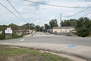
Downtown Pinson
|
|||
|
|||

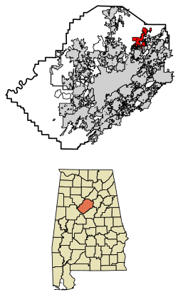
Location of Pinson in Jefferson County, Alabama.
|
|||
| Country | United States | ||
| State | Alabama | ||
| County | Jefferson | ||
| Area | |||
| • Total | 11.59 sq mi (30.02 km2) | ||
| • Land | 11.56 sq mi (29.95 km2) | ||
| • Water | 0.03 sq mi (0.07 km2) | ||
| Elevation | 663 ft (202 m) | ||
| Population
(2020)
|
|||
| • Total | 7,215 | ||
| • Density | 623.97/sq mi (240.91/km2) | ||
| Time zone | UTC-6 (Central (CST)) | ||
| • Summer (DST) | UTC-5 (CDT) | ||
| ZIP code |
35126, 35123, 35215
|
||
| Area code(s) | 205 & 659 | ||
| FIPS code | 01-60648 | ||
| GNIS feature ID | 2424931 | ||
Pinson is a city in Jefferson County, United States. It is located near Birmingham, Alabama, and is northwest of Center Point. In 2020, about 7,215 people lived in Pinson.
Contents
History of Pinson
Pinson became an official city in March 2004. It is a relatively new city.
Geography and Nature
Pinson is located at coordinates 33°41′11″N 86°40′55″W. The city covers an area of about 11.59 square miles (30.02 square kilometers). Most of this area is land, with a small part being water.
Pinson is known for its unique landscape. It has parallel ridges that run from southwest to northeast. You can sometimes see rock outcrops, especially on the eastern side of these ridges.
The city is home to the Turkey Creek Nature Preserve. This is a great place to explore nature. Pinson also hosts the fun Alabama Butterbean Festival. This festival is a popular event in the community.
Within Pinson, you'll find the Palmerdale Homesteads. These were special farming communities. They were built in the 1930s as part of President Franklin Roosevelt's New Deal program. This program helped people during tough economic times. The first homes were ready in 1935. A community store and school were also built to serve the farmers.
Pinson's Climate
Pinson has a humid subtropical climate. This means it has hot, humid summers and mild winters. The average high temperature in July is around 90°F (32°C). In January, the average low is about 31°F (-0.5°C). Pinson gets a good amount of rain throughout the year. Snowfall is very rare.
People of Pinson (Demographics)
| Historical population | |||
|---|---|---|---|
| Census | Pop. | %± | |
| 1990 | 10,987 | — | |
| 2000 | 5,033 | −54.2% | |
| 2010 | 7,163 | 42.3% | |
| 2020 | 7,215 | 0.7% | |
| U.S. Decennial Census 2013 Estimate |
|||
Before Pinson became a city in 2004, its population was counted differently. So, it's hard to know the exact number of people who lived only in the Pinson area in 1990.
Pinson's Population in 2020
In 2020, Pinson had 7,215 residents. There were 2,711 households and 1,997 families living in the city. Most residents were White (about 55%). About 33% were Black or African American. Around 8% of the population was Hispanic or Latino.
Pinson's Population in 2010
In 2010, Pinson had 7,163 people. There were 2,731 households. About 32% of these households had children under 18. Most households (58%) were married couples living together.
The average age in Pinson was 38 years old. About 24% of the population was under 18. Around 12% were 65 or older. The median household income was about $56,863. This means half of the households earned more, and half earned less.
Schools in Pinson
Pinson has several schools for students of different ages:
- Pinson Valley High School – for grades 9 through 12.
- Rudd Middle School – for grades 6 through 8.
- Kermit Johnson Elementary – for grades 3 through 5.
- Pinson Elementary School – for grades Kindergarten through 2.
Local News and Media
If you want to know what's happening in Pinson, you can read these newspapers:
- The Trussville Tribune – a weekly newspaper published on Wednesdays.
- The North Jefferson News – another weekly newspaper, also published on Wednesdays.
- The Birmingham News – a larger newspaper for the whole metro area. It comes out on Wednesdays, Fridays, and Sundays.
Famous People from Pinson
Many interesting people have connections to Pinson:
- Ed Chandler – a former Major League Baseball player.
- William Engesser – an American film actor who was 7'3" tall.
- Samantha Francis – a contestant on America's Next Top Model. She is now an international model.
- Terry Hoeppner – he was an assistant coach at Pinson. Later, he became a head coach for the Indiana University football team.
- Desmond Jennings – another Major League Baseball player.
- Terry Jones – a former outfielder for the Montreal Expos and Colorado Rockies.
- Bo Nix – a Quarterback for the Denver Broncos.
- Melinda Toole – a former Miss Alabama.
- Nico Collins – a wide receiver for the Houston Texans.
See also
 In Spanish: Pinson (Alabama) para niños
 | Roy Wilkins |
 | John Lewis |
 | Linda Carol Brown |


