Piscatawaytown, New Jersey facts for kids
Quick facts for kids
Piscatawaytown, New Jersey
|
|
|---|---|

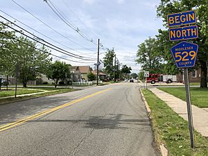
County Route 529 (Plainfield Avenue) in Piscatawaytown, facing north
|
|
| Country | |
| State | |
| County | Middlesex |
| Township | Edison |
| Elevation | 115 ft (35 m) |
| GNIS feature ID | 880876 |
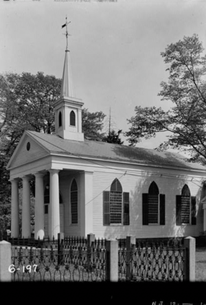
Piscatawaytown is a very old neighborhood located in Edison, New Jersey. It's part of Middlesex County. This area started in the 1660s as the first village in what was then called Piscataway. Today, Piscatawaytown is known for its historic St. James Church, the old burial ground, and the Piscatawaytown Common. These landmarks are found near where Plainfield and Woodbridge Avenues meet.
Contents
How Piscatawaytown Began and Got Its Name
Before European settlers arrived, the Raritan lived here. They were a group of the Lenape people. They lived near the Raritan River and its bay, in what is now central New Jersey and Staten Island, New York.
In the 1600s, people from New England began to settle this area. In 1666, the first governor of New Jersey, Philip Carteret, gave a large piece of land to 12 new settlers. These settlers came from Massachusetts. This land later became the towns of Piscataway and Woodbridge.
Soon after, more settlers arrived from the Piscataqua River area. This river forms part of the border between New Hampshire and Maine. They brought the name "Piscataway" with them. Other early settlements nearby included Quibbletown and Raritan Landing.
Changes to Town Boundaries
Over time, the borders of towns changed. On March 17, 1870, parts of the nearby towns of Piscataway and Woodbridge were used to create a new area called Raritan Township. Later, in the 1950s, Raritan Township was renamed Edison.
Historic Places in Piscatawaytown
In 1695, the leaders of East Jersey set aside land for a burial ground and a town common. This settlement had a town hall, a place for soldiers to train, a fort, a jail, a church, a burial ground, and houses. St. James Church was started in 1704. The first church building was built in 1724. The building you see today was built in 1836.
During the Revolutionary War, there was a lot of fighting in the Piscatawaytown area. This was part of what was called the Forage War in 1776 and 1777. The Post Road, which is now Woodbridge Avenue, was a very important road. The British army used it to send messages, supplies, and soldiers. The British army even used St. James Church as a place for soldiers to stay and as a hospital from December 1776 to June 1777.
In June 1835, a tornado hit the area. It damaged many gravestones and also hurt St. James Church.
The Old Burial Ground
The Piscatawaytown Burial Ground is one of the oldest cemeteries in Middlesex County. The town helps to take care of it.
Some people were buried here even before the land was officially set aside in 1695. One gravestone that can still be read dates back to 1693. The oldest readable gravestone belongs to the Hoopar brothers. They were 10 and 12 years old and died from mushroom poisoning in 1693.
Many soldiers from different wars are buried here. This includes British soldiers who died in the Revolutionary War. They were buried together in a common grave in 1777. The highest-ranking soldier buried here is Brevet Major General Thomas Swords. He fought in the Mexican War and the Civil War. He was buried in 1886.
In 2021, a special scan using ground-penetrating radar was done. It found 98 graves in one part of the burial ground. This area was known as the "colored burial ground." Only 11 of the people buried there have been identified. As of 2015, a total of 1,815 burials have been found in the cemetery. About 1,494 of these have gravestones.
 | Anna J. Cooper |
 | Mary McLeod Bethune |
 | Lillie Mae Bradford |


