Pittsburgh, Atlanta facts for kids
Quick facts for kids |
|
|
Pittsburgh Historic District
|
|
| Location | Roughly bordered by Shelton Ave. Stewart Ave., University Ave., and the RR, Atlanta, Georgia |
|---|---|
| Area | 324 acres (131 ha) |
| Architect | A. Ten Eyck Brown |
| Architectural style | Tudor Revival, Bungalow/Craftsman |
| NRHP reference No. | 06000503 |
| Added to NRHP | June 14, 2006 |
|
Pittsburgh, Atlanta
|
|
|---|---|
|
Neighborhoods of Atlanta
|
|

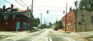
McDaniel Street in Pittsburgh
|
|

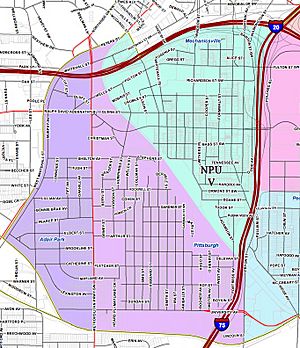
Pittsburgh (light purple) within southwest Atlanta
|
|
| Country | United States |
| State | Georgia |
| County | Fulton County |
| City | City of Atlanta |
| NPU | V |
| Population
(2000)
|
|
| • Total | 3,286 |
| ZIP Code |
30310
|
| Website | Pittsburgh Community Improvement Association |
Pittsburgh is a neighborhood in Atlanta, Georgia. It was started in 1883. The area was named Pittsburgh because its factories and industrial feel reminded people of Pittsburgh, Pennsylvania, which is famous for its steel mills.
Pittsburgh is a neighborhood that has been growing and changing. As property values increase in nearby areas of Atlanta, many hope this will bring new life and improvements to Pittsburgh. This trend could also help the people who have lived there for a long time.
Contents
Where is Pittsburgh Located?
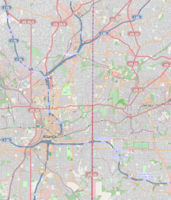
Pittsburgh is located in southwest Atlanta. It has clear borders that help define it.
- To the north, it is next to I-20. Across the highway is Castleberry Hill.
- To the northeast, a train line separates it from Mechanicsville.
- On the west side, you'll find Metropolitan Parkway and the Adair Park neighborhood.
- To the east, it borders Peoplestown.
- The southern edge is marked by the BeltLine, with the Capital View Manor neighborhood beyond it.
Even though Pittsburgh and Mechanicsville share some street names, a railway line keeps them mostly separate. You can only connect between them at their northeast and west edges.
Pittsburgh is also very convenient for getting around. It's close to I-75 and you can walk to downtown Atlanta. Other nearby places include the West End Mall, Grant Park, and the Atlanta Zoo. Several major roads from downtown lead right into Pittsburgh.
You can also easily reach Pittsburgh by public transport. The Garnett, West End, and Oakland City MARTA train stations are all within walking distance.
The Story of Pittsburgh
The area we now call Pittsburgh began to have houses built in the early 1880s. At that time, it was on the southern edge of Atlanta. A white real estate investor named H.L. Wilson owned the land.
Pittsburgh was similar to the nearby neighborhood of Mechanicsville. Both areas grew because of the Pegram railroad repair shops. However, Pittsburgh was mainly a community for African-American families.
Early Days of Pittsburgh
Pittsburgh was a community where many working-class Black families lived. It had good transportation with four streetcar lines. These lines ran along Washington Street, Pryor Street, Stewart Avenue (now Metropolitan Parkway), and Georgia Avenue (now Ralph David Abernathy Boulevard).
Even with challenges, early Pittsburgh had many educated and independent residents. Until the 1930s, Clark College was located here. There were also two theological seminaries, which are schools for religious studies. Black-owned businesses also started to open on McDaniel Street.
Changes Over Time
Starting in the 1960s, African-American families who were doing well could move into areas that were previously only for white residents. Many did so. At the same time, many white families began moving out to the suburbs.
Pittsburgh also faced a lack of new public and private investments. This caused the value of homes in Pittsburgh to go down. Eventually, many houses became empty. The number of people living in Pittsburgh dropped by half, from 7,276 in 1970 to 3,624 in 1990.
The population started to increase in the early 2000s. However, it dropped again during the economic downturn around 2008-2009. Since 2012, the population has been growing again. More money is also being invested in the community.
Pittsburgh Today
In the early 2000s, more middle and upper-income people started moving back into many parts of Atlanta. This gave hope to many in Pittsburgh that their neighborhood would also get new investments. They hoped this would happen without pushing out the current residents, as had happened in places like Cabbagetown.
While big changes haven't happened everywhere yet, there are signs of new growth. For example, the Pittsburgh Civic League Apartments, which were low-income housing, were replaced with a large new apartment complex.
The BeltLine runs along the southern border of Pittsburgh. This project will add new park areas and a bicycle path. There are also plans for a light rail system with a stop near University and Metropolitan Avenues. This could bring even more new development to the area.
Since 2012, neighborhoods along the southwest BeltLine trail have seen a lot of new interest. This includes areas like Adair Park, Summerhill, West End, and Mechanicsville. This makes it very likely that Pittsburgh will also see similar growth. The goal is to make sure that long-time residents also benefit from these new resources and investments.
Community Improvements
One important issue in Pittsburgh and nearby areas is "brownfields." These are pieces of land that might have been used for industry and need to be cleaned up. One of the largest brownfields is a 31.4-acre site along University Avenue. This land is very important because it's at the southern entrance to the neighborhood.
In 2001, UPS bought this brownfield for a distribution center. But their plans changed, and in 2006, they sold it to the Annie E. Casey Foundation. This foundation plans to build a park and a mixed-use development, which means buildings with different uses like homes and shops.
The Annie E. Casey Foundation started working with the community to create a Master Plan for the area. This plan has been ongoing, especially after the economic downturn in 2008. Groups like SDNSI have helped create guiding documents. They worked with the Annie E. Casey Foundation, BeltLine, Inc., the Pittsburgh Community Improvement Corporation, the City of Atlanta, and local residents.
The new Master Plan suggests that the University Avenue lot should have high-density buildings, parks, and new roads connecting Pittsburgh to other neighborhoods. There is also new interest in cleaning up other brownfields in the area. This includes a site on the north end of Pittsburgh that used to be covered with tires. Federal money has been provided for these cleanups.
Shopping and Businesses
Metropolitan Parkway forms the western border of Pittsburgh. This road is an important area for businesses and shops. On the eastern side of Pittsburgh, next to Peoplestown, there is also a small area with businesses and factories.
Historically, McDaniel Street was the main street for businesses in Pittsburgh. However, this area needs some improvements and new businesses to thrive again.
Education
Children in the Pittsburgh community attend schools managed by Atlanta Public Schools. There is also a Salvation Army Center for Officer Training located in Pittsburgh.
Parks
Pittman Park is a green space located within the Pittsburgh neighborhood. It offers a place for residents to relax and enjoy the outdoors.
 | John T. Biggers |
 | Thomas Blackshear |
 | Mark Bradford |
 | Beverly Buchanan |


