
Pleasantville, New Jersey facts for kids
Quick facts for kids
Pleasantville, New Jersey
|
||
|---|---|---|
|
City
|
||
_just_south_of_U.S._Route_40_and_U.S._Route_322_(Black_Horse_Pike)_in_Pleasantville,_Atlantic_County,_New_Jersey.jpg)
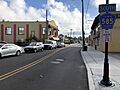
Downtown Pleasantville along southbound CR 585 (Main Street)
|
||
|
||

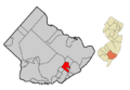
Map of Pleasantville in Atlantic County. Inset: Location of Atlantic County highlighted in New Jersey.
|
||

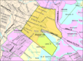
Census Bureau map of Pleasantville, New Jersey
|
||

Pleasantville, New Jersey
Location in Atlantic County, New Jersey

Pleasantville, New Jersey
Location in New Jersey

Pleasantville, New Jersey
Location in the United States
|
||
| Country | ||
| State | ||
| County | Atlantic | |
| Incorporated | January 10, 1889 | |
| Government | ||
| • Type | City | |
| • Body | City Council | |
| Area | ||
| • Total | 7.28 sq mi (18.86 km2) | |
| • Land | 5.72 sq mi (14.82 km2) | |
| • Water | 1.56 sq mi (4.05 km2) 21.46% | |
| Area rank | 238th of 565 in state 16th of 23 in county |
|
| Elevation | 7 ft (2 m) | |
| Population
(2020)
|
||
| • Total | 20,629 | |
| • Estimate
(2023)
|
20,613 | |
| • Rank | 133rd of 565 in state 5th of 23 in county |
|
| • Density | 3,605.8/sq mi (1,392.2/km2) | |
| • Density rank | 186th of 565 in state 3rd of 23 in county |
|
| Time zone | UTC−05:00 (Eastern (EST)) | |
| • Summer (DST) | UTC−04:00 (Eastern (EDT)) | |
| ZIP Codes |
08232
|
|
| Area code | 609 | |
| FIPS code | 3400159640 | |
| GNIS feature ID | 0885356 | |
| Website | ||

Pleasantville is a city located in Atlantic County, New Jersey. It is part of the South Jersey region. In 2020, the city's population was 20,629. This was the highest number of people living there ever recorded in a census.
Pleasantville started as a borough on January 10, 1889. It was formed from parts of Egg Harbor Township. Later, on April 14, 1914, it officially became a city. The city was named by David Ingersoll, who found the area very pleasant.
Contents
Geography and Location
Pleasantville covers an area of about 7.28 square miles (18.86 km²). Most of this area is land, with some water. The city is near several other towns in Atlantic County. These include Absecon, Atlantic City, Egg Harbor Township, Northfield, and Ventnor City.
Population Changes in Pleasantville
| Historical population | |||
|---|---|---|---|
| Census | Pop. | %± | |
| 1900 | 2,182 | — | |
| 1910 | 4,390 | 101.2% | |
| 1920 | 5,887 | 34.1% | |
| 1930 | 11,580 | 96.7% | |
| 1940 | 11,050 | −4.6% | |
| 1950 | 11,938 | 8.0% | |
| 1960 | 15,172 | 27.1% | |
| 1970 | 14,007 | −7.7% | |
| 1980 | 13,435 | −4.1% | |
| 1990 | 16,027 | 19.3% | |
| 2000 | 19,012 | 18.6% | |
| 2010 | 20,249 | 6.5% | |
| 2020 | 20,629 | 1.9% | |
| 2023 (est.) | 20,613 | 1.8% | |
| Population sources: 1900–2000 1900–1920 1900–1910 1900–1930 1940–2000 2000 2010 2020 |
|||
The population of Pleasantville has grown over the years. In 2000, about 19,000 people lived here. By 2010, the population increased to over 20,000. The latest census in 2020 showed a slight increase to 20,629 residents.
Who Lives in Pleasantville?
In 2020, the city's population was diverse. About half of the residents identified as Hispanic or Latino. Other large groups included Black or African American residents and White residents. There are also smaller groups of Asian and Native American residents.
The average age in Pleasantville in 2010 was 33 years old. About 27.5% of the population was under 18.
Economy and Business
Pleasantville is part of an Urban Enterprise Zone (UEZ). This program helps encourage businesses to open and grow in the city. It offers benefits like a reduced sales tax rate. Shoppers in the UEZ pay half the normal state sales tax. This helps to create jobs and bring money into the community. Pleasantville became a UEZ in 1994, and its status will continue until March 2026.
Sports History
Pleasantville has a cool sports history! In 1945, the Boston Red Sox baseball team held their spring training here. This happened because of travel rules during World War II. They even played exhibition games against the New York Yankees.
The city was also home to Laoma Byrd's Gym. This gym was famous for boxing from the 1940s to the 1960s. Many well-known boxers trained there. These included Ezzard Charles, Jersey Joe Walcott, and Sonny Liston.
Parks and Outdoor Activities
Part of an old railroad track in Pleasantville has been turned into a bike path. This path is called the Somers Point Bike Path. It stretches for about 6 miles (9.7 km) between Pleasantville and Somers Point. It is a great place for biking and walking.
Education in Pleasantville
Students in Pleasantville attend schools run by the Pleasantville Public Schools district. This district serves students from pre-kindergarten all the way through twelfth grade. There are six schools in the district.
- Decatur Avenue Early Childhood Center (PreK)
- Leeds Avenue School (PreK-5)
- North Main Street School (PreK-5)
- South Main Street School (PreK-5)
- Washington Avenue School (K-5)
- Pleasantville Middle School (grades 6-8)
- Pleasantville High School (grades 9-12)
Students from Absecon also attend Pleasantville High School. This is part of a special agreement between the two towns.
Students can also choose to go to other schools. These include the Atlantic County Institute of Technology or the Charter-Tech High School for the Performing Arts.
Getting Around Pleasantville
_from_the_overpass_for_Linden_Avenue_in_Pleasantville,_Atlantic_County,_New_Jersey.jpg)
Pleasantville has many roads and highways. Major roads that pass through the city include U.S. Route 9, U.S. Route 40, U.S. Route 322, and the Atlantic City Expressway.
Public Transportation Options

NJ Transit provides bus services in Pleasantville. These buses connect the city to Atlantic City, New Jersey and other nearby towns. In the past, there was also an electric train service called the Atlantic City and Shore Railroad. It ran from 1907 to 1948.
Famous People from Pleasantville
Many notable people have connections to Pleasantville.
- Nia Ali (born 1988) is a track and field athlete. She is known for the 100-meter hurdles.
- Ellen Bass (born 1947) is a poet and author.
- Sonora Webster Carver (1904–2003) was famous as the first female horse diver.
- Walter Evans Edge (1873–1956) was a politician. He served as a U.S. Senator and Governor of New Jersey.
- Rodney Jerkins (born 1977) is a Grammy Award-winning songwriter and music producer.
- Simon Lake (1866–1945) was an engineer who worked on submarines.
- Max Manning (1918–2003) was a pitcher in Negro league baseball.
- Bette Nash (c. 1936–2024) was the longest-serving flight attendant in the world.
- Jay Versace (born 1998) is a Grammy Award-winning record producer and former internet personality.
Images for kids
-
Downtown Pleasantville along southbound CR 585 (Main Street)
-

Pleasantville City Logo
-
Map of Pleasantville in Atlantic County
-
Census Bureau map of Pleasantville, New Jersey
See also
 In Spanish: Pleasantville (Nueva Jersey) para niños
