Plumstead Township, Pennsylvania facts for kids
Quick facts for kids
Plumstead Township
|
||
|---|---|---|
|
Township
|
||
| Plumstead Township | ||

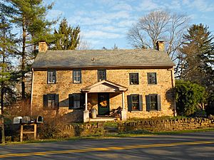
House in the Dyerstown Historic District
|
||
|
||

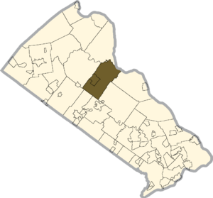
Location of Plumstead Township in Bucks County
|
||
| Country | United States | |
| State | Pennsylvania | |
| County | Bucks | |
| Area | ||
| • Total | 27.28 sq mi (70.7 km2) | |
| • Land | 27.16 sq mi (70.3 km2) | |
| • Water | 0.12 sq mi (0.3 km2) | |
| Elevation | 394 ft (120 m) | |
| Population
(2020)
|
||
| • Total | 14,021 | |
| • Density | 513.97/sq mi (198.44/km2) | |
| Time zone | UTC-5 (EST) | |
| • Summer (DST) | UTC-4 (EDT) | |
| Area codes | 215, 267 and 445 | |
| FIPS code | 42-017-61616 | |
Plumstead Township is a community in Bucks County, Pennsylvania, United States. It's called a "township," which is a type of local government area. In 2020, about 14,021 people lived there.
Contents
History of Plumstead
Plumstead Township was settled a long time ago, in the early 1700s. People called Quakers, who wanted to practice their religion freely, were among the first to move here. By 1725, the area was officially recognized as Plumstead Township.
A famous group known as the Doan Outlaws grew up in Plumstead. They were involved in some criminal activities during the American Revolutionary War.
You can find several historic places in Plumstead Township. These include the Gardenville-North Branch Rural Historic District, the Dyerstown Historic District, and the Loux Covered Bridge. These spots are so important that they are listed on the National Register of Historic Places.
Geography of Plumstead
Plumstead Township covers about 27.2 square miles (70.5 square kilometers). Most of this area is land, with a small part being water. The township is connected to the Delaware River, which forms its eastern border and separates it from New Jersey.
Many small villages and communities are part of Plumstead Township. Some of these include Danboro, Dyerstown, Fountainville, Gardenville, and Plumsteadville.
Ralph Stover State Park, a beautiful place for outdoor activities, is partly located in Plumstead Township.
The area also has many natural features like streams and hills. Some of these are Cabin Run, Curley Hill, and Tohickon Creek.
Neighboring Communities
Plumstead Township shares its borders with several other townships and one New Jersey community:
- Solebury Township (to the east)
- Buckingham Township (to the southeast)
- Doylestown Township (to the south)
- New Britain Township (to the southwest)
- Hilltown Township (to the southwest)
- Bedminster Township (to the northwest)
- Tinicum Township (to the north)
- Kingwood Township, New Jersey (to the northeast)
Population Information
| Historical population | |||
|---|---|---|---|
| Census | Pop. | %± | |
| 1930 | 2,080 | — | |
| 1940 | 2,168 | 4.2% | |
| 1950 | 2,353 | 8.5% | |
| 1960 | 3,354 | 42.5% | |
| 1970 | 4,682 | 39.6% | |
| 1980 | 5,153 | 10.1% | |
| 1990 | 6,289 | 22.0% | |
| 2000 | 11,409 | 81.4% | |
| 2010 | 12,442 | 9.1% | |
| 2020 | 14,021 | 12.7% | |
The population of Plumstead Township has grown quite a bit over the years. In 2010, most residents were White (94.1%). There were also smaller percentages of Black or African American, Native American, and Asian residents. About 4.7% of the people identified as Hispanic or Latino.
Climate and Weather
Plumstead Township has a climate known as a "humid continental climate." This means it has hot summers and gets rain throughout the year.
During summer, it can get very hot and humid. The "heat index" (what the temperature feels like to your body) can sometimes reach 100 degrees Fahrenheit (38 degrees Celsius) or higher. July is usually the wettest month, with many thunderstorms.
In winter, it can get very cold and windy. The "wind chill" (how cold it feels due to wind) can drop below 0 degrees Fahrenheit (-18 degrees Celsius). The average yearly low temperature is about -2.7 degrees Fahrenheit (-19.3 degrees Celsius). Plumstead Township usually gets between 30 and 36 inches (76 to 91 centimeters) of snow each winter. February is often the snowiest month.
| Climate data for Plumstead Township, Bucks County, Pennsylvania (1981 – 2010 averages) | |||||||||||||
|---|---|---|---|---|---|---|---|---|---|---|---|---|---|
| Month | Jan | Feb | Mar | Apr | May | Jun | Jul | Aug | Sep | Oct | Nov | Dec | Year |
| Mean daily maximum °F (°C) | 38.1 (3.4) |
41.5 (5.3) |
49.9 (9.9) |
62.0 (16.7) |
71.9 (22.2) |
80.6 (27.0) |
84.8 (29.3) |
83.0 (28.3) |
76.1 (24.5) |
64.8 (18.2) |
53.8 (12.1) |
42.4 (5.8) |
62.5 (16.9) |
| Daily mean °F (°C) | 29.4 (−1.4) |
32.2 (0.1) |
39.8 (4.3) |
50.7 (10.4) |
60.4 (15.8) |
69.6 (20.9) |
74.1 (23.4) |
72.5 (22.5) |
65.1 (18.4) |
53.6 (12.0) |
43.9 (6.6) |
33.9 (1.1) |
52.2 (11.2) |
| Mean daily minimum °F (°C) | 20.7 (−6.3) |
22.9 (−5.1) |
29.7 (−1.3) |
39.4 (4.1) |
49.0 (9.4) |
58.6 (14.8) |
63.4 (17.4) |
62.0 (16.7) |
54.2 (12.3) |
42.4 (5.8) |
34.0 (1.1) |
25.5 (−3.6) |
41.9 (5.5) |
| Average precipitation inches (mm) | 3.38 (86) |
2.74 (70) |
3.84 (98) |
4.05 (103) |
4.33 (110) |
4.37 (111) |
5.03 (128) |
4.04 (103) |
4.50 (114) |
4.26 (108) |
3.72 (94) |
4.01 (102) |
48.27 (1,226) |
| Average relative humidity (%) | 67.9 | 64.3 | 59.9 | 58.8 | 63.4 | 68.8 | 68.3 | 71.1 | 72.7 | 70.9 | 69.9 | 69.6 | 67.1 |
| Average dew point °F (°C) | 20.1 (−6.6) |
21.5 (−5.8) |
27.0 (−2.8) |
36.8 (2.7) |
47.9 (8.8) |
58.9 (14.9) |
63.0 (17.2) |
62.6 (17.0) |
56.1 (13.4) |
44.4 (6.9) |
34.7 (1.5) |
25.0 (−3.9) |
41.6 (5.3) |
| Source: PRISM Climate Group | |||||||||||||
Transportation in Plumstead
Plumstead Township has over 111 miles (179 kilometers) of public roads. Some roads are kept up by the Pennsylvania Department of Transportation (PennDOT), and others are maintained by the township itself.
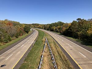
The most important highway in Plumstead Township is Pennsylvania Route 611. It runs from south to north through the southwestern part of the township. Other state highways include Pennsylvania Route 32, Pennsylvania Route 313, and Pennsylvania Route 413.
Public transportation is also available. SEPTA provides bus service to the Cross Keys Place shopping center. From there, you can take a bus to nearby towns like Doylestown and Willow Grove. Bucks County Transport also runs a local bus service called the Doylestown DART that serves the Cross Keys Place shopping center and goes into Doylestown.
Ecology and Nature
The natural plant life in Plumstead Township is mostly made up of Oak trees. This type of forest is called an Eastern Hardwood Forest. It means you'll find many different kinds of trees with broad leaves that change color in the fall.
Culture and Community
Every year, starting in early June, the Plumsteadville Grange Farm Market opens. This market is a great place to find fresh local produce, delicious baked goods, and handmade items from local sellers. It stays open until the end of October.
Notable People
- Doan Outlaws
See also
 In Spanish: Municipio de Plumstead para niños


