
Pocahontas, Missouri facts for kids
Quick facts for kids
Pocahontas, Missouri
|
|
|---|---|

Pocahontas at dusk
|
|

Location of Pocahontas, Missouri
|
|
| Country | United States |
| State | Missouri |
| County | Cape Girardeau |
| Area | |
| • Total | 0.10 sq mi (0.27 km2) |
| • Land | 0.10 sq mi (0.27 km2) |
| • Water | 0.00 sq mi (0.00 km2) |
| Elevation | 584 ft (178 m) |
| Population
(2020)
|
|
| • Total | 97 |
| • Density | 941.75/sq mi (363.72/km2) |
| Time zone | UTC-6 (Central (CST)) |
| • Summer (DST) | UTC-5 (CDT) |
| ZIP code |
63779
|
| Area code(s) | 573 |
| FIPS code | 29-58628 |
| GNIS feature ID | 724682 |
Pocahontas is a small village in Cape Girardeau County, Missouri, in the United States. It's a quiet place with a population of 97 people, according to the 2020 census. It is part of the larger Cape Girardeau area.
Contents
Why is it Called Pocahontas?
The village of Pocahontas has an interesting story behind its name! Long ago, a man named Samuel Green opened a post office and started the town. He needed to give the new town a name.
Samuel Green had met a princess from the Shawnee and Delaware tribes. These tribes lived near Apple Creek. When the tribes moved west, the princess left too. Green wanted to name the town after her.
However, her name was very hard to say and spell. So, Samuel Green decided to use the name of the famous historic Indian princess, Pocahontas. She was well-known from colonial Virginia.
Another story says the town was named to honor Joseph Abernathy. He was said to be a descendant of the original Pocahontas. He moved to Missouri very early on.
History of Pocahontas
The land where Pocahontas now stands has a long history.
Early Inhabitants
The first people in this area were the Mississippian Mound Builders. They were part of the Mississippian culture. These ancient people built large mounds. Around the 12th and 13th centuries, their culture began to decline. This led to fewer people living in the area for a while.
Later, in the late 1700s, French and Spanish officials allowed Shawnee and Delaware Native Americans to move here. They came from Ohio. By the 1820s, most of these tribes moved further west. Only a few stayed behind. The last Native Americans left the area in 1857.
Settlers and Growth
Early American families, like the Abernathys and Littles, settled here. They farmed the land around what is now Pocahontas. Samuel Green, who was from England, bought land from Joseph Abernathy. He opened a general store and a post office called Green Station.
The Applecreek Presbyterian Church was started in 1821. It celebrated its 200th anniversary in 2021. Later, German and Austrian immigrants began to settle near Pocahontas. St. John Iowa Synod Lutheran Church was founded in 1870. Zion Lutheran Church Missouri Synod was built in 1889.
Pocahontas officially became a town in 1893. A flour mill was built by John Hatcher. Today, this mill is still running as the Bowman Milling Company. The town also established a public school and two Lutheran church schools. In 2015, Pocahontas had four stores, several shops, a planing mill, and a lumber yard.
Geography of Pocahontas
Pocahontas is located in the northern part of Cape Girardeau County. It is about thirteen miles north-northeast of Cape Girardeau. It is also seven miles west of Neelys Landing, which is on the Mississippi River.
U.S. Route 61 passes about one mile west of the village. The village sits between the beginnings of Blue Shawnee Creek and Muddy Shawnee Creek.
The United States Census Bureau states that the village covers a total area of 0.10 square miles (0.27 square kilometers). All of this area is land.
Population Information
| Historical population | |||
|---|---|---|---|
| Census | Pop. | %± | |
| 1880 | 47 | — | |
| 1900 | 100 | — | |
| 1910 | 125 | 25.0% | |
| 1920 | 156 | 24.8% | |
| 1930 | 115 | −26.3% | |
| 1940 | 119 | 3.5% | |
| 1950 | 130 | 9.2% | |
| 1960 | 128 | −1.5% | |
| 1970 | 127 | −0.8% | |
| 1980 | 130 | 2.4% | |
| 1990 | 90 | −30.8% | |
| 2000 | 127 | 41.1% | |
| 2010 | 114 | −10.2% | |
| 2020 | 97 | −14.9% | |
| U.S. Decennial Census 2020 | |||
The population of Pocahontas changes over time. In 2010, there were 114 people living in the village. This means there were about 1,140 people for every square mile. Most of the people living in Pocahontas were White (99.12%).
The average age of people in the village in 2010 was 41 years old. About 22.8% of the residents were under 18 years old.
Education
Students in Pocahontas attend schools in the Jackson R-2 School District. This district also operates Jackson High School.
Photo gallery
-
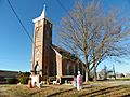
Zion Lutheran Church, Missouri Synod
-
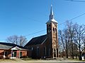
St. John's Evangelical Lutheran Church
-
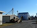
Pocahontas Feed Mill
-
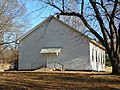
Apple Creek Presbyterian Church


See also
 In Spanish: Pocahontas (Misuri) para niños
