Pohatcong Mountain facts for kids
Quick facts for kids Pohatcong Mountain |
|
|---|---|
| Highest point | |
| Elevation | 866 ft (264 m) |
| Listing | List of mountains of the United States |
| Geography | |
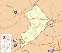
| Location | Warren County, New Jersey, United States |
| Parent range | Appalachian Mountains |
| Topo map | USGS Bloomsbury |
Pohatcong Mountain is a long, narrow hill, also known as a ridge, located in the northwestern part of New Jersey, United States. It's part of the larger Appalachian Mountains range. This mountain stretches for about 6 miles (10 kilometers).
What is Pohatcong Mountain?
Pohatcong Mountain is a natural landform that looks like a long, raised line of hills. It's about 800 feet (244 meters) high along most of its length. This makes it a noticeable feature in the landscape of Warren County, New Jersey.
Where is it Located?
The mountain starts near the town of Phillipsburg in the west. From there, it goes northeast towards Allamuchy Township, New Jersey. Interestingly, this ridge doesn't just stop there! It continues further north past Washington. This northern part is sometimes called Upper Pohatcong Mountain. Sometimes, people use "Pohatcong Mountain" to talk about both parts together.
Water Around the Mountain
Mountains often play a big role in how water flows across the land. Pohatcong Mountain acts like a natural divider for water. On its northwestern side, the water flows into Pohatcong Creek. On its southeastern side, the water flows into the Musconetcong River. These areas where water collects and flows into a specific river or creek are called watersheds. So, the mountain helps separate these two important watersheds.
 | Mary Eliza Mahoney |
 | Susie King Taylor |
 | Ida Gray |
 | Eliza Ann Grier |


