Pollock Pines, California facts for kids
Quick facts for kids
Pollock Pines, California
|
|
|---|---|

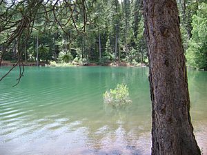
Jenkinson Lake near Pollock Pines
|
|

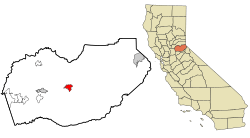
Location in El Dorado County and the state of California
|
|
| Country | |
| State | |
| County | El Dorado |
| Area | |
| • Total | 7.960 sq mi (20.617 km2) |
| • Land | 7.928 sq mi (20.533 km2) |
| • Water | 0.032 sq mi (0.084 km2) 0.4% |
| Elevation | 3,980 ft (1,213 m) |
| Population
(2020)
|
|
| • Total | 7,112 |
| • Density | 893.47/sq mi (344.96/km2) |
| Time zone | UTC-8 (Pacific (PST)) |
| • Summer (DST) | UTC-7 (PDT) |
| ZIP code |
95726
|
| Area code(s) | 530 |
| FIPS code | 06-58030 |
| GNIS feature ID | 1659419 |
Pollock Pines is a small community in El Dorado County, California, United States. It's located high up in the Sierra Nevada mountains. In 2020, about 7,112 people lived there.
Contents
Exploring Pollock Pines' Location
Pollock Pines is found on the western side of the Sierra Nevada mountains. It gets a lot of snow each year, from 6 inches to 6 feet! The area is mostly land, covering about 8 square miles (20.7 square kilometers).
The town is in a heavily forested mountain area. It sits on a ridge south of the South Fork of the American River. Because of all the trees, it's known as a "very high fire hazard severity zone."
Pollock Pines is about 13 miles (21 km) east of Placerville. It's also about 58 miles (93 km) east of Sacramento. You can reach it easily by taking U.S. Highway 50.
Pollock Pines' Climate
Pollock Pines has a climate known as a "warm-summer Mediterranean climate." This means it has hot, dry summers and mild, wet winters.
| Climate data for Pollock Pines, California | |||||||||||||
|---|---|---|---|---|---|---|---|---|---|---|---|---|---|
| Month | Jan | Feb | Mar | Apr | May | Jun | Jul | Aug | Sep | Oct | Nov | Dec | Year |
| Record high °F (°C) | 73 (23) |
78 (26) |
82 (28) |
90 (32) |
95 (35) |
100 (38) |
103 (39) |
105 (41) |
108 (42) |
98 (37) |
84 (29) |
80 (27) |
108 (42) |
| Mean daily maximum °F (°C) | 46.6 (8.1) |
50.9 (10.5) |
55.7 (13.2) |
64.3 (17.9) |
71.5 (21.9) |
83.0 (28.3) |
90.7 (32.6) |
90.5 (32.5) |
84.0 (28.9) |
70.7 (21.5) |
53.5 (11.9) |
45.8 (7.7) |
67.3 (19.6) |
| Mean daily minimum °F (°C) | 31.3 (−0.4) |
30.0 (−1.1) |
33.5 (0.8) |
36.4 (2.4) |
42.0 (5.6) |
49.0 (9.4) |
55.3 (12.9) |
54.3 (12.4) |
50.2 (10.1) |
41.7 (5.4) |
34.6 (1.4) |
30.0 (−1.1) |
40.7 (4.8) |
| Record low °F (°C) | 10 (−12) |
12 (−11) |
14 (−10) |
18 (−8) |
27 (−3) |
34 (1) |
41 (5) |
40 (4) |
33 (1) |
22 (−6) |
12 (−11) |
5 (−15) |
5 (−15) |
| Average precipitation inches (mm) | 9.12 (232) |
7.97 (202) |
7.74 (197) |
4.40 (112) |
2.70 (69) |
0.80 (20) |
0.08 (2.0) |
0.10 (2.5) |
0.50 (13) |
2.81 (71) |
5.82 (148) |
8.70 (221) |
50.74 (1,289.5) |
| Average snowfall inches (cm) | 11.4 (29) |
15.6 (40) |
13.6 (35) |
5.5 (14) |
0.6 (1.5) |
0.0 (0.0) |
0.0 (0.0) |
0.0 (0.0) |
0.0 (0.0) |
0.2 (0.51) |
3.8 (9.7) |
9.7 (25) |
60.4 (154.71) |
| Average precipitation days (≥ 0.01 in) | 12.0 | 11.5 | 11.6 | 9.2 | 6.7 | 3 | 0.5 | 0.7 | 2.0 | 4.8 | 8.7 | 12.1 | 82.8 |
| Average snowy days (≥ 0.1 day) | 3.1 | 3.6 | 3.0 | 2.1 | 0.3 | 0.0 | 0.0 | 0.0 | 0.0 | 0.2 | 1.2 | 3.4 | 16.9 |
| Source: NOAA | |||||||||||||
History of Pollock Pines
Pollock Pines has a rich history, especially tied to the old Pony Express.
Pony Express Station
One of the original Pony Express stations was located in Pollock Pines. It was called Twelve Mile House. This spot is now home to a restaurant called Sportsman's Hall. The "Hall" first opened in 1852. It was started by John and James Blair, who came from Scotland.
Sportsman's Hall was a popular stopping place for stagecoaches. It also became a relay station for the Central Overland Pony Express. On April 4, 1860, a pony rider named William (Sam) Hamilton arrived there. He handed the express mail to Warren Upson, who quickly continued his journey eastward. This historical spot is now California Registered Historical Landmark #704.
How Pollock Pines Got Its Name
Pollock Pines was mainly a community focused on lumber. The town gets its name from an early land developer, Hiram Robert (H.R.) Pollock. He arrived with his family around 1909. Hiram Pollock was a lumberman. He built a saw mill, but it was destroyed by fire in the early 1930s.
After the fire, Hiram and his wife Anna started selling land. They created a subdivision from a piece of land they owned. This land was along a ridge, on both sides of Cedar Grove School. This is how the town got its name, "Pollock Pines."
Community Services and Businesses
The Pollock Pines Post Office was opened on April 28, 1936. Mrs. Alice P. Grout was the first postmaster. The post office has moved locations since then.
The first store in Pollock Pines was built in the 1930s by Newt Grout. This building had a grocery store, a gas pump, the post office, and a home upstairs. Next door, a restaurant called "Frenchy's" was run by Mr. and Mrs. Ted Lang. In 1943, the restaurant was renamed "50 Grand." This was because it was close to U.S. Highway 50. The restaurant burned down in 1983 but was rebuilt and reopened in 1984. It has been open continuously as 50 Grand ever since.
Major Wildfires
Pollock Pines has faced challenges from large wildfires due to its location.
The King Fire (2014)
In 2014, the King Fire burned a huge area of 97,717 acres (39,545 hectares). This fire was in the Eldorado National Forest and on private land. It destroyed 80 buildings, including homes, near Pollock Pines. The fire started on September 13 and was put out on October 9. It was determined that someone intentionally started the fire. The King Fire threatened many homes and important water sources. Scientists studied this fire to learn more about how wildfires behave.
The Caldor Fire (2021)
The Caldor Fire began on August 14, 2021. It started south of Pollock Pines in El Dorado County. This was a very large wildfire. It burned 221,835 acres (89,773 hectares) in the Eldorado National Forest and other areas. The fire was fully contained on October 21, 2021. The Caldor Fire destroyed 1,005 buildings and damaged 81 others. Most of the damage was along the U.S. Highway 50 corridor.
Population of Pollock Pines
The population of Pollock Pines has grown over the years.
| Historical population | |||
|---|---|---|---|
| Census | Pop. | %± | |
| 1980 | 1,941 | — | |
| 1990 | 4,291 | 121.1% | |
| 2000 | 4,728 | 10.2% | |
| 2010 | 6,871 | 45.3% | |
| 2020 | 7,112 | 3.5% | |
| U.S. Decennial Census | |||
Who Lives in Pollock Pines?
In 2010, the population of Pollock Pines was 6,871 people. Most of the people (90.2%) were White. About 1.9% were Native American, and 0.8% were Asian. About 10.4% of the people were of Hispanic or Latino background.
Most people (99.7%) lived in homes with their families or housemates. There were 2,827 households in total. About 28.1% of these households had children under 18 living in them. The average household had 2.42 people.
The population included people of all ages. About 21.3% were under 18 years old. About 33.3% were between 45 and 64 years old. And 16.4% were 65 years or older. The average age in Pollock Pines was 44.8 years.
Most homes (75.0%) were owned by the people living in them. The other 25.0% were rented.
See also
 In Spanish: Pollock Pines para niños
 | Sharif Bey |
 | Hale Woodruff |
 | Richmond Barthé |
 | Purvis Young |


