Pollos, Patillas, Puerto Rico facts for kids
Quick facts for kids
Pollos
|
|
|---|---|
|
Barrio
|
|

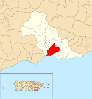
Location of Pollos within the municipality of Patillas shown in red
|
|
| Commonwealth | |
| Municipality | |
| Area | |
| • Total | 3.84 sq mi (9.9 km2) |
| • Land | 3.26 sq mi (8.4 km2) |
| • Water | 0.58 sq mi (1.5 km2) |
| Elevation | 85 ft (26 m) |
| Population
(2010)
|
|
| • Total | 3,146 |
| • Density | 965/sq mi (373/km2) |
| Source: 2010 Census | |
| Time zone | UTC−4 (AST) |
Pollos is a community, also known as a barrio, located in the town of Patillas, Puerto Rico. It is found on the beautiful island of Puerto Rico. In 2010, about 3,146 people lived in Pollos.
Contents
History of Pollos
How Pollos Became Part of the U.S.
Puerto Rico used to be controlled by Spain. After the Spanish–American War in 1898, Spain gave Puerto Rico to the United States. This happened because of a special agreement called the Treaty of Paris of 1898.
Because of this treaty, Puerto Rico became an unincorporated territory of the United States. This means it is a place that belongs to the U.S. but is not a state.
Early Population Counts
In 1899, the United States government took a count of all the people in Puerto Rico. This was like a first census. They found that the communities of Ríos and Pollos together had 1,075 people.
The population of Pollos has changed over the years, as shown in the table below:
| Historical population | |||
|---|---|---|---|
| Census | Pop. | %± | |
| 1910 | 767 | — | |
| 1920 | 998 | 30.1% | |
| 1930 | 776 | −22.2% | |
| 1940 | 1,318 | 69.8% | |
| 1950 | 1,437 | 9.0% | |
| 1980 | 2,320 | — | |
| 1990 | 2,525 | 8.8% | |
| 2000 | 3,409 | 35.0% | |
| 2010 | 3,146 | −7.7% | |
| U.S. Decennial Census 1899 (shown as 1900) 1910-1930 1930-1950 1980-2000 2010 |
|||
Understanding Sectors in Pollos
What are Barrios and Sectors?
In Puerto Rico, a "barrio" is like a small district or neighborhood. These barrios are then divided into even smaller areas. These smaller areas are called sectores (which means sectors in English).
The types of sectors can be different. Some are simply called "sector," while others might be called "urbanización" (urbanization), "reparto" (development), "barriada" (slum or neighborhood), or "residencial" (residential area).
Main Sectors in Pollos Barrio
Here are some of the different sectors you can find within the Pollos barrio:
- Calle Acueducto
- Calle Alberto Ricci
- Calle Canario
- Calle Cerezos
- Calle Cristo
- Calle Culto
- Calle El Hoyo
- Calle Félix Portugués
- Calle Flamboyán
- Calle Francisco Ortiz Lebrón
- Calle Guillermo Riefkhol
- Calle Helechos
- Calle Iglesia
- Calle Jesús T. Piñero
- Calle Las Flores
- Calle Las Rosas
- Calle Luna
- Calle Margarita
- Calle Muñoz Rivera
- Calle Octavio Rivera
- Calle Recreo
- Calle Reymundo Fernández
- Calle Robles
- Calle Salsipuedes
- Calle Santiago Iglesias
- Calle Tamarindo
- Calle Yarino
- Carretera 3
- Carretera 757
- Carretera 7757
- Parcelas Nuevas
- Parcelas Viejas (Calles 1, 2, 3, 4)
- Sector Caguitas
- Sector La Ceiba
- Sector La Luna
- Sector La Plo
- Sector Mariani
- Sector Providencia
- Sector Pueblito Nuevo
- Sector Tres Puertas
- Urbanización Montecielo
- Urbanización Valle de la Providencia
See also
 In Spanish: Pollos (Patillas) para niños
- List of communities in Puerto Rico
- List of barrios and sectors of Patillas, Puerto Rico
 | Isaac Myers |
 | D. Hamilton Jackson |
 | A. Philip Randolph |


