Pomona, New York facts for kids
Quick facts for kids
Pomona, New York
|
|
|---|---|
| Incorporated Village of Pomona | |

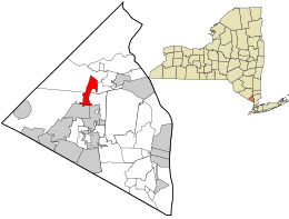
Location in Rockland County and the state of New York.
|
|
| Country | |
| State | |
| County | Rockland |
| Incorporated | February 3, 1967 |
| Area | |
| • Total | 2.40 sq mi (6.21 km2) |
| • Land | 2.40 sq mi (6.21 km2) |
| • Water | 0.00 sq mi (0.00 km2) |
| Elevation | 453 ft (138 m) |
| Population
(2020)
|
|
| • Total | 3,824 |
| • Density | 1,594.00/sq mi (615.56/km2) |
| Time zone | UTC-5 (Eastern (EST)) |
| • Summer (DST) | UTC-4 (EDT) |
| ZIP code |
10970
|
| Area code(s) | 845 |
| FIPS code | 36-58992 |
| GNIS feature ID | 0960875 |
Pomona is a small village in Rockland County, New York, United States. It is split between two towns: Ramapo and Haverstraw. Pomona is located near Harriman State Park.
In 2020, about 3,824 people lived in Pomona. This was a 23% increase from 2010.
Contents
History of Pomona Village
The village of Pomona was officially created on February 3, 1967. This means it became its own local government. The famous actor Burgess Meredith helped provide the money needed to start the village.
Pomona got its name from an old story. Pomona was the name of a goddess of fruit trees, gardens, and orchards. The area had many apple orchards, so the name fit perfectly.
Geography and Location
Pomona is located at coordinates 41.186504 degrees North and -74.055417 degrees West.
The village covers a total area of about 2.4 square miles (6.2 square kilometers). Most of this land is in the town of Haverstraw, and a smaller part is in the town of Ramapo. All of Pomona's area is land, with no large bodies of water.
Population and People
The number of people living in Pomona has grown over the years:
- 1970: 1,792 people
- 1980: 2,421 people
- 1990: 2,611 people
- 2000: 2,726 people
- 2010: 3,103 people
- 2020: 3,824 people
In 2010, there were 1,011 households in the village. Most households (75.6%) were married couples living together. About 32.7% of households had children under 18. The average household had about 3 people.
The median age in Pomona in 2010 was 45.5 years old. This means half the people were younger than 45.5, and half were older.
Historical Markers to See
Historical markers are special signs or plaques that tell you about important places or events.
- Ladentown United Methodist Church: This church is located at 14 Ladentown Road. It is listed on the National Register of Historic Places.
- The Pig Knoll School: You can find this old school at 584 Route 306. Today, it is used as the Pomona Cultural Center.
Landmarks and Places of Interest
There are several interesting places to visit in Pomona:
- Clover Stadium: This is a sports stadium that has had a few different names over the years.
- Pomona Cultural Center: Located at 584 Route 306, this center hosts various community events.
- Seaman-Knapp House: This historic house was built around 1799 and is known for its Greek Revival style.
Parks in Pomona
Pomona has a few parks where you can enjoy the outdoors:
- Burgess Meredith Park
- Secor Park
- Van den Hende Park
Sports Teams
- New York Boulders: This is a professional baseball team that plays in Pomona. They are part of the Frontier League.
Images for kids
See also
 In Spanish: Pomona (Nueva York) para niños


