Ponce de Leon, Florida facts for kids
Quick facts for kids
Ponce de Leon, Florida
|
|
|---|---|
| Town of Ponce de Leon | |

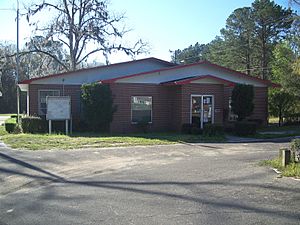
Ponce de Leon Town Hall
|
|
| Motto(s):
"Fountain of Youth for Family Fun"
|
|

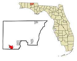
Location in Holmes County and the state of Florida
|
|
| Country | |
| State | |
| County | Holmes |
| Settled | c. 1830 |
| Incorporated | 1963 |
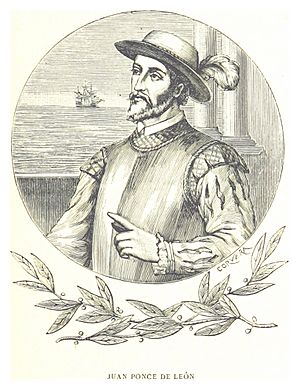
| Named for | Juan Ponce de León |
| Government | |
| • Type | Mayor-Council |
| Area | |
| • Total | 5.00 sq mi (12.95 km2) |
| • Land | 4.96 sq mi (12.85 km2) |
| • Water | 0.04 sq mi (0.10 km2) |
| Elevation | 62 ft (19 m) |
| Population
(2020)
|
|
| • Total | 504 |
| • Density | 101.59/sq mi (39.23/km2) |
| Time zone | UTC-6 (Central (CST)) |
| • Summer (DST) | UTC-5 (CDT) |
| ZIP code |
32455
|
| Area code(s) | 850 |
| FIPS code | 12-58175 |
| GNIS feature ID | 0289171 |
Ponce de Leon (pronounced PONSS-də-LEE-ən) is a small town in Holmes County, Florida, in the United States. This town is named after Juan Ponce de León, a famous Spanish explorer. It is located in the Florida Panhandle, which is the northwestern part of Florida.
In 2020, the town had a population of 504 people. This number was a bit lower than the 598 people who lived there in 2010.
Contents
Geography of Ponce de Leon

The town of Ponce de Leon is found in the southwestern part of Holmes County. Its exact location is around 30.725783 degrees North and 85.937783 degrees West.
Roads and Travel
U.S. Route 90 goes right through the middle of the town. If you travel northeast on this road, you will reach Bonifay, which is the main town of Holmes County, about 17 miles away. Going west for 11 miles on the same road takes you to DeFuniak Springs.
Florida State Road 81 crosses US 90 in the town center. This road goes north for 20 miles to the Alabama border. If you go south for 19 miles, you will reach Florida State Road 20 near Bruce.
Interstate 10 also passes through the southern part of Ponce de Leon. You can get on I-10 from Exit 96 (SR 81). This interstate highway leads east for 107 miles to Tallahassee. If you go west, it's 88 miles to Pensacola.
Area and Water Features
The town covers a total area of about 5 square miles (12.9 square kilometers). Most of this area, about 4.96 square miles (12.8 square kilometers), is land. A small part, about 0.04 square miles (0.1 square kilometers), is water.
Ponce de Leon is located in the valley of Sandy Creek. This creek flows south and is a branch of the Choctawhatchee River.
Ponce de Leon Springs State Park
Ponce de Leon Springs State Park is a special natural area located in the southern part of the town. It is north of Interstate 10 and sits on both sides of Sandy Creek. Visitors can enter the park from Ponce de Leon Springs Road on the eastern side.
Climate in Ponce de Leon
The weather in Ponce de Leon has hot and humid summers. The winters are usually mild, meaning they are not too cold. This type of weather is known as a humid subtropical climate.
Population and People
| Historical population | |||
|---|---|---|---|
| Census | Pop. | %± | |
| 1970 | 288 | — | |
| 1980 | 454 | 57.6% | |
| 1990 | 406 | −10.6% | |
| 2000 | 457 | 12.6% | |
| 2010 | 598 | 30.9% | |
| 2020 | 504 | −15.7% | |
| U.S. Decennial Census | |||
The population of Ponce de Leon has changed over the years. In 1970, there were 288 people. The population grew to 598 in 2010, but then decreased to 504 in 2020.
Understanding the Census
A census is like a big count of all the people living in a place. The U.S. government does a census every ten years to learn about the population. This helps them understand how communities are growing and changing.
Population Details from 2020
According to the 2020 census, there were 504 people living in Ponce de Leon. These people lived in 225 different homes, and 167 of these homes were families.
The table below shows the different groups of people living in Ponce de Leon, based on the 2010 and 2020 censuses. It helps us see how the town's population has changed over time.
| Race | Pop 2010 | Pop 2020 | % 2010 | % 2020 |
|---|---|---|---|---|
| White (NH) | 548 | 472 | 91.64% | 93.65% |
| Black or African American (NH) | 11 | 2 | 1.84% | 0.40% |
| Native American or Alaska Native (NH) | 6 | 3 | 1.00% | 0.60% |
| Asian (NH) | 2 | 2 | 0.33% | 0.40% |
| Pacific Islander or Native Hawaiian (NH) | 1 | 0 | 0.17% | 0.00% |
| Some other race (NH) | 0 | 0 | 0.00% | 0.00% |
| Two or more races/Multiracial (NH) | 12 | 12 | 2.01% | 2.38% |
| Hispanic or Latino (any race) | 18 | 13 | 3.01% | 2.58% |
| Total | 598 | 504 |
See also
 In Spanish: Ponce de León (Florida) para niños


