Portland (CDP), Connecticut facts for kids
Quick facts for kids
Portland, Connecticut
|
|
|---|---|

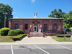
Post Office
|
|
| Country | |
| State | Connecticut |
| County | Middlesex |
| Town | Portland |
| Area | |
| • Total | 17.16 km2 (6.63 sq mi) |
| • Land | 15.53 km2 (6.00 sq mi) |
| • Water | 1.63 km2 (0.63 sq mi) |
| Elevation | 50 m (170 ft) |
| Population
(2020)
|
|
| • Total | 5,813 |
| • Density | 374.4/km2 (970/sq mi) |
| Time zone | UTC-5 (Eastern (EST)) |
| • Summer (DST) | UTC-4 (EDT) |
| ZIP Code |
06480
|
| Area code(s) | 860/959 |
| FIPS code | 09-61870 |
| GNIS feature ID | 2377853 |
Portland is a special kind of area in Connecticut, United States. It's called a census-designated place (CDP). This means it's a part of the larger town of Portland that the government counts separately for population.
Portland is located in Middlesex County. It sits in the southwest part of the town. The Connecticut River forms its western and southern borders. This river also separates Portland from the towns of Cromwell and Middletown.
About Portland, Connecticut
Portland is a charming place with a mix of homes and businesses. It includes the main village area and nearby neighborhoods. One of these neighborhoods is called Gildersleeve, located in the northern part of the CDP.
Where is Portland Located?
The area of Portland, CDP, stretches north along Main Street. This road is also known as Connecticut Route 17A. It goes up to where it meets Gospel Lane, which is Connecticut Route 17. The eastern edge of the CDP is around Rose Hill Road and Collins Hill Road.
Population of Portland
According to the 2020 census, about 5,813 people live in the Portland CDP. This is a part of the total population of the entire town of Portland, which was 9,384 people at that time.
 | William M. Jackson |
 | Juan E. Gilbert |
 | Neil deGrasse Tyson |


