
Poverty Point facts for kids
Quick facts for kids Poverty Point National Monument |
|
|---|---|
.png)
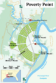
A map of the Poverty Point site
|
|

Poverty Point National Monument
Location in Louisiana

Poverty Point National Monument
Location in the United States
|
|
| Location | West Carroll Parish, Louisiana, U.S. |
| Nearest city | Epps, Louisiana |
| Area | 910.85 acres (368.61 ha) |
| Authorized | October 31, 1988 |
| Governing body | Louisiana Office of State Parks |
| Website | Poverty Point National Monument |
| Official name: Monumental Earthworks of Poverty Point | |
| Type: | Cultural |
| Criteria: | iii |
| Designated: | 2014 (38th session) |
| Reference #: | 1435 |
| Region: | Europe and North America |

Poverty Point is an amazing place in northeastern Louisiana. It has huge earthworks built by Native Americans long ago. These earthworks include large mounds and ridges made of dirt.
The people who built Poverty Point lived there between 1700 and 1100 BCE. That's about 3,700 to 3,100 years ago! They were part of a group called the Poverty Point culture. Their culture spread across a large area in the southeastern United States.
Today, Poverty Point is a special place. It is a state historic site and a U.S. National Monument. It is also a UNESCO World Heritage Site. This means it is important to the whole world, like the Egyptian Pyramids or Stonehenge.
Archaeologists are scientists who study old things. They have been digging and studying Poverty Point since the 1950s. They want to learn how and why these amazing earthworks were built.
Contents
What Poverty Point Looks Like
The main part of Poverty Point has huge earthworks. These include six C-shaped ridges, several mounds, and a big open area called a plaza. The entire site covers about 345 acres (140 hectares). That's like 260 football fields!
The Six C-Shaped Ridges
The most unique part of Poverty Point is its six C-shaped ridges. They are built one inside the other, like a giant target. Each ridge is separated by a small ditch.
These ridges are divided into sections by four pathways. They are not very tall today, only about 0.3 to 6 feet (10 to 185 cm) high. This is because farming over many years has worn them down.
The outermost ridge is about three-quarters of a mile (1.2 km) across. The innermost ridge is about three-eighths of a mile (0.6 km) across. These ridges are so big that people didn't realize their shape until they saw them from airplanes! Scientists believe most of them were built between 1600 and 1300 BCE.
The Plaza
Inside the innermost ridge is a large, flat area called the plaza. It's about 37.5 acres (17.4 hectares) in size. Even though it looks natural, the plaza was changed by the ancient builders. They filled in low spots and added dirt to make it level.
Archaeologists found signs of huge wooden posts in the plaza. These posts might have formed large circles. They were built around the same time as the earthworks.
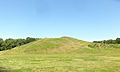
Mound A


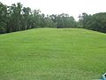
The mounds are the easiest earthworks to see. The biggest one is Mound A. It is 72 feet (22 meters) tall, which is like a seven-story building! Its base is about 705 by 660 feet (215 by 200 meters).
Mound A is shaped like a T when seen from above. Some people think it looks like a bird. It was built very quickly, maybe in less than three months! Before building, the area was burned, and then dirt was piled on top.
This mound is made of about 8.4 million cubic feet (238,000 cubic meters) of dirt. This makes it the second-largest earthen mound in eastern North America. The dirt was likely carried from nearby pits.
Mound B

Mound B is north of the ridges. It is shaped like a cone, about 21 feet (6.5 meters) tall. It was one of the first earthworks built at Poverty Point, sometime after 1700 BCE.
Mound B was built in several steps. Archaeologists found charcoal and fire pits inside it. They even found impressions of woven baskets in the dirt, showing how the dirt was carried.
Mound C
Mound C is inside the plaza. It is 6.5 feet (2 meters) tall and about 260 feet (80 meters) long. It was built over time with many thin layers of different soils. This shows it was added to bit by bit.
Mound D
Mound D is a rectangular mound with a flat top. It is about 4 feet (1.2 meters) tall. This mound might have been built by a different group of people, the Coles Creek culture. They lived nearly 2,000 years after the Poverty Point people.
Mound E
Mound E is sometimes called the Ballcourt Mound. It is a rectangular mound with rounded corners and a ramp. It is 13.4 feet (4 meters) tall. This mound was also built in several stages.
Mound F
A sixth mound, Mound F, was found in 2013. It is about 5 feet (1.5 meters) tall. It was built around 1280 BCE, making it one of the last mounds added to the site by the Poverty Point people.
Nearby Mounds
There are two other important mounds nearby. The Lower Jackson Mound is south of Poverty Point. It is older, built around 3900 to 3600 BCE, long before Poverty Point. The Motley Mound is north of Poverty Point. Its builders are still a mystery.
How Poverty Point Was Built

Poverty Point was not built all at once. It was created over many years by different generations of people. Building started as early as 1800 BCE and continued until about 1200 BCE.
Before building, the ancient workers leveled the land. They filled in low areas to create flat surfaces for the mounds and ridges. They mostly used a type of soil called loess, which is easy to dig.
The earthworks were built by dumping basket loads of dirt. Each basket could hold about 30 to 50 pounds (14 to 23 kg) of dirt. This suggests that men, women, and children all helped with the building!
Scientists believe that if 100 people worked on the project for six or seven days a month, it would have taken about 100 years to build the earthworks. This means many generations contributed to this huge project.
Why Poverty Point Was Built

Archaeologists have different ideas about why Poverty Point was built.
Some think it was a large settlement where people lived all the time. They found signs of houses and cooking areas on the ridges.
Others believe it was a place where different groups met for special events or to trade goods. However, some archaeologists think there's too much evidence of daily life for it to be only an occasional meeting place.
Some also believe Poverty Point had religious meaning. The pathways dividing the ridges might have lined up with the sun's movements. This could mean the site was used for ceremonies related to the sun or stars.
The Poverty Point People

The people who built Poverty Point were hunter-gatherers. This means they got their food by hunting animals, fishing, and gathering plants. They did not farm like most other groups who built large monuments. This makes them very special!
They were Native Americans, whose ancestors came to North America thousands of years ago. We don't know which modern tribes are directly related to the Poverty Point people.
Their diet included deer, possums, fish, turtles, nuts, fruits, and berries. They ate different foods depending on the season.
Artifacts

Many small, baked clay objects have been found at Poverty Point. They are called "Poverty Point Objects" or PPOs. These objects were likely used for cooking in earth ovens. They would hold heat and help cook food.
The Poverty Point people made some pottery, but they also traded for stone bowls made of steatite from distant mountains.
They made many tools on site. Different areas of the earthworks were used for different activities. For example, the north part was good for making tools, while the south part was where tools like spear points were used.
The Poverty Point people traded a lot! They got stone from places like the Ouachita Mountains, Ozark Mountains, and even the Ohio River and Tennessee River valleys. They also traded for soapstone from Alabama and Georgia, and galena (a type of lead ore) from Missouri and Iowa. This shows they had connections with people far away.
Discovery and Protection

People in the 1800s started writing about Poverty Point. One explorer, Jacob Walter, found it in the 1830s while looking for lead. He described the huge mound (Mound A) and many clay objects.
Archaeologists became very interested in the site in the early 1900s. Many scientists have studied and dug at Poverty Point over the years. Their work helps us understand this ancient place.
In 1960, a park service archaeologist suggested Poverty Point become a national monument. In 1972, the state of Louisiana bought part of the site. They opened it to the public in 1976 as a state park. A museum was built to show the earthworks and artifacts.
In 1988, the U.S. government officially made Poverty Point a National Monument. Today, you can visit Poverty Point National Monument almost every day.
World Heritage Site
In 2013, the United States asked UNESCO to add Poverty Point to its World Heritage List. This list includes the most important cultural and natural sites in the world.
On June 22, 2014, UNESCO officially named Poverty Point a World Heritage Site! This was a huge honor. It was the first World Heritage Site in Louisiana and the 22nd in the United States. This shows how important Poverty Point is to understanding human history.
Images for kids
-
A map of the Poverty Point site
-
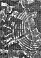
Poverty Point from above in 1938
-
Mound A at Poverty Point
-
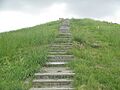
Steps (since removed) to top of Mound A
-
Mound B field
-
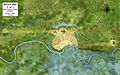
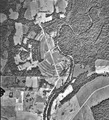
An overview of the Poverty Point site showing the locations of the nearby Motley and Lower Jackson mounds. North is to the right.
-
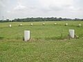
Barrels outline circular structures in the plaza
-
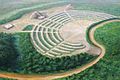
An artist's idea of what Poverty Point looked like when finished.
-
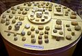
Baked clay objects found at Poverty Point
-
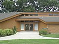
Museum at Poverty Point
-
An aerial view of the earthworks at Poverty Point in 1960.

See also
 In Spanish: Poverty Point para niños
