
Province of Fermo facts for kids
Quick facts for kids
Province of Fermo
Provincia di Fermo
|
||
|---|---|---|

The Palazzo dei Prori in Fermo
|
||
|
||

Map with the province of Fermo, in red, in Italy
|
||
| Country | ||
| Region | Marche | |
| Capital | Fermo | |
| Comuni | 40 | |
| Area | ||
| • Total | 862.77 km2 (333.12 sq mi) | |
| Population
(1 January 2017)
|
||
| • Total | 174,849 | |
| • Density | 202.6600/km2 (524.887/sq mi) | |
| Time zone | UTC+1 (CETU) | |
| • Summer (DST) | UTC+2 (CEST) | |
| Postal code |
63900
|
|
| Telephone prefix | 0734, 0736 | |
| Vehicle registration | FM | |
| ISTAT | 109 | |
| Website | Official website: http://www.provincia.fermo.it/ | |

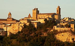
The Province of Fermo (Italian: Provincia di Fermo) is a special area in the Marche region of Italy. Its main city, or capital, is Fermo.
It became a province in 2004, taking parts from the province of Ascoli Piceno. But it wasn't until 2009 that it fully started working as its own province.
Contents
Where is Fermo Province?

The Province of Fermo is about 862.77 square kilometers big. It's the smallest province in the Marche region.
It's surrounded by other provinces. To the north and west is the province of Macerata. To the south is the province of Ascoli Piceno. To the east, it touches the beautiful Adriatic Sea.
 |
Province of Macerata | Adriatic Sea | |
|
| Province of Macerata | Adriatic Sea | |||
| Province of Ascoli Piceno |
Rivers and Mountains
Several rivers flow through the province. Most of them flow east into the Adriatic Sea.
- Chienti - This river is 91 km long. It flows into the sea near Civitanova Marche.
- Tenna - This river is 70 km long. Its mouth is near Porto Sant'Elpidio.
- Ete Morto - This river is 40 km long. It's a tributary (a smaller river that flows into a larger one) of the Chienti river.
- Ete Vivo - This river is 35 km long. It flows into the sea near Porto San Giorgio.
- Aso - This river is 63 km long. Its mouth is near Pedaso.
The highest mountain in the province is Monte Priora. It's part of the Apennines mountain range. Monte Priora is 2,332 meters high.
How Many People Live Here?
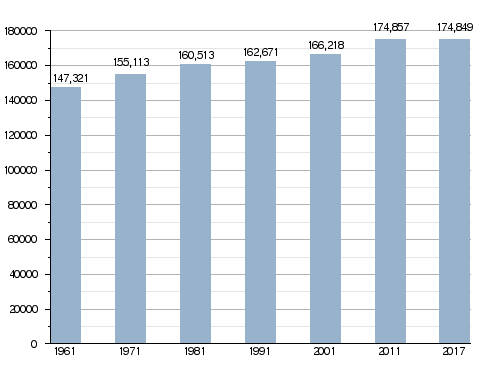
About 174,849 people lived in the province on January 1, 2017. This means there were about 203 people living in each square kilometer.
Population Changes Over Time
Towns and Villages
There are 40 towns and villages, called comuni, in the Province of Fermo.
- Altidona
- Amandola
- Belmonte Piceno
- Campofilone
- Falerone
- Fermo
- Francavilla d'Ete
- Grottazzolina
- Lapedona
- Magliano di Tenna
- Massa Fermana
- Monsampietro Morico
- Montappone
- Monte Giberto
- Monte Rinaldo
- Monte San Pietrangeli
- Monte Urano
- Monte Vidon Combatte
- Monte Vidon Corrado
- Montefalcone Appennino
- Montefortino
- Montegiorgio
- Montegranaro
- Monteleone di Fermo
- Montelparo
- Monterubbiano
- Montottone
- Moresco
- Ortezzano
- Pedaso
- Petritoli
- Ponzano di Fermo
- Porto San Giorgio
- Porto Sant'Elpidio
- Rapagnano
- Sant'Elpidio a Mare
- Santa Vittoria in Matenano
- Servigliano
- Smerillo
- Torre San Patrizio
The largest comune by area is Fermo, covering 124.53 square kilometers. The smallest is Pedaso, which is only 3.85 square kilometers. The comune with the fewest people is Smerillo, with just 366 residents.
Biggest Towns
Here are the 10 comuni with the most people living in them:
| No. | Comune | Population (2017) |
Area (km²) |
Density | Altitude (m) |
|---|---|---|---|---|---|
| 1 | Fermo | 37,396 | 124.53 | 300.3 | 319 |
| 2 | Porto Sant'Elpidio | 26,270 | 18.13 | 1,449.0 | 4 |
| 3 | Sant'Elpidio a Mare | 17,073 | 50.52 | 337.9 | 251 |
| 4 | Porto San Giorgio | 16,066 | 8.79 | 1,827.8 | 4 |
| 5 | Montegranaro | 12,925 | 31.42 | 411.4 | 279 |
| 6 | Monte Urano | 8,280 | 16.72 | 495.2 | 247 |
| 7 | Montegiorgio | 6,789 | 47.45 | 143.1 | 411 |
| 8 | Amandola | 3,624 | 69.50 | 52.1 | 500 |
| 9 | Altidona | 3,411 | 12.97 | 263.0 | 224 |
| 10 | Grottazzolina | 3,382 | 9.26 | 365.2 | 227 |
Gallery
-
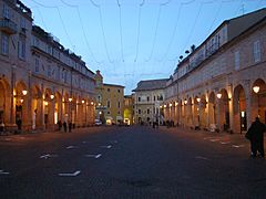
Piazza del Popolo, a main square in Fermo.
-
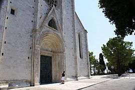
The beautiful Cathedral of Fermo.
-
Villa Castellano in Porto Sant'Elpidio.
-
The historic center of Sant'Elpidio a Mare.


Related pages
See also
 In Spanish: Provincia de Fermo para niños
