
Province of Macerata facts for kids
Quick facts for kids
Province of Macerata
|
|
|---|---|

Palazzo degli Studi in Macerata, the provincial seat.
|
|

Map with the province of Macerata, in red, in Italy
|
|
| Country | |
| Region | Marche |
| Capital | Macerata |
| Comuni | 55 |
| Area | |
| • Total | 2,779.34 km2 (1,073.11 sq mi) |
| Population
(January 2017)
|
|
| • Total | 318,921 |
| • Density | 114.7470/km2 (297.1934/sq mi) |
| Time zone | UTC+1 (CETU) |
| • Summer (DST) | UTC+2 (CEST) |
| Postal code |
62100
|
| Telephone prefix | 0733 |
| Vehicle registration | MC |
| ISTAT | 043 |
| Website | Official website: http://www.provincia.mc.it/ |
The Province of Macerata (which in Italian is Provincia di Macerata) is a special area in the Marche region of Italy. It is like a large county. The main city and capital of this province is Macerata.
Contents
Exploring Macerata Province

The Province of Macerata is the largest province in the Marche region. It covers an area of about 2,779 square kilometers (1,073 square miles).
To the east, the province touches the Adriatic Sea. To the west, it borders the Umbria region, specifically the Province of Perugia. Macerata is also special because it borders three other provinces within its own Marche region. These are Ancona to the north, Ascoli Piceno to the southwest, and Fermo to the south.
Two important rivers flow through the province. The Chienti River is about 91 kilometers (57 miles) long. The Potenza River is a bit longer, at about 95 kilometers (59 miles).
People of Macerata Province
As of January 2017, about 318,921 people live in the Province of Macerata. This means there are about 115 people living in each square kilometer.
The number of people living in the province has changed over the years. You can see how the population has grown and shrunk in the chart below.

Towns and Villages
The Province of Macerata has 55 towns and villages. In Italy, these are called comuni.
- Apiro
- Appignano
- Belforte del Chienti
- Bolognola
- Caldarola
- Camerino
- Camporotondo di Fiastrone
- Castelraimondo
- Castelsantangelo sul Nera
- Cessapalombo
- Cingoli
- Civitanova Marche
- Colmurano
- Corridonia
- Esanatoglia
- Fiastra
- Fiuminata
- Gagliole
- Gualdo
- Loro Piceno
- Macerata
- Matelica
- Mogliano
- Monte Cavallo
- Monte San Giusto
- Monte San Martino
- Montecassiano
- Montecosaro
- Montefano
- Montelupone
- Morrovalle
- Muccia
- Penna San Giovanni
- Petriolo
- Pieve Torina
- Pioraco
- Poggio San Vicino
- Pollenza
- Porto Recanati
- Potenza Picena
- Recanati
- Ripe San Ginesio
- San Ginesio
- San Severino Marche
- Sant'Angelo in Pontano
- Sarnano
- Sefro
- Serrapetrona
- Serravalle di Chienti
- Tolentino
- Treia
- Urbisaglia
- Ussita
- Valfornace
- Visso
The largest comune by area is San Severino Marche. It covers about 194 square kilometers (75 square miles). The smallest is Camporotondo di Fiastrone, with only about 8.8 square kilometers (3.4 square miles).
The comuni with the fewest people are Monte Cavallo, with 133 residents, and Bolognola, with 137 residents.
Biggest Towns
Here are the 10 comuni with the most people living in them. The table also shows their size and how high they are above sea level.
| No. | Comune | Population (2017) |
Area (km²) |
Density | Altitude (m) |
|---|---|---|---|---|---|
| 1 | Civitanova Marche | 42,251 | 46.07 | 917.1 | 3 |
| 2 | Macerata | 42,209 | 92.53 | 456.2 | 315 |
| 3 | Recanati | 21,241 | 103.46 | 205.3 | 293 |
| 4 | Tolentino | 19,831 | 95.12 | 208.5 | 228 |
| 5 | Potenza Picena | 15,836 | 48.55 | 326.2 | 237 |
| 6 | Corridonia | 15,461 | 61.97 | 249.5 | 255 |
| 7 | San Severino Marche | 12,630 | 194.26 | 65.0 | 235 |
| 8 | Porto Recanati | 12,571 | 17.25 | 728.8 | 6 |
| 9 | Cingoli | 10,289 | 148.20 | 69.4 | 631 |
| 10 | Morrovalle | 10,150 | 42.58 | 238.4 | 245 |
Images for kids
-
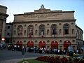
Sferisterio, a famous arena in Macerata.
-
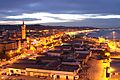
Civitanova Marche at sunrise.
-
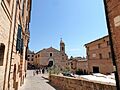
The main square in Recanati with Palazzo Leopardi.
-
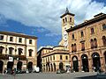
Piazza della Libertà (Liberty Square) in Tolentino.
-
The Castle of Monte Nero in San Severino Marche.


Related pages
See also
 In Spanish: Provincia de Macerata para niños
