
Province of Perugia facts for kids
Quick facts for kids
Province of Perugia
|
|
|---|---|

Palazzo della Provincia, Perugia
|
|

Map with the province of Perugia, in red, in Italy
|
|
| Country | |
| Region | Umbria |
| Capital | Perugia |
| Comuni | 59 |
| Area | |
| • Total | 6,337.15 km2 (2,446.79 sq mi) |
| Population
(31 December 2015)
|
|
| • Total | 662,110 |
| • Density | 104.4807/km2 (270.6038/sq mi) |
| Time zone | UTC+1 (CET) |
| • Summer (DST) | UTC+2 (CEST) |
| Postal code |
06010-06089, 06100
|
| Telephone prefix | 075, 0578, 0742, 0743 |
| Vehicle registration | PG |
| ISTAT | 054 |
| Website | Official website: http://www.provincia.perugia.it/ |
The Province of Perugia (called provincia di Perugia in Italian) is an important area in the Umbria region of Central Italy. Its main city and capital is Perugia. Did you know that the city of Perugia is also the capital of the entire Umbria region?
Contents
A Look Back: History of Perugia Province
The Province of Perugia was first created in 1860. Back then, it was known as the Province of the Umbria. It was much bigger than it is today!
At that time, the area that is now the Province of Terni was part of the Province of Perugia. But things changed in 1927. The large old province was split into two smaller provinces: Perugia and Terni.
Exploring the Land: Geography of Perugia
The Province of Perugia is the larger of the two provinces in Umbria. It covers an area of about 6,337 square kilometers (2,447 square miles). That's a lot of land to explore!
The province shares its borders with several other regions and provinces. To the north and east, it meets the Marche region. This includes the provinces of Pesaro and Urbino, Ancona, Macerata, and Ascoli Piceno.
To the south, Perugia borders Lazio (specifically the province of Rieti) and its sister province, province of Terni. To the west, it touches Tuscany, including the provinces of Siena and Arezzo.
 |
Marche | |
||
| Tuscany | Marche | |||
| Terni province, Lazio |
Water Wonders: Rivers and Lakes
The most important river flowing through this region is the Tiber. It's a very famous river in Italy!
The biggest lake in the province, and in all of Umbria, is Trasimeno. It's one of the largest lakes in Italy, perfect for boating or just enjoying the view.
High Peaks and Green Spaces: Mountains and Parks
The highest mountain in the province is Cima del Redentore. It's part of the same mountain group as Monte Vettore. This peak reaches an impressive height of 2,448 meters (8,031 feet)!
Perugia is also home to beautiful natural parks. There are four regional parks: Parco di Colfiorito, Parco del Lago Trasimeno, Parco del Monte Cucco, and Parco del Monte Subasio. A part of the Monti Sibillini National Park (called Parco Nazionale dei Monti Sibillini in Italian) is also found here, though most of it is in the Marche region.
People of Perugia: Population Facts
As of December 31, 2015, about 662,110 people lived in the Province of Perugia. This means there were about 104.5 people living in each square kilometer (270 people per square mile). It's a busy place!
How Perugia Province is Run: Administration

The province is divided into 59 smaller areas called comuni. Think of comuni as towns or municipalities, each with its own local government.
Main Cities and Towns: The Comuni
Here are some of the comuni with the most people living in them:
| Comune | Population | Area (km²) |
|---|---|---|
| Perugia | 166,134 | 449.51 |
| Foligno | 57,155 | 264.67 |
| Città di Castello | 39,913 | 387.32 |
| Spoleto | 38,218 | 348.14 |
| Gubbio | 32,216 | 525.78 |
| Assisi | 28,299 | 187,19 |
| Bastia Umbra | 21,874 | 27,60 |
| Corciano | 21,332 | 63,72 |
The largest comune by land area is Gubbio, covering about 525.78 square kilometers (203 square miles). The smallest is Paciano, with only about 16.91 square kilometers (6.53 square miles). The comune with the fewest people is Poggiodomo, with just 117 inhabitants.
A Visual Journey: Gallery


Images for kids
-
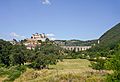
Spoleto

Want to Learn More?
 In Spanish: Provincia de Perugia para niños
