
Province of Rieti facts for kids
Quick facts for kids
Province of Rieti
|
|
|---|---|

Palazzo d'Oltre Velino, Rieti.
|
|

Map with the province of Rieti, in red, in Italy
|
|
| Country | |
| Region | Lazio |
| Capital | Rieti |
| Comuni | 73 |
| Area | |
| • Total | 2,750.52 km2 (1,061.98 sq mi) |
| Population
(January 2017)
|
|
| • Total | 157,429 |
| • Density | 57.23609/km2 (148.2408/sq mi) |
| Time zone | UTC+1 (CET) |
| • Summer (DST) | UTC+2 (CEST) |
| Postal code |
02100 Rieti, 02010-02048
|
| Telephone prefix | 0744, 0746, 0765 |
| Vehicle registration | RI |
| ISTAT | 057 |
| Website | Official website: http://www.provincia.rieti.it/ |
The Province of Rieti is a special area in the Lazio region of Central Italy. It's like a county, and its main city, or capital, is Rieti. In Italian, it's called Italian: Provincia di Rieti.
Contents
History of Rieti Province
The Province of Rieti was formed in January 1927. It was created using parts of two other provinces: Rome and L'Aquila.
Geography of Rieti
.svg)
The Province of Rieti covers an area of about 2,750 square kilometers (1,062 square miles). It is the second smallest province in the Lazio region.
Location and Borders
This province is located in the northeast part of the Lazio region. It shares borders with several other areas:
- To the west, along the Tiber river, it borders the Viterbo province and the Rome province.
- To the north, it borders the Umbria region, which includes the provinces of Perugia and Terni.
- To the east, it borders the Ascoli Piceno province in the Marche region. It also borders the provinces of L'Aquila and Teramo in the Abruzzo region.
 |
Viterbo province | Umbria | Ascoli Piceno province (Marche) and Teramo province (Abruzzo) |
|
| Rome | L'Aquila province | |||
| Rome | Rome | L'Aquila province |
Mountains in Rieti
The territory of the province is mostly mountainous. You can find several mountain ranges here:
- The Monti Sabini and Monti Reatini are in the north, near the border with the Umbria region.
- The Monti Terminillo and the Monti della Laga are located to the east.
- The Monti del Cicolano and Monti della Duchessa are in the southeast.
The highest mountain in the province is Monte Gorzano. It is part of the Monti della Laga range in the eastern part of the province. Monte Gorzano is about 2,458 meters (8,064 feet) tall. It sits along the border with the Teramo province.
Rivers and Lakes
The main rivers flowing through the province are:
- The Tiber river.
- The Velino river, which is 90 kilometers (56 miles) long. It flows into the Nera river.
- The Salto river, which is 55 kilometers (34 miles) long. It flows into the Velino river.
- The Turano river, which is 70 kilometers (43 miles) long. It also flows into the Velino river.
- The Corno river, which is 56 kilometers (35 miles) long. It flows into the Nera river.
There are also several artificial lakes in the province. The largest one is the Lago del Salto, which covers an area of about 10 square kilometers (3.9 square miles).
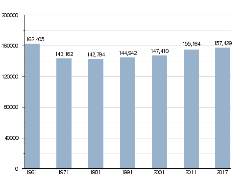
Population of Rieti Province
As of January 1, 2017, there were 157,429 people living in the Province of Rieti. This means there were about 57 people living in each square kilometer (148 people per square mile).
How the population of Rieti province has changed over time
Administration and Towns
The Province of Rieti is divided into 73 smaller areas called municipalities or comuni. Each comune is like a town or a small city with its own local government.
Here is a list of all the comuni in the province:
- Accumoli
- Amatrice
- Antrodoco
- Ascrea
- Belmonte in Sabina
- Borbona
- Borgo Velino
- Borgorose
- Cantalice
- Cantalupo in Sabina
- Casaprota
- Casperia
- Castel di Tora
- Castel Sant'Angelo
- Castelnuovo di Farfa
- Cittaducale
- Cittareale
- Collalto Sabino
- Colle di Tora
- Collegiove
- Collevecchio
- Colli sul Velino
- Concerviano
- Configni
- Contigliano
- Cottanello
- Fara in Sabina
- Fiamignano
- Forano
- Frasso Sabino
- Greccio
- Labro
- Leonessa
- Longone Sabino
- Magliano Sabina
- Marcetelli
- Micigliano
- Mompeo
- Montasola
- Monte San Giovanni in Sabina
- Montebuono
- Monteleone Sabino
- Montenero Sabina
- Montopoli di Sabina
- Morro Reatino
- Nespolo
- Orvinio
- Paganico Sabino
- Pescorocchiano
- Petrella Salto
- Poggio Bustone
- Poggio Catino
- Poggio Mirteto
- Poggio Moiano
- Poggio Nativo
- Poggio San Lorenzo
- Posta
- Pozzaglia Sabina
- Rieti
- Rivodutri
- Rocca Sinibalda
- Roccantica
- Salisano
- Scandriglia
- Selci
- Stimigliano
- Tarano
- Toffia
- Torri in Sabina
- Torricella in Sabina
- Turania
- Vacone
- Varco Sabino
The largest comune by area is Rieti, covering about 206.46 square kilometers (79.71 square miles). The smallest is Frasso Sabino, with an area of only about 4.39 square kilometers (1.69 square miles). The comune with the fewest people is Marcetelli, which has only 89 residents.
Largest Towns in Rieti Province
Here are the 10 comuni with the most people living in them, based on 2017 data. The table also shows their size and how high they are above sea level.
| No. | Comune | Population (2017) |
Area (km²) |
Density | Altitude (m) |
|---|---|---|---|---|---|
| 1 | Rieti | 47,552 | 206.46 | 230.3 | 405 |
| 2 | Fara in Sabina | 13,819 | 54.96 | 251.4 | 482 |
| 3 | Cittaducale | 6,786 | 71.25 | 95.2 | 481 |
| 4 | Poggio Mirteto | 6,343 | 26.40 | 240.3 | 246 |
| 5 | Borgorose | 4,542 | 145.82 | 31.1 | 732 |
| 6 | Montopoli di Sabina | 4,128 | 37.94 | 108.8 | 331 |
| 7 | Contigliano | 3,806 | 53.55 | 71.1 | 488 |
| 8 | Magliano Sabina | 3,740 | 43.23 | 86.5 | 222 |
| 9 | Forano | 3,160 | 17.69 | 178.6 | 218 |
| 10 | Scandriglia | 3,128 | 63.35 | 49.4 | 535 |
Gallery
-
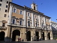
Palazzo Comunale, Rieti.
-
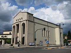
Saint Michael Archangel church in Rieti.
-
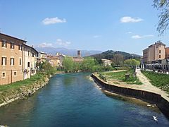
The Velino river in Rieti.
-
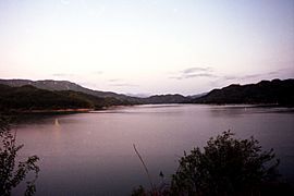
The Lago del Salto lake from the dam.


_esterno_01.jpg)


Related pages
See also
 In Spanish: Provincia de Rieti para niños
