
Province of Terni facts for kids
Quick facts for kids
Province of Terni
|
||
|---|---|---|

Palazzo Bazzani in Terni, the provincial seat
|
||
|
||

Map with the province of Terni, in red, in Italy
|
||
| Country | ||
| Region | Umbria | |
| Capital | Terni | |
| Comuni | 33 | |
| Area | ||
| • Total | 2,127.18 km2 (821.31 sq mi) | |
| Population
(31 December 2015)
|
||
| • Total | 229,071 | |
| • Density | 107.6876/km2 (278.9097/sq mi) | |
| Time zone | UTC+1 (CET) | |
| • Summer (DST) | UTC+2 (CEST) | |
| Postal code |
05010-05018, 05020-05026,
05028-05032, 05034-05035, 05039, 05100 |
|
| Telephone prefix | 075, 0744, 0763 | |
| Vehicle registration | TR | |
| ISTAT | 055 | |
| Website | Official website: http://www.provincia.terni.it/ | |

The Province of Terni is a special area in the Umbria region of Central Italy. It is like a large county or district. Its main city, and where its government is located, is Terni.
Contents
A Look at Terni's History
The Province of Terni was created in 1927. Before that, it was part of a bigger area called the Province of the Umbria. This older province was formed in 1860. In 1927, it was split into two new provinces: Perugia and Terni.
Exploring Terni's Geography
The Province of Terni covers about 2,127 square kilometers (821 square miles). This means it makes up about one-third of the total area of the Umbria region. It also has about one-third of Umbria's population.
Where is Terni Located?
The province is in the southwest part of the Umbria region. It shares borders with several other provinces. To the north, it borders the province of Perugia. To the east, south, and west, it borders parts of the Lazio region, specifically the Rieti and Viterbo provinces. To the northwest, it borders the Tuscany region, specifically the province of Siena.
 |
Tuscany | Perugia (province) | |
|
| Lazio | Lazio | |||
| Lazio |
Rivers and Mountains in Terni
The province is home to important river valleys. The Nera river flows through the area, joining with the Velino river. The eastern part of the Tiber river valley is also found here.
The highest point in the province is Monte Aspra. This mountain is located in the eastern part of the province. It stands tall at about 1,652 meters (5,420 feet) above sea level.
Nature Parks and Rivers
To protect its beautiful rivers and the areas around them, the Province of Terni has two special parks. These are called Parco fluviale del Tevere (which means "Fluvial park of the Tiber") and Parco fluviale del Nera (meaning "Fluvial park of the Nera"). These parks help keep the natural environment safe.
Population of Terni Province
As of December 31, 2015, about 229,071 people lived in the Province of Terni. This means that for every square kilometer, there were about 107 people. This number tells us how crowded or spread out the population is.
How Terni Province is Governed

The Province of Terni is made up of 33 smaller areas called comuni. These are like towns or local districts. Only four of these comuni have more than 10,000 people living in them. These larger comuni are:
| Comune | Population | Area (km²) |
|---|---|---|
| Terni | 111,501 | 212.43 |
| Orvieto | 20,630 | 281.27 |
| Narni | 19,785 | 197.99 |
| Amelia | 11,897 | 132.50 |
The largest comune by land area is Orvieto, covering about 281 square kilometers. The smallest comuni are Attigliano, Montefranco, and Penna in Teverina, each around 10 square kilometers. There are also two comuni with very few people: Parrano with 534 residents and Polino with only 233 residents.
Related pages
Images for kids
-
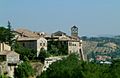
San Gemini
-
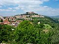
Amelia
-
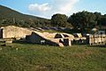
Ancient theater of Carsulae
-
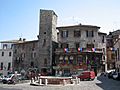
Central Square in Narni


See also
 In Spanish: Provincia de Terni para niños
