
Province of Ascoli Piceno facts for kids
Quick facts for kids
Province of Ascoli Piceno
|
|
|---|---|

Palazzo del Governo in Ascoli Piceno, the provincial seat.
|
|

Map highlighting, in red, the province of Ascoli Piceno in Italy
|
|
| Country | Italy |
| Region | Marche |
| Capital | Ascoli Piceno |
| Comuni | 33 |
| Area | |
| • Total | 1,228.27 km2 (474.24 sq mi) |
| Population | |
| • Total | 209,450 |
| • Density | 170.524/km2 (441.656/sq mi) |
| Time zone | UTC+1 (CET) |
| • Summer (DST) | UTC+2 (CEST) |
| Postal code |
63100
|
| Telephone prefix | 0736 |
| Vehicle registration | MC |
| ISTAT | 044 |
| Website | Official website: http://www.provincia.ap.it/ |
The Province of Ascoli Piceno (which in Italian is Provincia di Ascoli Piceno) is a special area in the Marche region of Italy. It's like a county or district. The main city and capital of this province is Ascoli Piceno.
Contents
Geography of Ascoli Piceno

The Province of Ascoli Piceno covers an area of about 1,228 square kilometers (474 square miles). To the east, it touches the Adriatic Sea. To the north, it shares borders with two other provinces: Macerata and Fermo.
This province also borders three different regions of Italy. To the south, it meets the Abruzzo region. To the southwest, you'll find the Lazio region. And to the west, it borders the Umbria region.
Rivers and Mountains
The most important river in the province is the Tronto River. It flows for about 115 kilometers (71 miles). The highest point in the province is Monte Vettore. This mountain reaches an altitude of 2,476 meters (8,123 feet) above sea level.
Population in Ascoli Piceno
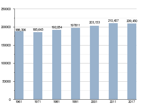
As of January 1, 2017, there were 209,450 people living in the Province of Ascoli Piceno. This means that for every square kilometer, there were about 170 people. This number is called the population density.
Population Changes Over Time
The number of people living in the province has changed over the years. The chart below shows how the population has grown or shrunk since 1961.
Municipalities of Ascoli Piceno
The Province of Ascoli Piceno is made up of 33 smaller towns or areas called comuni (municipalities). Each comune has its own local government.
Here is a list of all the comuni in the province:
- Acquasanta Terme
- Acquaviva Picena
- Appignano del Tronto
- Arquata del Tronto
- Ascoli Piceno
- Carassai
- Castel di Lama
- Castignano
- Castorano
- Colli del Tronto
- Comunanza
- Cossignano
- Cupra Marittima
- Folignano
- Force
- Grottammare
- Maltignano
- Massignano
- Monsampolo del Tronto
- Montalto delle Marche
- Montedinove
- Montefiore dell'Aso
- Montegallo
- Montemonaco
- Monteprandone
- Offida
- Palmiano
- Ripatransone
- Roccafluvione
- Rotella
- San Benedetto del Tronto
- Spinetoli
- Venarotta
The largest comune by land area is Ascoli Piceno, covering about 158 square kilometers (61 square miles). The smallest is Colli del Tronto, which is only about 5.94 square kilometers (2.29 square miles). The comune with the fewest people living in it is Palmiano, with only 188 residents.
Largest Comuni by Population
The table below shows the ten comuni with the most people living in them. It also includes their size and how high they are above sea level.
| No. | Comune | Population (2017) |
Area (km²) |
Density | Altitude (m) |
|---|---|---|---|---|---|
| 1 | Ascoli Piceno | 49,203 | 158.02 | 311.4 | 154 |
| 2 | San Benedetto del Tronto | 47,420 | 18.00 | 2,634.4 | 4 |
| 3 | Grottammare | 16,139 | 158.02 | 102.1 | 4 |
| 4 | Monteprandone | 12,602 | 26.38 | 477.7 | 273 |
| 5 | Folignano | 9,261 | 14.86 | 623.2 | 319 |
| 6 | Castel di Lama | 8,613 | 10.98 | 784.4 | 201 |
| 7 | Spinetoli | 7,221 | 12.58 | 574.0 | 177 |
| 8 | Cupra Marittima | 5,391 | 17.34 | 310.9 | 4 |
| 9 | Offida | 5,008 | 49.60 | 101.0 | 293 |
| 10 | Monsampolo del Tronto | 4,515 | 15.43 | 292.6 | 158 |
Images for kids
-
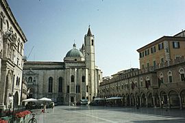
Piazza del Popolo, Ascoli Piceno.
-
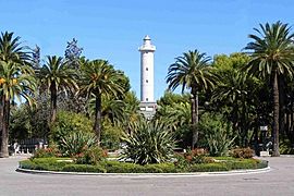
San Benedetto del Tronto.
-
Grottammare.
-
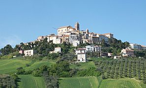
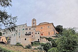
Monteprandone.


Related pages
See also
 In Spanish: Provincia de Ascoli Piceno para niños
