
Macerata facts for kids
Quick facts for kids
Macerata
|
||
|---|---|---|
| Comune di Macerata | ||
 |
||
|
||
.svg)
Location of Macerata within its province
|
||
| Country | Italy | |
| Region | Marche | |
| Province | Macerata (MC) | |
| Frazioni | Cimarella, Sforzacosta, Santa Maria del Monte, Piediripa, Villa Potenza, Madonna del Monte, Montanello, Montevinci, Santo Stefano, Consalvi, Valle, Valteia | |
| Area | ||
| • Total | 92.73 km2 (35.80 sq mi) | |
| Elevation | 315 m (1,033 ft) | |
| Population
(31 December 2017)
|
||
| • Total | 41,564 | |
| • Density | 448.226/km2 (1,160.90/sq mi) | |
| Demonym(s) | Maceratesi | |
| Time zone | UTC+1 (CET) | |
| • Summer (DST) | UTC+2 (CEST) | |
| Postal code |
62100
|
|
| Dialing code | 0733 | |
| Patron saint | Julian the Hospitaller | |
| Saint day | 31 August | |

Macerata is a city in central Italy. It is the main city of the Province of Macerata in the Marche region. About 41,564 people live there.
Contents
History of Macerata
The old part of Macerata sits on a hill. It is located between the Chienti and Potenza rivers. Long ago, there was a city here called Ricina. Later, it became a Roman city.
After Ricina was destroyed by invaders, people moved to the hills for safety. They slowly started to rebuild the city. This new city became Macerata. It officially became a town (called a comune in Italian) in August 1138.
Macerata in the 20th Century
During World War II, Macerata was home to a camp for refugees. It also had a camp for prisoners of war.
Macerata in the 21st Century
In the early 2000s, Macerata was known for welcoming people from other countries. In 2013, it even won an award for helping new residents settle in.
However, by 2018, some people in Macerata felt differently. A difficult event happened in February 2018. This led to a shooting incident later that month. An Italian man shot several people in the city. This event caused a lot of discussion and tension in Macerata.
Geography of Macerata
Macerata is a hilly city. It has several smaller towns and areas around it. These include Piediripa, Sforzacosta, and Villa Potenza.
Climate in Macerata
The weather in Macerata is a mix of Mediterranean and continental climates. The Adriatic Sea is about 30 kilometers (19 miles) away. The Apennine Mountains also affect the weather.
Winters are often rainy. Snow does not fall very often or heavily. Spring and autumn weather can change quickly. Sometimes, it can even snow in April. Summers are usually sunny. Temperatures can sometimes reach 40°C (104°F) because of a hot wind called Garbino. Thunderstorms are common in August evenings.
Main Sights to See


In the main square, Piazza della Libertà, you can see the Loggia dei Mercanti. It has two levels of arches and was built during the Renaissance. There are also many beautiful palaces, especially along Corso Matteotti. One is called Palazzo dei Diamanti.
Near the Loggia dei Mercanti is the Palazzo Ricci. This palace has the city's modern art gallery. The Palazzo Buonaccorsi is another important building. It holds the main city art museum and a Carriage Museum. This palace was built in the early 1700s. Its "Hall of the Aeneid" is famous for its beautiful paintings. One of the museum's most important artworks is the Madonna and Child by Carlo Crivelli.
The main public library, the Biblioteca Comunale Mozzi Borgetti, was started in the 1700s. It is in a former Jesuit school building.
The University of Macerata was founded a very long time ago, in 1290. Today, about 13,000 students study there. Macerata also has an art school and several publishing houses.
Just north of the city, at Villa Potenza, you can find the ruins of an old Roman settlement. It was called Helvia Recina.
Churches in Macerata
Macerata has many churches. Some of them are:
- Macerata Cathedral: Built in a Neoclassical style between 1771 and 1790. It has a Gothic bell tower from the 1400s.
- San Claudio al Chienti: A Romanesque church south of the town. It has an unusual shape because it was built on top of an older church.
- San Filippo Neri
- San Giorgio
- Santi Giovanni
- Santa Maria della Misericordia
- Santa Maria della Porta
- Santo Stefano
Macerata Opera Festival


Every July and August, the Sferisterio Opera Festival takes place. It is held in the Arena Sferisterio, a large outdoor theater. This arena was built in the 1820s. It was first used for a type of handball game. It can hold 2,500 people.
The first opera performed here was Aida by Giuseppe Verdi in 1921. It was a huge show with many people and even animals like horses and camels! The opera was so popular that it was performed 17 times.
After World War II, operas were not performed as often. But in 1967, Carlo Perucci helped bring them back. He organized new performances, and the musical season has continued ever since.
The Sferisterio is known for its excellent sound. Many famous opera singers from around the world have performed there. Ballets with famous dancers like Rudolf Nureyev have also been held.
Since 1990, some operas have also been performed in the smaller Teatro Lauro Rossi. This theater was built in 1767 and renovated in 1989.
The Macerata Opera Festival has won awards for its quality. It is now considered one of Italy's most important opera events. Since 2006, the festival has chosen a special theme for each season. This theme connects all the shows and their designs.
Macerata–Loreto Pilgrimage

Every year, on the first Saturday of June, a 27-kilometer (17-mile) pilgrimage takes place. People walk from Macerata to Loreto. This tradition started in 1978. It began as a way for students to thank Mary at the end of the school year.
The number of people joining has grown a lot. It started with only 300 pilgrims and now has about 60,000! Participants walk through the hills overnight. They pray, sing, and listen to stories and teachings. A special cross, given by Pope John Paul II, leads the procession.
Cuisine of Macerata
One special local dish is vincisgrassi alla maceratese. It is a type of lasagna. What makes it different is that its meat sauce (ragù) is made with a mix of pork, beef, and lamb.
Notable People from Macerata
- Dante Ferretti (born 1943), a famous production designer for movies.
- Camila Giorgi (born 1991), a professional tennis player.
- Ivo Pannaggi (1901–1981), a Futurist painter and architect.
- Matteo Ricci (1552–1610), a Jesuit who was the first European to enter the Forbidden City in China.
Twin Towns - Sister Cities
Macerata is connected with these cities:
 Weiden in der Oberpfalz, Germany (since 1963)
 Issy-les-Moulineaux, France (since 1982)
 Floriana, Malta (since 2007)
 Kamëz, Albania (since 2010)
Images for kids
-
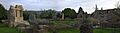
The Roman settlement of Helvia Recina
See also
 In Spanish: Macerata para niños
