Punta de Astorg facts for kids
Quick facts for kids Punta de Astorg |
|
|---|---|

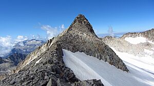
View of Pico Maldito (centre) and Punta de Astorg (right) from Aiguille Juncadella, in June
|
|
| Highest point | |
| Elevation | 3,354 m (11,004 ft) |
| Prominence | 157 m (515 ft) |
| Naming | |
| Etymology | Count Réné d'Astorg |
| English translation | Point of Astorg |
| Language of name | Lua error in Module:ISO_639_name at line 108: attempt to index local 'data' (a nil value). |
| Geography | |
| Location | Province of Huesca, Aragon, Spain |
| Parent range | Spanish Pyrenees |
| Geology | |
| Age of rock | Hercynian |
| Climbing | |
| First ascent | 9 July 1901 |
| Easiest route | via the Renclusa Refuge and the Aneto glacier |
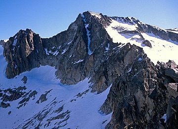
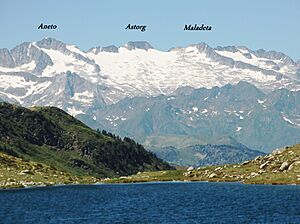
Punta de Astorg (also called Aragonese: Punta d'Astorg or Spanish: Punta de Astorg) is a tall mountain peak in the Spanish Pyrenees. It stands at 3,354 meters (about 11,000 feet) above sea level. This makes it one of the highest peaks in the Pyrenees mountain range. It's part of the Maladeta massif, which is a group of mountains. Punta de Astorg is the second highest peak in its group, right after Aneto, which is even taller at 3,404 meters. It's also the fourth highest peak in the entire Pyrenees!
Contents
How Punta de Astorg Got Its Name
This mountain peak used to be called Lerilica Peak. But that changed on July 9, 1901. On that day, a French mountain climber named René d'Astorg (1860-1940) became the first person to reach its top. After his successful climb, the peak was renamed in his honor.
Punta de Astorg is the highest point of a long mountain ridge. This ridge is called Cresta Maldito in Spanish. That name means "cursed ridge" in English. The name came about because some of the first attempts to climb the peaks in the Maladeta massif, especially Aneto, led to accidents on the glaciers. One sad event happened in 1824. A guide named Pierre Barrau died in a deep crack in the Maladeta glacier. This made the local guides very scared. They already worried about the dangers of the glacier. After this accident, they became even more afraid. They started to believe the mountain range was "cursed."
Geography of Punta de Astorg
Where Punta de Astorg is Located
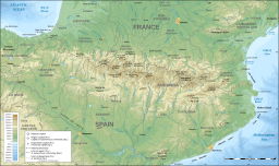
Punta de Astorg is a peak in the Maladeta massif. This area is part of the Posets–Maladeta Natural Park. The peak sits on a ridge that separates two valleys. To the south is the Vallibierna valley, and to the north is the Benasque valley.
From the summit, you can see the beautiful Coronas lakes. You can also see Ibon Maldito, a lake that is 2,970 meters high. This lake is the third highest in the Pyrenees mountains. To the west of the peak is Lake Cregüena.
The Aneto Glacier
On the north side of Punta de Astorg is the Aneto glacier. This is the largest glacier in the Pyrenees. In 2007, it covered an area of about 64 hectares (158 acres). However, this glacier is shrinking very fast. This is happening because of climate change. Over the last 100 years, the glacier has lost more than half of its size. Scientists believe it might disappear completely by the year 2050.
How the Mountain is Shaped
Punta de Astorg is located between two other important peaks in the Maladeta massif. These are the Maladeta and Aneto. A smaller peak called Coronas (3,293 meters) separates Punta de Astorg from Aneto.
Punta de Astorg is the highest point of the Cresta Maldito ridge. This ridge is also known as Cresta del Medio, which means "Middle Ridge." It's called this because it's in the middle of Aneto and Maladeta. This ridge is narrow and stretches for more than 600 meters. It stays at an altitude of almost 3,350 meters. At one end is Pico Maldito (3,354 meters), and at the other is Pico del Medio (3,346 meters).
Punta de Astorg is considered a very important peak. This is because it rises 157 meters above the lowest point connecting it to a higher peak. This measurement is called its "peak height."
History of Climbing Punta de Astorg
The first time anyone climbed Punta de Astorg was on July 9, 1901. The climbers were René d'Astorg and Henri Brulle. They had two guides with them: Célestin Passet and François Bernat-Salles. It's interesting that this peak was climbed quite late. Other mountains of similar height, like Monte Perdido, were climbed a century earlier. Aneto was climbed 60 years before Punta de Astorg.
A famous writer named Henri Béraldi wrote about this first climb in his book Cent Ans aux Pyrénées. He described the adventure:
On Sunday, July 8, Brulle and d'Astorg met their guides, Célestin and Bernat, in Luchon. They climbed to the Port de Venasque in just over two hours and slept at Cabellud's. On Monday, they started climbing at 5:20 AM. They crossed the Plan des Etangs and the Portillon. The glacier had no deep cracks, and they began to climb the Pic du Milieu (Middle Peak) right up its center. The big crack at the bottom of the glacier was easy to cross. But the icy rocks above needed great care. They reached the true summit, which looked like a huge stone monument. It had a large block hanging over, with a tall, thin stone on top. Only the Pie du Portillon d'Oô was more amazing. The climbers stood on the tall stone, completing the climb. They came down the same way, taking extreme care because it was truly dangerous. If the weather hadn't been bad, they would have tried to follow the ridge to Col Coroné. There were likely big challenges ahead.
See also
 In Spanish: Punta de Astorg para niños
 | Ernest Everett Just |
 | Mary Jackson |
 | Emmett Chappelle |
 | Marie Maynard Daly |


