
Pyrmont, New South Wales facts for kids
Quick facts for kids PyrmontSydney, New South Wales |
|||||||||||||||
|---|---|---|---|---|---|---|---|---|---|---|---|---|---|---|---|
_(cropped).jpg)
Pyrmont from Pirrama Park
|
|||||||||||||||

Pyrmont
Location in New South Wales
|
|||||||||||||||
| Postcode(s) | 2009 | ||||||||||||||
| Elevation | 26 m (85 ft) | ||||||||||||||
| Area | 1 km2 (0.4 sq mi) | ||||||||||||||
| Location | 2 km (1 mi) west of Sydney CBD | ||||||||||||||
| LGA(s) | City of Sydney | ||||||||||||||
| Parish | St Andrew | ||||||||||||||
| State electorate(s) | Sydney | ||||||||||||||
| Federal Division(s) | Sydney | ||||||||||||||
|
|||||||||||||||

Pyrmont is a lively inner-city suburb of Sydney, Australia. It's located just 2 kilometres southwest of the main city centre. Pyrmont is also part of the exciting Darling Harbour area. In 2011, it was known as Australia's most crowded suburb!
Long ago, Pyrmont was a very busy industrial area. It had many wharves (places where ships dock), shipbuilding yards, factories, and huge wool storage buildings. But over time, these industries moved away, and the area became quieter. In recent years, Pyrmont has changed a lot. Many new homes and offices have been built, bringing lots of people back to live and work there.
Contents
Pyrmont's Past: A Journey Through Time
The land we now call Pyrmont was originally known as Pirrama by the Dharug people, who are the traditional owners of this area.
How Pyrmont Got Its Name
Pyrmont was named after a natural mineral spring that bubbled cold water out of a rock. This was similar to a famous spring in Bad Pyrmont, a town near Hanover, Germany. In 1795, a man named Thomas Jones was given 55 acres of land on this peninsula. Later, in 1799, Captain John Macarthur, a famous wool pioneer, bought the land.
Pyrmont's Famous Quarries
Pyrmont was a great place for quarries because of its excellent sandstone. This stone was used to build many important buildings in Sydney. Charles Saunders became the biggest quarry owner, with three quarries operating from 1853. His family continued this work until about 1931.
The Scottish workers who worked for Saunders gave the quarries funny nicknames: Paradise, Purgatory, and Hell Hole. These quarries were also special because they were the first in Australia to use steam-powered equipment! Saunders Street, near where the Paradise quarry used to be, is named after Charles Saunders.
Former_Methodist_Chapel_Harris_Street_Pyrmont.jpg)
From Churches to Kindergartens
Pyrmont was home to the first Presbyterian Church in the colony, built in 1864. Later, in the 1870s, a small Methodist chapel was built on land owned by Charles Saunders. In the 1920s, this chapel was turned into the Maybanke Free Kindergarten. It was named after Maybanke Anderson, a woman who worked hard for women's rights and education. This kindergarten was still helping children in 2018!
Pyrmont grew into a busy place for working-class families and port workers. A large sugar factory, run by CSR Limited, was a major employer. By 1900, about 30,000 people lived in Pyrmont. The first Pyrmont Bridge opened in 1858. A bigger bridge with a part that could swing open for ships was built in 1902. This bridge is now used only by people walking and cycling. In the 1970s, local residents worked together to protect much of the suburb from a new road.
A Quiet Period
After World War II, many industries in Pyrmont closed down. People started moving to other suburbs, and the population of Pyrmont dropped a lot. By 1978, only about 1,800 people lived there, and by 1990, it was down to around 900.
Pyrmont's Big Comeback
In the 1990s, the government started a plan called the "Better Cities Program" to help Pyrmont become lively again. New groups were created to make the area better. This led to a huge increase in population, with about 13,000 people living there by 2004. Many businesses also moved back, bringing 22,000 employees!
Today, most of the old industrial buildings are gone. In their place, you'll find modern homes and offices. The old sugar factory, for example, was restored and now holds homes and offices.
After this big change, Pyrmont became much more multicultural. In 2021, only about 40% of residents were born in Australia, with many others coming from countries like China, England, and India.
Cool Places to See in Pyrmont
Pyrmont has some really interesting buildings and places with a lot of history.
- The Pyrmont Fire Station, built in 1907, is a beautiful building made of brick and sandstone. It has a unique style with fancy details.
- The public school in John Street, built in 1891, is another historic brick building with a bell tower and a slate roof. Today, it's used as a childcare centre and a community hub.
- Union Square is a special historic area. It includes the Post Office, a pub called The Harlequin Inn, old bank buildings, and many historic homes and terraces.
Historic Sites in Pyrmont

Pyrmont has several places that are officially listed for their historical importance, including:
- The Pyrmont Post Office on Harris Street.
- The Glebe Island Bridge near Bank Street.
- The charming Old Pyrmont Cottages on Cross Street.
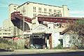
- The Pyrmont and Glebe Railway Tunnels, part of the old goods railway.
- The Royal Edward Victualling Yard on Pirrama Road.
What's Happening in Pyrmont Today?
Pyrmont is a hub of activity!
- The Star casino is a huge entertainment complex right on the Darling Harbour waterfront.
- The Sydney Fish Market is a famous spot where you can find all sorts of fresh seafood.
- Jacksons Landing is a modern area with homes and businesses at the northern tip of Pyrmont.
Many big companies have their main offices in Pyrmont, like Vodafone, Accenture Australia, Network 10, and Google. You can also find several radio stations here, including Nova 96.9, Smooth 95.3, and 2SM.
Pyrmont's Growing Population
Pyrmont has seen its population grow quite a bit over the years:
- 2001: 7,861 people
- 2006: 11,088 people
- 2011: 11,618 people
- 2016: 12,813 people
- 2021: 12,658 people
In 2021, about 40% of people living in Pyrmont were born in Australia. Other common countries of birth included China, England, India, and Thailand. English was the main language spoken at home for about 52% of residents, but many other languages like Mandarin, Cantonese, and Spanish were also spoken. Most homes in Pyrmont are flats or apartments.
Getting Around Pyrmont
Pyrmont has many ways to get around, making it easy to explore!
Roads and Bridges
The Pyrmont Bridge is a special swing bridge that connects Pyrmont to the city centre, and it's only for people walking and cycling. The Western Distributor is a major road that goes through Pyrmont, connecting it to the city and then to the North Shore via the Sydney Harbour Bridge. The famous Anzac Bridge, a large cable-stayed bridge, also links Pyrmont to Rozelle.
Light Rail and Ferries

The Inner West Light Rail has five stops in Pyrmont: Pyrmont Bay, The Star, John Street Square, Fish Market, and Wentworth Park. You can also catch a ferry from the Pyrmont Bay ferry wharf. Buses are another easy way to travel around the area.
Pyrmont used to have a tram network, which closed in 1958. There was also a monorail that ran between the city and Darling Harbour, crossing the Pyrmont Bridge, from 1988 to 2013.
Future Train Station
A new rapid transit train station called Pyrmont is planned to be built as part of the Sydney Metro West project, which will make getting around even easier!
Pyrmont's Green Spaces
Pyrmont has many lovely parks where you can relax and play.

- St Bartholomew's Park is a small park created in 1954. It's named after a church that used to be nearby.
- Pirrama Park (also known as Pyrmont Point Park) is a large park at the very tip of the peninsula. It used to be a base for the Water Police, but now it's a beautiful 1.8-hectare space with cafes, barbecue areas, and playgrounds for kids.
- Giba Park is located on top of a cliff, offering great views over Pirrama Park.
- Waterfront Park is another park located near the western edge of the suburb.
Other parks in Pyrmont include The Knoll, Carmichael Park, Jones Street Pocket Park, Ballaarat Park, Metcalfe Park, Pyrmont Bay Park, Bank Street Foreshore Park, and Refinery Square.
Images for kids
-
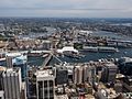
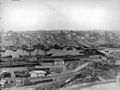
View of Pyrmont from Sydney Tower
-
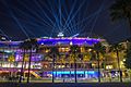
The Star during Vivid Sydney 2015
-
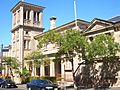
Pyrmont Public School, John Street
-
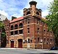
Pyrmont Fire Station, Pyrmont Street
-
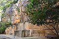
Charles Saunders's Paradise Quarry near Saunders Street
-
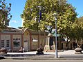
Union Square
-
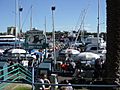
Sydney Fish Markets
-
Pyrmont Bridge in 1900
-
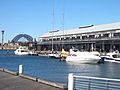
Pyrmont wharves
-
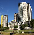
New apartments in Pyrmont
-
Pyrmont Power Station (chimneys removed)
-
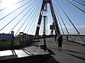
Pyrmont end of ANZAC Bridge, rest area where bicycle/pedestrian ramp joins the bridge from Quarry Master Drive (between Bank St and Saunders St).
-
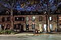
Sandstone terrace houses on Harris Street


Pyrmont_Fire_Station-1.jpg)
Saunders_Quarry-1.jpg)


