Quentin, Pennsylvania facts for kids
Quick facts for kids
Quentin, Pennsylvania
|
|
|---|---|

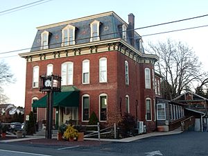
Quentin Tavern on W. Main St.
|
|
| Country | United States |
| State | Pennsylvania |
| County | Lebanon |
| Townships | West Cornwall |
| Area | |
| • Total | 1.09 sq mi (2.83 km2) |
| • Land | 1.09 sq mi (2.83 km2) |
| • Water | 0.00 sq mi (0.00 km2) |
| Elevation | 560 ft (170 m) |
| Population
(2020)
|
|
| • Total | 755 |
| • Density | 691.39/sq mi (266.87/km2) |
| Time zone | UTC-5 (Eastern (EST)) |
| • Summer (DST) | UTC-4 (EDT) |
| ZIP code |
17083
|
| FIPS code | 42-63160 |
| GNIS feature ID | 1184550 |
Quentin is a small community in Lebanon County, Pennsylvania, United States. It is also known as a census-designated place (CDP). This means it's an area identified by the government for gathering statistics, but it's not an officially incorporated town.
Quentin was named after Quentin Roosevelt. He was the youngest son of President Theodore Roosevelt. In 2020, about 755 people lived in Quentin.
Contents
Why Quentin Got Its Name
The community was first called "Bismark." This name was a local way of spelling the name of Otto von Bismarck. He was a famous German leader.
In October 1920, the name was changed. The community wanted to honor Quentin Roosevelt. He was a fighter pilot who died during World War I.
Where is Quentin Located?
Quentin is found in the southern part of Lebanon County, Pennsylvania. It is in the northeast corner of West Cornwall Township. The borough of Cornwall is right next to it on the east side.
Main Roads in Quentin
Several important roads pass through or near Quentin:
- U.S. Route 322 runs along the southwest edge of Quentin. This road goes west about 26 miles to Harrisburg. Harrisburg is the capital city of Pennsylvania. It also goes southeast about 17 miles to Ephrata.
- Pennsylvania Route 72 goes through the eastern part of Quentin. It leads north about 4 miles to Lebanon. Lebanon is the main town in the county. Southward, it goes about 19 miles to Lancaster.
- Pennsylvania Route 419 crosses through the middle of Quentin. It travels east about 8 miles to Schaefferstown.
Quentin's Size and Waterways
The U.S. Census Bureau says Quentin covers about 1.09 square miles (2.83 square kilometers). All of this area is land. A small stream flows north through Quentin. This stream is a branch of Snitz Creek. It eventually flows into Quittapahilla Creek.
Who Lives in Quentin?
| Historical population | |||
|---|---|---|---|
| Census | Pop. | %± | |
| 2020 | 755 | — | |
| U.S. Decennial Census | |||
In 2000, there were 529 people living in Quentin. By 2020, the population had grown to 755 people.
Community Makeup
- Most people living in Quentin are White.
- A small number of residents are African American or Asian.
- Some people are from other backgrounds or identify with two or more races.
- A small percentage of the population is Hispanic or Latino.
Households and Families
In 2000, there were 223 households in Quentin. A household is a group of people living together. About 28% of these households had children under 18 years old. Most households were married couples living together. Some households had a single female parent. About 25% of households were individuals living alone.
The average household had about 2.37 people. The average family had about 2.83 people.
Age Groups in Quentin
The population in Quentin includes people of all ages:
- About 19.8% of residents were under 18 years old.
- About 7.2% were between 18 and 24 years old.
- The largest group, about 33.1%, was between 25 and 44 years old.
- About 25.5% were between 45 and 64 years old.
- About 14.4% were 65 years old or older.
The average age in Quentin in 2000 was 39 years.
See also
 In Spanish: Quentin (Pensilvania) para niños
 | Calvin Brent |
 | Walter T. Bailey |
 | Martha Cassell Thompson |
 | Alberta Jeannette Cassell |


