
Rainbow Valley Conservation Reserve facts for kids
Quick facts for kids Rainbow Valley Conservation ReserveNorthern Territory |
|
|---|---|
|
IUCN Category V (Protected Landscape/Seascape)
|
|

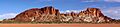
Sunset light on the bluff at a sharp angle
|
|

Rainbow Valley Conservation Reserve
Location in Northern Territory
|
|
| Nearest town or city | Alice Springs |
| Established | 1990 |
| Area | 24.83 km2 (9.6 sq mi) |
| Visitation | 6,800 (in 2014) |
| Managing authorities | the Twertentyeye group of Upper Southern Arrernte people and the Parks and Wildlife Commission of the Northern Territory (PWCNT) |
| Website | Rainbow Valley Conservation Reserve |
| See also | Protected areas of the Northern Territory |
Rainbow Valley Conservation Reserve is a special protected area in the Northern Territory of Australia. It is located south of Alice Springs. This reserve was created in 1990 to protect amazing sandstone rock formations. It also protects important Aboriginal art, tools, and sacred natural objects. The reserve covers about 24.83 square kilometers (9.59 square miles).
The main rock formation in Rainbow Valley looks like a rainbow. It has different colored layers of sandstone. The rock that is rich in iron looks red and orange. This color stands out against the lighter sandstone, which turns pale yellow or gold when the sun shines on it late in the day. The local Aboriginal people, the Twertentyeye group of Upper Southern Arrernte people, call this main formation Wurre. It is a very important part of their homeland, which they call Imarnte. Since 2008, the Twertentyeye people and the Parks and Wildlife Commission of the Northern Territory (PWCNT) have worked together to manage the reserve. This was the first conservation reserve to have such a joint management plan.
Contents
Exploring Rainbow Valley
Rainbow Valley is about 75 kilometers (47 miles) south of Alice Springs. You can reach it by taking a turn off the Stuart Highway. The last 22 kilometers (14 miles) to the reserve are on an unsealed dirt road. Because some parts of the road are sandy, it is best to use a 4WD vehicle. This is especially true for the final 1.4 kilometers (0.87 miles) around the claypan.
The reserve is in a very dry part of Australia. Rain does not fall often, and droughts are common. Alice Springs, the closest town with weather records, gets only about 286 millimeters (11.3 inches) of rain each year. But more than 3000 millimeters (118 inches) of water evaporate each year! There are no rivers or lakes that stay full all the time. However, there is water underground in an aquifer. Also, one rockhole can hold rainwater for a long time. This was a very important water source for the Aboriginal people after heavy rains.
The Amazing Rocks of Rainbow Valley
The cliffs and rocks in Rainbow Valley are made of Hermannsburg Sandstone. This rock is about 350 million years old. Deeper underground, there is another type of rock called Mereenie Sandstone. You can see this rock in the James Range, a mountain range south of the reserve. You can find different rock features here, like cracks, honeycomb-shaped holes, and iron-stained sandstone. You might even see some fossils!
These sandstone rocks are very delicate. Human touch can easily damage them. So, climbing on or disturbing the rock formations is not allowed. The flat, muddy areas called claypans are also delicate. Visitors should stay off them unless they are completely dry and they have a special permit.
The beautiful colored bands in the rocks were formed a long, long time ago. Back then, this dry region used to be much wetter. Heavy rains would dissolve the reddish, iron-rich sandstone. Then, during dry seasons, these dissolved minerals would harden on the surface, making the rocks a deeper red. The dark red rock on top, called caprock, has the most iron. It is also stronger and resists erosion better than the lighter colored sandstone layers. This helps the formations stay standing for a long time.
There is a marked walking trail that leads to another cool rock formation called Mushroom Rock. You can often see fairy martin nests high up on the rock walls there.
Plants and Animals

Rainbow Valley is home to more than 400 different kinds of plants. You can find spinifex grasslands, acacia shrubs, and coolibah trees. Mulga trees grow close to the sandstone formations and even on top of them. On the east side of the main formation, you will see more desert oaks.
A special shrub called eremophila Rainbow Valley grows here. It is listed as vulnerable, meaning it is at risk of disappearing. This plant only grows in a very small area and is not protected anywhere else. Another rare shrub, Daviesia arthropoda, also grows on the sand dunes in the reserve.
The reserve is also home to many animals:
- 110 types of birds
- 20 types of mammals
- 46 types of reptiles
- 3 types of frogs
Some animals are very important in the local Aboriginal culture, like emus, bats, dingoes, and honeypot ants. Bat species include the Gould's wattled bat and the lesser long-eared bat.
Migratory black, brown, and pied honeyeaters use the grevillea and eremophila shrubs to build their nests. The white-winged fairywren lives in the zygochloa and spinifex grasslands. Some birds, like the grey falcon, redthroat, and red-tailed black cockatoo, are considered near threatened.
The euro is the mammal you are most likely to see. The black-flanked rock-wallaby is listed as vulnerable and near threatened. It is the only mammal in the reserve with a special conservation listing. You might also spot a thorny devil or a trilling frog living here.
Aboriginal Culture and History
More than forty Aboriginal archaeological sites have been found and recorded in Rainbow Valley. These sites include petroglyphs (pictures carved into rock), pictographs (pictures painted on rock), grinding stones, stone tools, quarries, and old camp sites. All these important archaeological sites are in a restricted area. You need special permission and a guide to visit them.
South of the main sandstone formation, there is a large rock called Ewerre by the Twertentyeye people. This rock, and all the area within 50 meters (164 feet) around it, is a sacred site. The black rocks on the north side of the main formation are also very important natural objects. They should not be moved from where they are.
To respect both the Aboriginal culture and the need to protect the area, visitors can only explore certain parts of the reserve. These include the special viewing and camping areas on the southwest side of the claypan. You can also walk along the trail to Mushroom Rock or other officially marked trails. All other areas, including the claypan, are restricted. You need a guide to enter them.
Visitor Facilities
If you want to camp at Rainbow Valley, there are two special camping areas. You will need to pay a camping fee when you arrive. The camping areas have gas barbecues, firepits, picnic tables, and pit toilets.
Images for kids
-
The main sandstone formation seen from the claypan
