
Ranaghan facts for kids
Quick facts for kids
Ranaghan
Ranaghan
|
|
|---|---|
|
Town
|
|

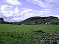
Hills of Ranaghan
|
|

Ranaghan
Location in Ireland
|
|
| Country | Ireland |
| Province | Leinster |
| County | County Westmeath |
| Elevation | 128 m (420 ft) |
| merged with Castlepollard | |
| Time zone | UTC+0 (WET) |
| • Summer (DST) | UTC-1 (IST (WEST)) |
| Irish Grid Reference | N463640 |
Ranaghan is a townland and an important archaeological site. It is located in County Westmeath, Ireland.
Ranaghan: A Place of Ancient Forts
Ranaghan is found southwest of Lough Lene. It sits on high ground, which is why there are many ancient forts here. One of the most famous forts in the area is Randoon (also called Randún). It is located between the towns of Castlepollard and Collinstown. People believe that Turgesius, a famous Viking leader, once lived and ruled in this area.
What is a Ringfort?
Ringforts are special fortified settlements. They were built a long time ago, mostly during the Early Medieval Period in Northern Europe, especially in Ireland. They are also known by different names in old Irish stories. These names include ráth, caiseal, cathair, and dún.
- A ráth (pronounced "rah") was a fort made from earth. Ranaghan's name comes from this word!
- Caiseal (pronounced "cash-el") and cathair (pronounced "cah-her") were forts built using stone. Caiseal was common in northwestern Ireland, and cathair in southwestern Ireland.
- A dún was a more important site. It was usually the home of a local chief or ruler. The fort of Randoon/Randún is an example of a dún.
Finding Forts Around Lough Lene
It is hard to find very old maps or records from the Early Medieval Period in Ireland. This makes it tricky to know exactly when Irish ringforts were built. However, the areas around Lough Lene are full of these forts. Lough Lene means "fertile soil," and the land around it is very rich. This includes places like Collinstown, Glenidan, Comerstown, and Ranaghan. The many ringforts show that this area was important and had good land for farming long ago.
-
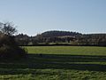
Gillardstown: view to Ranagahan Hills
-
Overgrown ringforts, Ranaghan Hills
-
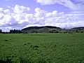
Gillardstown and Ranagahan Hills


