
Rancho Las Virgenes facts for kids
Rancho Las Vírgenes was a very large piece of land, about 17,760 acres (71.9 km²), given as a land grant in what is now western Los Angeles County, California. This rancho was located in the Santa Monica Mountains and Simi Hills. Today, the land that was once Rancho Las Vírgenes includes cities like Agoura Hills, Oak Park, and Westlake Village.
The first grant for this land was given in 1802 by Spanish Governor José Joaquín de Arrillaga to Miguel Ortega. However, after Ortega died in 1809, the land was left empty. Later, in 1834, Nemecio Domínguez and Domingo Carrillo received a new land grant from the Mexican government. The name Nuestra Señora la Reina de las Vírgenes means "Our Lady the Queen of the Virgins."
Contents
History of the Rancho

The area of Rancho Las Vírgenes was originally home to the Tongva Native American people. Their village here was called Wisyáxnga, which means "place of the pine."
Early Spanish Grant
In 1800, Bartholomé Miguel de Ortega received a temporary Spanish land grant for this area. It was known by several names, including Rancho Las Vírgenes. After Miguel Ortega passed away in 1809, his family went back to Pueblo de Los Ángeles. By 1817, the rancho was considered abandoned. Since Ortega's grant was only temporary, the land was legally empty. The Franciscans from Mission San Fernando Rey de España then asked the governor if they could use the land for their cattle.
Mexican Land Grant
In 1833, Nemesio Domínguez and Domingo Antonio Ygnacio Carrillo asked Governor Figueroa for the land known as Las Vírgenes. They explained that the mission did not need the land and that it had been empty since Ortega's death. In 1834, they were officially granted Rancho Las Vírgenes.
A few years later, in 1837, Governor Alvarado added more land to the Las Vírgenes grant. This addition, called Triunfo, was given to Nemecio's father, José Maria Dominguez. A new map of the rancho was drawn at this time.
The Reyes Family Takes Over
In 1845, Maria Antonia Machado de Reyes (1792–1863) bought Rancho Las Vírgenes. She was the niece of José Maria Dominguez. Maria Antonia was a widow with 14 children. Her husband, José Jacinto Reyes, was the son of a well-known soldier named Juan Francisco Reyes.
California Becomes Part of the U.S.
After the Mexican-American War, California became part of the United States in 1848. The Treaty of Guadalupe Hidalgo stated that the U.S. would respect the existing land grants. To make these grants official under U.S. law, owners had to file a claim with the Public Land Commission.
Maria Antonia Machado de Reyes filed her claim in 1852. Her claim was approved in 1854, and the U.S. District Court confirmed it in 1857. The land was officially recognized as hers in 1883, covering about 8,885 acres (35.96 km²).
The final size of the rancho was smaller than the original grant. This happened because of a misunderstanding of the 1837 map. The U.S. government thought the excluded land was public land. This allowed other settlers to move into the area, and their claims were officially documented after 1896.
José Maria Dominguez had given his part of the rancho to his son, Jose Apolonio Dominguez. Jose Apolonio then left it to his daughter, Dominga Dominguez. Dominga later sued some settlers to get back parts of Rancho Las Vírgenes. The U.S. Supreme Court decided that even though the original grant was valid, it had to be officially claimed with the Land Commission to be recognized by the U.S. government.

Historic Sites of the Rancho
These are some important old places connected to Rancho Las Vírgenes:
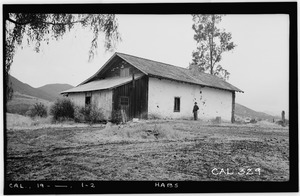
- Reyes Adobe: Jose Paulino Reyes, a son of Maria Antonia Machado de Reyes, built this adobe home around 1850. Today, it is owned by the City of Agoura Hills.
- Vejar Adobe: This two-story adobe building was built around 1850 by Juan Crisostomo Vejar. He married Maria Engracia Reyes, who was Maria Antonia Machado de Reyes's daughter. The Vejar Adobe was a stop along the Butterfield Overland Stage route in the 1860s and was known as Vejar Station. It stood in Agoura until the early 1900s, when it was taken down.
