Rancho de las Pulgas facts for kids

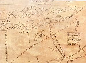
Rancho de las Pulgas was a huge piece of land given by Spain in 1795. It was about 35,240 acres (142.6 square kilometers). This land is now part of San Mateo County, California. The grant was given to José Darío Argüello.
The name "Rancho de las Pulgas" means "Ranch of the Fleas." It was likely named after a village of the local Lamchin people. This Native American group lived in the area.
The land stretched from San Mateo Creek in the north to San Francisquito Creek in the south. It also went about one league (around 3 miles) from San Francisco Bay towards the hills. Today, this area includes cities like San Mateo, Belmont, San Carlos, Redwood City, Atherton, and Menlo Park.
Contents
History of the Rancho Land Grant
In 1795, the Spanish Governor of California, Diego de Borica, first gave the Las Pulgas land to José Darío Argüello. This was a temporary grant. José Darío Argüello had several sons, including Luis Antonio Argüello and Santiago Argüello.
Years later, in 1835, Mexico controlled California. The Mexican Governor, José Castro, officially granted the Rancho de las Pulgas. This time, it was given to Maria Soledad Ortega de Argüello. She was the widow of Luis Antonio Argüello, and the land was for her and her children.
Land Ownership Changes
After the Mexican–American War ended in 1848, California became part of the United States. The Treaty of Guadalupe Hidalgo said that the US would respect the existing land grants. This meant the Argüello family's claim to Rancho de las Pulgas should be honored.
In 1852, the Argüello family filed a claim for their land. They asked for twelve square leagues. However, the US Public Land Commission only approved a claim for four square leagues. This decision was upheld by the US Supreme Court.
Surveying the Rancho Boundaries
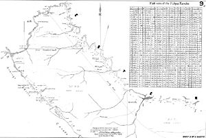
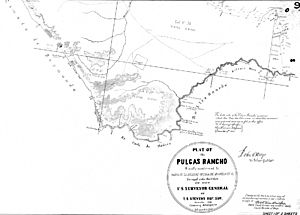
In 1857, the land was officially surveyed and given a "patent." A patent is like a formal deed from the government. The patent was given to Maria Soledad Ortega de Argüello and other family members. Their lawyer, Simon Monserrat Mezes, also received a share.
The patent stated the land was 35,240 acres. This was almost double the size of the original four-league grant. It also went against what the US Supreme Court had ruled. This caused problems because the boundaries of Rancho de las Pulgas overlapped with another nearby land grant, Rancho Cañada de Raymundo. It took an Act of Congress in 1878 to finally fix these overlapping boundaries.
Alameda de las Pulgas Road
Alameda de las Pulgas is a modern road that runs for almost 10 miles. It connects many of the cities that were once part of the original Rancho de las Pulgas. These cities include San Mateo and Menlo Park.
This area has many suburban homes and some small businesses along the road. People often just call the road "the Alameda." In Spanish, "alameda" means a street lined with trees. So, "Alameda de las Pulgas" means "Avenue of the Fleas."
The main village of the Lamchin people, an Ohlone tribe, was in the San Carlos area. This was before Spanish settlers arrived. Their village was called "Cachanigtac." This name seems to have a word for small insects. The Spanish missionaries translated this as "las Pulgas," or "the Fleas."
- For more information about the Argüello family, see Argüello.
 | Claudette Colvin |
 | Myrlie Evers-Williams |
 | Alberta Odell Jones |


