Atherton, California facts for kids
Quick facts for kids
Atherton, California
|
|||
|---|---|---|---|
| Town of Atherton | |||
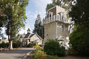
Holbrook-Palmer Park
|
|||
|
|||
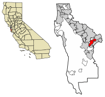
Location of Atherton in San Mateo County, California
|
|||
| Country | United States | ||
| State | California | ||
| County | San Mateo | ||
| Incorporated | September 12, 1923 | ||
| Named for | Faxon Dean Atherton | ||
| Area | |||
| • Total | 5.05 sq mi (13.07 km2) | ||
| • Land | 5.02 sq mi (12.99 km2) | ||
| • Water | 0.03 sq mi (0.08 km2) 0.63% | ||
| Elevation | 59 ft (18 m) | ||
| Population
(2020)
|
|||
| • Total | 7,188 | ||
| • Density | 1,433.01/sq mi (553.28/km2) | ||
| Time zone | UTC−8 (Pacific) | ||
| • Summer (DST) | UTC−7 (PDT) | ||
| ZIP Code |
94027
|
||
| Area code | 650 | ||
| FIPS code | 06-03092 | ||
| GNIS feature IDs | 1657960, 2411651 | ||
Atherton (/ˈæθərtən/ ath-ƏR-tən) is a town in San Mateo County, California, United States. About 7,188 people lived there in 2020. Atherton is known for being a very wealthy area. In fact, its ZIP Code is often ranked as having the highest cost of living in the United States. In 2023, the average home price in Atherton was about $7,950,000. The town's rules usually allow only one single-family home per acre. Also, you won't find sidewalks here.
Contents
What is the History of Atherton?
The land where Atherton now stands was once part of a large Spanish land grant called Rancho de las Pulgas.
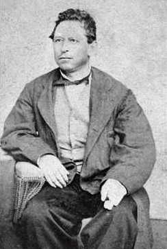
In the 1860s, the area was called Fair Oaks. Later, in 1923, the town was renamed Atherton. This was done to honor Faxon Atherton, an important landowner from the 1800s.
Why Did Atherton Sue Caltrain?
Atherton has been involved in lawsuits about train projects. The town strongly opposed a plan to add electric lines for the Caltrain commuter railroad. Caltrain serves cities in the San Francisco Peninsula and Silicon Valley.
Residents were worried that the electric lines would mean cutting down many trees. They also feared that closing two road crossings would divide the town. They thought "newer, cleaner, more efficient diesel trains" would be better than old electric lines.
In 2015, Atherton sued Caltrain. The town said Caltrain's environmental study was not good enough. Even though a judge later sided with Caltrain, Atherton continued to express its concerns. The California State Legislature eventually passed a law to help fund the train project.
The Caltrain station in Atherton closed in 2020.
How Does Atherton Manage Land and Housing?
Atherton is known as one of the wealthiest towns in the United States. This is partly because of its rules about land use. Most homes are large and spread out, with at least one acre of land per home. There are no stores, restaurants, or grocery shops in Atherton. You also won't find sidewalks in the town.
For a long time, the town's rules only allowed one single-family home per acre. This helped make home prices very high. Many residents did not want more housing built. However, a new California law called SB 9 changed some of these rules in 2022. This law allows more homes to be built on properties.
In 2022, Atherton stopped a plan to build 131 new apartments. People who want more housing have criticized Atherton for its strict rules. In 2022, California Governor Gavin Newsom mentioned Atherton for its housing policies. The mayor said the town was working on building affordable homes for school staff and teachers.
In 2023, the Atherton City Council approved a plan for 348 new homes. These homes will be for people with different income levels. The town's main goal for land use is to keep its "scenic, rural, thickly wooded residential area with abundant open space" feel.
Where is Atherton Located?
Atherton covers about 5 square miles (13 square kilometers). Most of this area is land, with a small part being water.
The town is located about 2 miles (3 kilometers) southeast of Redwood City. It is also about 18 miles (29 kilometers) northwest of San Jose. Atherton is part of the larger San Francisco Bay Area.
What is the Population of Atherton?
Atherton is not very diverse compared to other cities in Silicon Valley. About 75% of the people living there are non-Hispanic white.
Population in 2010
In 2010, Atherton had a population of 6,914 people. Most people (94.4%) lived in households. There were 2,330 households, and about 33.8% of them had children under 18. The average household had 2.80 people.
The median age in Atherton was 48.2 years. The median household income was very high, over $250,000. About 5.1% of the population lived below the poverty line.
Population in 2020
In 2020, the population of Atherton was 7,193 people. There were 2,252 households. About 89.2% of homes were owned by the people living in them.
The racial makeup was 75% White, 23% Asian, and 1.7% African American. About 7.5% of the people were Hispanic or Latino. The median age was 49 years. The median household income was still very high, over $250,000. About 2.6% of the population lived below the poverty line.
In 2022, Atherton was ranked as the most expensive ZIP code in the United States for the fourth year in a row. The average home price was about $7,900,000.
What Arts and Culture are in Atherton?
Atherton has many active community groups. These include the Atherton Heritage Association and the Atherton Arts Committee. There are also groups like the Friends of the Atherton Community Library.
The Menlo Circus Club is a private club in town. It has tennis courts, a swimming pool, stables, and a riding ring.
The Holbrook-Palmer Estate is a 22-acre public park. It was once a large farm and was given to the town in 1958. It is now listed on the National Register of Historic Places because of its architecture.
The town also has the Atherton Public Library, which is part of the San Mateo County Libraries.
What Schools are in Atherton?
Atherton has several public and private schools.
Public Schools
Atherton does not have its own public school system. Instead, different parts of the town are served by various school districts:
- Elementary Schools: Encinal, Las Lomitas, and Laurel are elementary schools.
- Elementary and Middle School: Selby Lane is both an elementary and a middle school.
- High School: Menlo-Atherton is the local high school.
Private Schools
- Sacred Heart is a private school that includes elementary, middle, and high school levels.
- Menlo School is another private school for middle and high school students.
Colleges
- Menlo College is a private four-year college located in Atherton.
Who are Some Famous People from Atherton?
Many well-known people have lived in Atherton. Here are a few:
- Paul Allen, co-founder of Microsoft
- Marc Andreessen, co-founder of Netscape
- Stephen Curry and Ayesha Curry, NBA star and actress
- Ty Cobb, famous baseball player
- Douglas Engelbart, inventor of the computer mouse
- Willie Mays, Hall of Fame baseball player
- Jerry Rice, Hall of Fame football player
- Eric Schmidt, former CEO of Google
- Charles R. Schwab, founder of Charles Schwab Corporation
- Shirley Temple, child movie star and diplomat
- Meg Whitman, former CEO of Hewlett-Packard and eBay
Images for kids
See also
 In Spanish: Atherton (California) para niños
 | Bayard Rustin |
 | Jeannette Carter |
 | Jeremiah A. Brown |


