Randall Island facts for kids

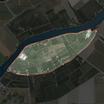
USGS aerial imagery of Randall Island
|
|
| Geography | |
|---|---|
| Location | Northern California |
| Coordinates | 38°20′25″N 121°33′03″W / 38.34028°N 121.55083°W |
| Adjacent bodies of water | Sacramento–San Joaquin River Delta |
| Highest elevation | 0 ft (0 m) |
| Administration | |
|
United States
|
|
| State | |
| County | Sacramento |
Randall Island is a small island located in the Sacramento River in California. It's part of a special area called the Sacramento–San Joaquin River Delta. This delta is where the Sacramento and San Joaquin rivers meet before flowing into the San Francisco Bay.
Randall Island is found in Sacramento County. It is managed by a group called Reclamation District 755. These districts help manage water and land in delta areas.
Island Location and Features
Randall Island is located at coordinates 38°20′25″N 121°33′03″W / 38.34028°N 121.55083°W. The United States Geological Survey (USGS) measured its elevation in 1981. They found that the island is at sea level, meaning its elevation is 0 ft (0 m).
A Look Back in Time
Randall Island has not always been known by its current name. In the past, it was called Hensley Island. This older name can be seen on very old maps.
Early Maps of the Area
- An 1850 survey map of the San Francisco Bay area shows the island. This map was created by Cadwalader Ringgold.
- Another map from 1854 also labels the island as "Hensley Island." This map was made by Henry Lange.
These old maps help us understand the history of the island and how its name changed over time.


