Randallstown, Maryland facts for kids
Quick facts for kids
Randallstown, Maryland
|
|
|---|---|

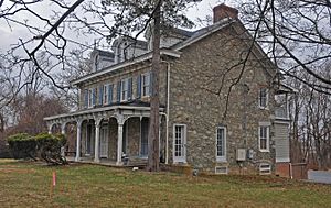
Historic Choate House in Randallstown.
|
|

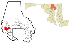
Location of Randallstown, Maryland
|
|
| Country | |
| State | |
| County | |
| Area | |
| • Total | 10.24 sq mi (26.51 km2) |
| • Land | 10.22 sq mi (26.48 km2) |
| • Water | 0.01 sq mi (0.04 km2) |
| Elevation | 584 ft (178 m) |
| Population
(2020)
|
|
| • Total | 33,655 |
| • Density | 3,292.41/sq mi (1,271.20/km2) |
| Time zone | UTC−5 (Eastern (EST)) |
| • Summer (DST) | UTC−4 (EDT) |
| ZIP code |
21133
|
| Area code(s) | 410 |
| FIPS code | 24-64950 |
| GNIS feature ID | 2389725 |
Randallstown is a community in Baltimore County, Maryland, United States. It's called an "unincorporated community" and a "census-designated place." This means it's a recognized area, but it doesn't have its own city government.
The town is named after Christopher and Thomas Randall. They were two brothers who ran a tavern here in the 1700s. Back then, Randallstown was an important stop on the Liberty Turnpike. This was a main road for travelers.
Today, Randallstown is a suburb of Baltimore. A suburb is a smaller town near a big city. In 2020, about 33,655 people lived here. Most of the people in Randallstown are African American. This change happened in the 1990s.
The historic Choate House is in Randallstown. It was added to the National Register of Historic Places in 1989. This means it's an important building with a lot of history.
Contents
Where is Randallstown?
Randallstown is located in Maryland. Its exact location is 39.375272 degrees north and 76.796621 degrees west. The area covers about 10.3 square miles (26.5 square kilometers). All of this area is land.
People in Randallstown
Randallstown has grown over the years. In 1970, about 33,683 people lived here. By 2020, the population was 33,655.
The community is very diverse. In 2020, about 80.68% of the people were Black or African American. About 9.67% were White. Other groups, like Asian, Native American, and people of mixed races, also live here. About 3.60% of the people were Hispanic or Latino.
History of Randallstown
Randallstown started in the 1700s. It was founded by two brothers, Thomas and Christopher Randall. They came from England. They opened a tavern on Liberty Road. This tavern was a place for travelers to stop and rest. By 1880, only about 100 people lived in Randallstown.
Schools in Randallstown
Students in the area go to Randallstown High School.
Getting Around Randallstown
Main Roads
Many important roads run through Randallstown. These include:
- Deer Park Road
- Liberty Road (MD-26)
- Marriottsville Road
- McDonogh Road
- Old Court Road
- Winands Road
Public Transportation
Randallstown was once planned to be the end stop for the Baltimore Metro Subway. But the subway line was built to Owings Mills instead. Even though there are no subway stops in Randallstown, three stops in Baltimore County are very close by.
You can also get around Randallstown by bus. The Maryland Transit Administration has bus routes 54 and 77 that serve the area. There is no bus service between Randallstown and nearby Carroll County.
Famous People from Randallstown
Many talented people have lived in Randallstown. Some of them include:
- Christian Benford, a football player for the Buffalo Bills
- Christian B. Anfinsen, a scientist who won a Nobel Prize
- Victor Abiamiri, a former football player for the Philadelphia Eagles
- Dennis Chambers, a professional drummer
- Domonique Foxworth, a former football player and head of the NFL Players Association
- Michele S. Jones, a former Command Sergeant Major who worked with President Obama
- Mario, a popular R&B and pop singer
- Angel Reese, a basketball player for LSU who was named Most Outstanding Player in 2023
- Sisqo, a singer from the R&B group Dru Hill
See also
 In Spanish: Randallstown (Maryland) para niños

