Randolph, Missouri facts for kids
Quick facts for kids
Randolph, Missouri
|
|
|---|---|
|
City
|
|

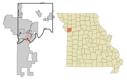
Location of Randolph, Missouri
|
|
| Country | United States |
| State | Missouri |
| County | Clay |
| Area | |
| • Total | 0.34 sq mi (0.88 km2) |
| • Land | 0.32 sq mi (0.84 km2) |
| • Water | 0.02 sq mi (0.05 km2) |
| Elevation | 758 ft (231 m) |
| Population
(2020)
|
|
| • Total | 57 |
| • Density | 176.47/sq mi (68.12/km2) |
| Time zone | UTC-6 (Central (CST)) |
| • Summer (DST) | UTC-5 (CDT) |
| ZIP codes |
64117, 64161
|
| Area code(s) | 816 |
| FIPS code | 29-60590 |
| GNIS feature ID | 2399039 |
Randolph is a small city in Clay County, Missouri, United States. It is completely surrounded by the much larger Kansas City. Randolph is part of the big Kansas City metropolitan area. In 2020, the city had a population of 57 people.
Contents
History of Randolph
Randolph was once known by a different name: "East Kansas City." The city's post office changed its name from East Kansas City to Randolph in 1920. However, the post office later closed its doors in 1928.
Geography of Randolph
Randolph is located right on the banks of the Missouri River. The city covers a total area of about 0.35 square miles (0.88 square kilometers). Most of this area, about 0.33 square miles (0.84 square kilometers), is land. The rest, about 0.02 square miles (0.05 square kilometers), is water. Randolph is completely surrounded by Kansas City on all sides where there is land. Even across the Missouri River, the land belongs to Kansas City.
Randolph's Population Changes
| Historical population | |||
|---|---|---|---|
| Census | Pop. | %± | |
| 1930 | 138 | — | |
| 1940 | 188 | 36.2% | |
| 1950 | 206 | 9.6% | |
| 1960 | 219 | 6.3% | |
| 1970 | 106 | −51.6% | |
| 1980 | 91 | −14.2% | |
| 1990 | 60 | −34.1% | |
| 2000 | 47 | −21.7% | |
| 2010 | 52 | 10.6% | |
| 2020 | 57 | 9.6% | |
| U.S. Decennial Census | |||
The population of Randolph has changed quite a bit over the years. In 1930, there were 138 people living there. The population grew until 1960, when it reached 219 people. After that, the number of residents started to decrease. By 2000, only 47 people lived in Randolph. However, the population has slowly grown again, reaching 57 people in 2020.
Randolph in 2010
According to the census from 2010, there were 52 people living in Randolph. These people lived in 24 different homes, and 14 of these were families. The city had about 157.6 people per square mile. Most of the people living in Randolph (98.1%) were White. A small number (1.9%) were Asian. About 1.9% of the population was Hispanic or Latino.
In the homes, 20.8% had children under 18 years old. About 41.7% of homes were married couples living together. Some homes had a female head (12.5%) or a male head (4.2%) without a spouse. About 33.3% of all homes had only one person living there. The average home had 2.17 people.
The average age of people in Randolph was 47.5 years old. About 17.3% of residents were under 18. Many people (34.5%) were between 45 and 64 years old. About 21.2% were 65 or older. More males lived in Randolph (59.6%) than females (40.4%).
Education in Randolph
Students living in Randolph attend schools in the North Kansas City School District. Younger students go to Topping Elementary School. For middle school, students attend Maple Park Middle School. Older students go to Winnetonka High School.
City Finances and Traffic Tickets
In 2010, the state auditor of Missouri looked at Randolph's finances. The auditor found that a very large part of the city's money, over 73% of its budget, came from fines for traffic violations. This was a concern because it meant the city relied heavily on money from traffic tickets.
See also

- In Spanish: Randolph (Misuri) para niños

