Ravenwood, Missouri facts for kids
Quick facts for kids
Ravenwood, Missouri
|
|
|---|---|

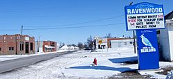
Ravenwood in 2009
|
|
| Motto(s):
Village in the Valley
|
|

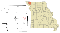
Location of Ravenwood, Missouri
|
|
| Country | United States |
| State | Missouri |
| County | Nodaway |
| Township | Jackson |
| Area | |
| • Total | 0.30 sq mi (0.78 km2) |
| • Land | 0.30 sq mi (0.78 km2) |
| • Water | 0.00 sq mi (0.00 km2) |
| Elevation | 1,034 ft (315 m) |
| Population
(2020)
|
|
| • Total | 439 |
| • Density | 1,453.64/sq mi (562.13/km2) |
| Time zone | UTC-6 (Central (CST)) |
| • Summer (DST) | UTC-5 (CDT) |
| ZIP code |
64479
|
| Area code(s) | 660 |
| FIPS code | 29-60716 |
| GNIS feature ID | 2396869 |
Ravenwood is a small city located in eastern Nodaway County, Missouri, in the United States. It's close to the Platte River. In 2020, about 439 people lived there.
Contents
Discovering Ravenwood's Past
Ravenwood was officially started in 1887. This happened when a railroad line was built to reach that area. The community got its name from the person who originally owned the land where the city now stands. A post office, which helps send mail, has been open in Ravenwood since 1888.
Exploring Ravenwood's Location
Ravenwood is found along Missouri Route 46. It's just north of where Route 46 meets US Route 136. The city of Maryville is about ten miles west if you follow Route 136. Parnell is six miles northeast on Route 46. The Platte River flows right past the western side of the city.
According to the United States Census Bureau, Ravenwood covers a total area of about 0.27 square miles (0.70 km2). All of this area is land, meaning there are no large lakes or rivers within the city limits.
Understanding Ravenwood's Population
| Historical population | |||
|---|---|---|---|
| Census | Pop. | %± | |
| 1900 | 285 | — | |
| 1910 | 341 | 19.6% | |
| 1920 | 344 | 0.9% | |
| 1930 | 336 | −2.3% | |
| 1940 | 336 | 0.0% | |
| 1950 | 319 | −5.1% | |
| 1960 | 282 | −11.6% | |
| 1970 | 336 | 19.1% | |
| 1980 | 436 | 29.8% | |
| 1990 | 409 | −6.2% | |
| 2000 | 448 | 9.5% | |
| 2010 | 440 | −1.8% | |
| 2020 | 439 | −0.2% | |
| U.S. Decennial Census | |||
Ravenwood's 2010 Population Count
In 2010, a special count called a census showed that 440 people lived in Ravenwood. These people lived in 185 different homes, and 119 of these were families. The city had a population density of about 1,629.6 inhabitants per square mile (629.2/km2). This means there were about 1,630 people for every square mile of land.
Most people living in Ravenwood in 2010 were White. A very small number were African American or from two or more races. Also, a tiny part of the population was of Hispanic or Latino background.
Out of all the homes, about 30% had children under 18 living there. More than half of the homes were married couples living together. About 14% of homes had someone living alone who was 65 years old or older. The average number of people in each home was about 2.38.
The average age of people in Ravenwood in 2010 was 36.7 years old. About 26% of residents were under 18. About 14.5% were 65 years old or older. The city had slightly more females (52.5%) than males (47.5%).
See also
 In Spanish: Ravenwood (Misuri) para niños
 | Claudette Colvin |
 | Myrlie Evers-Williams |
 | Alberta Odell Jones |

