
Ray City, Georgia facts for kids
Quick facts for kids
Ray City, Georgia
|
||
|---|---|---|

Ray City Municipal Building
|
||
|
||

Location in Berrien County and the state of Georgia
|
||
| Country | United States | |
| State | Georgia | |
| Counties | Berrien, Lanier | |
| Area | ||
| • Total | 1.15 sq mi (2.97 km2) | |
| • Land | 1.15 sq mi (2.97 km2) | |
| • Water | 0.00 sq mi (0.00 km2) | |
| Elevation | 190 ft (58 m) | |
| Population
(2020)
|
||
| • Total | 956 | |
| • Density | 834.21/sq mi (322.03/km2) | |
| Time zone | UTC-5 (Eastern (EST)) | |
| • Summer (DST) | UTC-4 (EDT) | |
| ZIP code |
31645
|
|
| Area code(s) | 229 | |
| FIPS code | 13-63728 | |
| GNIS feature ID | 0332800 | |

Ray City is a small city located in the state of Georgia, United States. It is found in two different counties: Berrien County and Lanier County. In 2020, about 956 people lived there.
Contents
History of Ray City
Ray City has had a few different names over time. It was once called "Ray's Pond" and "Ray's Mill." The community got its name from a man named Thomas M. Ray. He owned a mill in the area, which was a place where grain was ground into flour.
Geography and Location
Ray City is mostly in the southern part of Berrien County. A small piece of the city also reaches into Lanier County.
Getting Around Ray City
U.S. Route 129 is a main road that goes through Ray City.
- If you go north on this road for about 10 miles, you will reach Nashville. Nashville is the main town, or county seat, for Berrien County.
- If you go east for about 8 miles, you will get to Lakeland. This is the county seat for Lanier County.
- Georgia State Route 125 goes south from Ray City. It's about 18 miles to Valdosta.
- State Route 37 heads west for about 14 miles to Adel.
Land and Water
Ray City covers a total area of about 3.0 square kilometers (1.15 square miles). Most of this area is land. Only a very small part, about 0.07%, is water.
Two streams flow through the city:
- Beaverdam Creek runs through the middle of Ray City.
- Batterbee Branch flows through the western side.
These two streams meet west of Ray City to form Cat Creek. Cat Creek then flows south and joins the Withlacoochee River. The Withlacoochee River is part of the larger Suwannee River system.
People of Ray City (Demographics)
Demographics is the study of the people who live in a certain area. It looks at things like how many people there are, their ages, and their backgrounds.
| Historical population | |||
|---|---|---|---|
| Census | Pop. | %± | |
| 1910 | 300 | — | |
| 1920 | 700 | 133.3% | |
| 1930 | 602 | −14.0% | |
| 1940 | 638 | 6.0% | |
| 1950 | 576 | −9.7% | |
| 1960 | 713 | 23.8% | |
| 1970 | 617 | −13.5% | |
| 1980 | 658 | 6.6% | |
| 1990 | 603 | −8.4% | |
| 2000 | 746 | 23.7% | |
| 2010 | 1,090 | 46.1% | |
| 2020 | 956 | −12.3% | |
| U.S. Decennial Census 1850-1870 1870-1880 1890-1910 1920-1930 1940 1950 1960 1970 1980 1990 2000 2010 |
|||
Population in 2020
According to the 2020 United States census, there were 956 people living in Ray City. These people lived in 484 different households, and 313 of these households were families.
Here's a look at the different groups of people living in Ray City in 2020:
| Race | Number of People | Percentage |
|---|---|---|
| White (not Hispanic or Latino) | 621 | 64.94% |
| Black or African American (not Hispanic or Latino) | 205 | 21.44% |
| Native American | 1 | 0.1% |
| Asian | 9 | 0.94% |
| Other/Mixed (two or more races) | 39 | 4.08% |
| Hispanic or Latino | 81 | 8.47% |
Education
Students living in Ray City attend different school districts depending on which county they live in:
- If they live in Berrien County, they go to schools in the Berrien County School District.
- If they live in Lanier County, they go to schools in the Lanier County School District.
Gallery
-
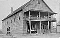
Ray City Hotel, around 1912
-

Historic Ray City High School building
-
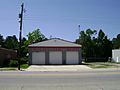
Ray City Fire Department
-
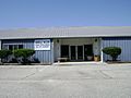
Juanelle Wilson Senior Citizen Center
.jpg)


See also
 In Spanish: Ray City para niños
