Raydon facts for kids
Quick facts for kids Raydon |
|
|---|---|
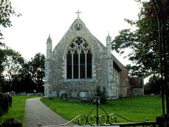
 St. Mary's church, Raydon |
|
| Population | 507 (2001 and 2011) |
| OS grid reference | TM0438 |
| District |
|
| Shire county | |
| Region | |
| Country | England |
| Sovereign state | United Kingdom |
| Post town | IPSWICH |
| Postcode district | IP7 |
| Dialling code | 01473 |
| EU Parliament | East of England |
Raydon is a small village in Suffolk, England. It is located about two miles south-east of Hadleigh. Raydon is part of the Babergh area.
The village also includes two smaller areas called hamlets: Lower Raydon to the west and The Woodlands to the east. Raydon has a long history. It was first written about in the Domesday Book as "Reindune" or "Reinduna." Later, in 1610, it appeared on an old map by John Speed as "Roydon."
Contents
Exploring Raydon Village
Raydon is built along a road called The Street, which is part of the B1070. This road runs from north to south through the village. St. Mary's church, an important local building, is located near where The Street meets Woodlands Road in the northern part of the village.
Raydon Mill: A Historic Building
Raydon Mill is an old building located about a mile west of the village, above Lower Raydon. It was built sometime after the Middle Ages. During World War II, the mill was used to hold German prisoners of war. Today, it is a home, but you can still see parts of its past, like the old turbine and grinding stones.
Nature and Green Spaces
Raydon is surrounded by beautiful natural areas. The southern and western parts of the village, including Lower Raydon, are part of the Dedham Vale Area of Outstanding Natural Beauty (AONB). An AONB is a special place recognized for its amazing natural beauty.
Ancient Woodlands and Nature Reserves
The northern part of Raydon parish has several nature reserves. These include Raydon Great Wood, Long Wood, Squares Grove, and Tom's Wood. All of these are ancient woodlands, meaning they have been continuously forested for hundreds of years.
An old railway line, called the Hadleigh Railway, used to run through Raydon Great Wood. There was even a station called Raydon Wood. This old railway line is now also a nature reserve, providing a home for many plants and animals.
Golfing in Raydon
If you enjoy golf, the Brett Vale Golf Club is located to the west of the village. It offers a place for people to play and enjoy the outdoors.
Raydon's Wartime History
Raydon Hall Farm is about one kilometer northeast of the village. The War Memorial, which remembers those who served in wars, is another kilometer further along Woodlands Road.
RAF Raydon Airfield
During World War II, a large airfield was built in this area. It was first known as USAAF Station 157, used by the United States Army Air Forces. Later, it became RAF Raydon when the British Royal Air Force took it over. Construction of the airfield began in the summer of 1942. American engineers helped build it. The people working at the airfield lived near a place called Great Wenham. Today, the buildings that are left from the old airfield are part of Notley Enterprise Park.
Raydon Hall (TM0529039055) is also in this area. It is a Grade II listed building, which means it is an important historic building that is protected.
Past Village Life
Raydon used to have two pubs, the Chequers (which was once called Horseshoes) and the Fox. However, both of these pubs have been closed for many years.
 | Ernest Everett Just |
 | Mary Jackson |
 | Emmett Chappelle |
 | Marie Maynard Daly |


