Readmond Township, Michigan facts for kids
Quick facts for kids
Readmond Township, Michigan
|
|
|---|---|

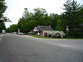
Unincorporated community of Good Hart
|
|

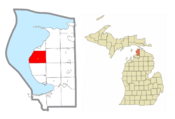
Location within Emmet County
|
|
| Country | United States |
| State | Michigan |
| County | Emmet |
| Established | 1877 |
| Area | |
| • Total | 31.03 sq mi (80.4 km2) |
| • Land | 31.03 sq mi (80.4 km2) |
| • Water | 0.0 sq mi (0 km2) |
| Elevation | 869 ft (265 m) |
| Population
(2020)
|
|
| • Total | 560 |
| • Density | 18.05/sq mi (6.97/km2) |
| Time zone | UTC-5 (Eastern (EST)) |
| • Summer (DST) | UTC-4 (EDT) |
| ZIP Code(s) | |
| Area code(s) | 231 |
| FIPS code | 26-67540 |
| GNIS feature ID | 1626958 |
Readmond Township is a small area in Emmet County, Michigan, in the United States. It's a type of local government area called a civil township. In 2020, about 560 people lived here.
Contents
Exploring Readmond Township's Communities
Readmond Township is home to a special place called Good Hart. It's an unincorporated community, which means it's a group of homes and businesses that aren't officially a city or town. Good Hart is right on the shore of Lake Michigan.
Good Hart's Location and History
Good Hart is located about 13 miles (21 km) north of Harbor Springs. It's also about 8 miles (13 km) south of Cross Village. This area was very important to the Ojibwe people in the early 1800s. Leaders like Joseph Black Hawk and his brother Good Heart lived here.
The Rich History of Readmond Township
The area where Readmond Township is located has a long and interesting history. Native Americans knew this place as L'Arbre Croche, which means "crooked tree."
Early Settlements and Missions
In 1741, a group of Jesuits (a type of Christian missionary) started a mission here for the Native Americans. This mission was known as Apatawaaing. By 1823, the Jesuits had built the first building in the area, and it became known as Middle Village. A church called St. Ignatius Church was built, but it was destroyed by fire in 1889. Luckily, it was rebuilt afterward.
Geography of Readmond Township
Readmond Township covers a total area of about 31.03 square miles (80.37 square kilometers). All of this area is land, meaning there are no large lakes or rivers within the township's official boundaries.
Who Lives in Readmond Township?
In 2000, there were 493 people living in Readmond Township. These people made up 198 households, with many of them being families.
Population Details
The population density was about 15.9 people per square mile. This means there weren't too many people living close together. The average household had about 2.49 people, and the average family had about 2.85 people.
The people living in the township were of different ages:
- About 23.5% were under 18 years old.
- About 5.5% were between 18 and 24 years old.
- About 26.4% were between 25 and 44 years old.
- About 30.6% were between 45 and 64 years old.
- About 14.0% were 65 years or older.
The average age of people in the township was 42 years.
See also
 In Spanish: Municipio de Readmond para niños
 | Frances Mary Albrier |
 | Whitney Young |
 | Muhammad Ali |


