
Red Butte Creek (Salt Lake County, Utah) facts for kids
Quick facts for kids Red Butte Creek |
|
|---|---|

Red Butte Creek feeds several water features in Red Butte Garden
|
|
_Watershed.jpg)
Little Cottonwood Creek and other Salt Lake County streams
|
|
| Country | United States |
| State | Utah |
| Physical characteristics | |
| Main source | Red Butte Canyon, Utah, Salt Lake County, Utah 8,000 ft (2,400 m) 40°48′51″N 111°44′51″W / 40.81417°N 111.74750°W |
| River mouth | Jordan River Salt Lake City, Utah, Salt Lake County, Utah 4,400 ft (1,300 m) 40°44′42″N 111°51′26″W / 40.74500°N 111.85722°W |
| Length | 15.3 mi (24.6 km) |
| Basin features | |
| Basin size | 7.25 sq mi (18.8 km2) |
Red Butte Creek is a small stream in Utah. It starts high up in the mountains of Salt Lake County. The creek flows west through beautiful places like the Red Butte Garden and Arboretum and past the University of Utah. It then goes southwest until it reaches Liberty Park in Salt Lake City.
Red Butte Canyon, where the creek begins, is the smallest of seven canyons in eastern Salt Lake County. It's a special place with elevations from 5,000 to 8,000 feet above sea level. The creek's watershed, or the area of land that drains into it, is about 7.25 square miles.
Contents
A Look Back at Red Butte Creek
In the early 1850s, people thought about using stone from Red Butte Canyon to build the Salt Lake Temple for LDS. They even considered building a wooden railroad to move the stone! But in 1855, they decided to use granite from Little Cottonwood Canyon instead.
There's a monument near the creek in Salt Lake City that tells a cool story. It remembers how early pioneers drowned sacks of Mormon crickets in the creek. This happened during a time when there were many crickets causing problems.
Protecting the Water
The United States Army started using water from Red Butte Creek in 1862. This was when Fort Douglas was built at the mouth of the canyon. Even though they used the water, the Army worked hard to protect the creek's watershed and keep the water clean.
Over the years, this protection grew stronger. In 1969, the U.S. Forest Service took over the canyon. They declared it a Research Natural Area, which means it's a special place kept safe for study.
Early pioneers also used Red Butte Creek for irrigation to water their crops. By 1875, the Army built two reservoirs east of Fort Douglas. They diverted water from the creek to fill these reservoirs.
To stop pollution from quarrying (stone digging), a court ruled in 1890 that the creek's water belonged only to the U.S. Army. That same year, a U.S. Congress law protected Fort Douglas's water supply. This law stopped any land sales or building in the canyon.
The Army built a dam on the creek in 1906 for more water. The current dam was built between 1928 and 1930. This reservoir supplied water to Fort Douglas until it closed in 1991.
Red Butte Creek is a stream that flows all year round. It has created a narrow canyon with steep sides.


How Red Butte Creek Flows
The amount of water flowing in Red Butte Creek changes throughout the year. This is called discharge. From 1964 to 1988, the average flow into the reservoir was about 0.133 cubic meters per second.
The creek's flow follows a clear yearly pattern. In spring, a lot of water flows from melting snow. This "snowmelt" flow is much higher than at other times. It usually peaks in May and lasts for six to eight weeks. The average flow in May is about 0.416 cubic meters per second.
By September, the flow is much lower, around 0.058 cubic meters per second. Even though summer gets a lot of rain, the stream flow doesn't usually increase then. The daily flow can change a lot during snowmelt, depending on air temperatures and how much snow is in the canyon.
Record High Flow
The winter of 1982–83 had a lot of snow along the Wasatch Front. In May 1983, heavy snows were followed by unusually warm temperatures. This caused the creek's flow to reach record levels.
On May 28, 1983, Red Butte Creek had its highest recorded flow. The water moved at more than 2.97 cubic meters per second! This was the biggest flow in recent times, much higher than the previous record from May 18, 1975.
Ecosystem and Wildlife
The U.S. Forest Service manages Red Butte Canyon as a protected area. It's gated to keep the public out. This makes it the most untouched natural area along the Wasatch Front.
The Utah Field Office of the U.S. Fish and Wildlife Service reported something exciting in 1994. They said that 400 endangered June sucker fish were placed in the reservoir, and they were doing very well!
Chevron Pipeline Incident
On June 12, 2010, an oil spill happened near Red Butte Creek. A pipeline owned by Chevron Corporation had a problem. Oil spilled into the creek, outside the Red Butte Garden. The spill was stopped later that day, but some oil reached the Jordan River. Animals affected by the oil were taken to Hogle Zoo for help and treatment.
Images for kids
-
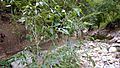
Young Narrowleaf Cottonwood Tree used to restore Red Butte Creek's banks in Salt Lake City, October 2015
-
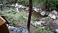
Red Butte Creek after restoration on October 5, 2015
