
Redange facts for kids
Quick facts for kids
Redange
Réiden
|
||
|---|---|---|

Saint-Victor church, Redange.
|
||
|
||

Map showing, in orange, the Redange commune
|
||
| Country | ||
| Canton | Redange | |
| Commune | Redange | |
| Area | ||
| • Total | 31.9 km2 (12.3 sq mi) | |
| Highest elevation | 493 m (1,617 ft) | |
| Lowest elevation | 253 m (830 ft) | |
| Population
(2017)
|
||
| • Total | 2,795 | |
| • Density | 87.62/km2 (226.9/sq mi) | |
| Time zone | UTC+1 (CET) | |
| • Summer (DST) | UTC+2 (CEST) | |
| LAU2 | LU00003006 | |
| Website | Official website: http://www.redange.lu/ | |

Redange, also known as Redange-sur-Attert (or Réiden in Luxembourgish), is a charming town and a commune (which is like a local district) in western Luxembourg. It's located very close to the border with Belgium. This town is also the main center, or capital, of the Redange canton, which is a larger administrative area.
Contents
Exploring Redange's Location
Redange is nestled in a valley right by the Attert River, which is a smaller river that flows into the Alzette river. This area is special because it sits on the edge of two natural regions of Luxembourg: the Oesling to the north and the Gutland.
The entire commune of Redange covers an area of about 31.9 square kilometers (that's about 12.3 square miles!). The land here varies in height, from 253 meters (830 feet) to 493 meters (1,617 feet) above sea level. The church in Redange is located at an altitude of 286 meters (938 feet).
Neighboring Communes
Redange is surrounded by five other communes in Luxembourg, all of which are part of the Redange canton. These neighbors are Rambrouch, Préizerdaul, Useldange, Beckerich, and Ell.
 |
Rambrouch | Préizerdaul | |
|
| Ell | Useldange | |||
| Beckerich |
People Living in Redange
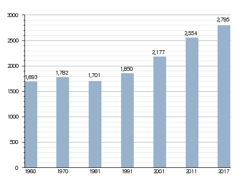
In 2017, there were 2,795 people living in the Redange commune. This means the population density was about 87.6 people per square kilometer.
Besides the main town of Redange, the commune also includes several other smaller towns. These are Lannen, Nagem, Niederpallen, Ospern, and Reichlange.
How Redange's Population Has Grown
The number of people living in Redange has changed over the years. You can see how the population has grown in the chart below.
Evolution of the population in Redange
Images for kids
-
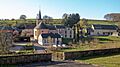
Church in Nagem, Redange.
-
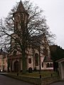
Saint-Victor church, Redange.


Related Pages
- Cantons of Luxembourg
- Communes of Luxembourg
- List of cities in Luxembourg
